Earthquake Hazards Program
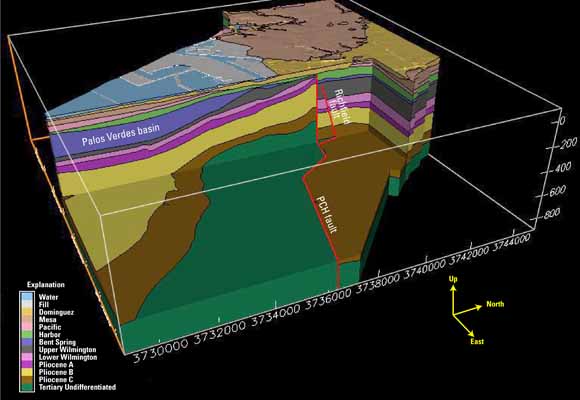
Chair slice through the 3D model, showing structure and stratigraphy beneath the Los Angeles river channel extending from San Pedro Bay north into Long Beach (from figure 3)
A 3-dimensional computer model of the Quaternary sequence stratigraphy in the Dominguez gap region of Long Beach, California has been developed to provide a robust chronostratigraphic framework for hydrologic and tectonic studies. The model consists of 13 layers within a 16.5 by 16.1 km (10.25 by 10 mile) square area and extends downward to an altitude of –900 meters (–2952.76 feet). Ten sequences of late Pliocene to Holocene age are identified and correlated within the model. Primary data to build the model comes from five reference core holes, extensive high-resolution seismic data obtained in San Pedro Bay, and logs from several hundred water and oil wells drilled in the region. The model is best constrained in the vicinity of the Dominguez gap seawater intrusion barrier where a dense network of subsurface data exist. The resultant stratigraphic framework and geologic structure differs significantly from what has been proposed in earlier studies.
An important new discovery from this approach is the recognition of ongoing tectonic deformation throughout nearly all of Quaternary time that has impacted the geometry and character of the sequences. Anticlinal folding along a NW-SE trend, probably associated with Quaternary reactivation of the Wilmington anticline, has uplifted and thinned deposits along the fold crest, which intersects the Dominguez gap seawater barrier near Pacific Coast Highway. A W-NW trending fault system that approximately parallels the fold crest has also been identified. This fault progressively displaces all but the youngest sequences down to the north and serves as the southern termination of the classic Silverado aquifer.
Uplift and erosion of fining-upward paralic sequences along the crest of the young fold has removed or thinned many of the fine-grained beds that serve to protect the underlying Silverado aquifer from seawater contaminated shallow groundwater. As a result of this process, the potential exists for vertical migration of seawater into the producing aquifers and subsequent landward migration of intruded waters beneath the existing Dominguez barrier. Incipient invasion of the Silverado aquifer by chloride-enriched waters is observed in a recently drilled well located along the crest of the fold seaward of the barrier and at a depth of 440 feet (134 meters).
These new observations and interpretations indicate that the new sequence-based approach to defining the stratigraphy of the Dominguez Gap area may have important implications for seawater intrusion management. To test this, it will be useful to overlay existing water-quality and water level data onto the framework model and to incorporate the new stratigraphy into a transport model.
Download this report as a 38-page PDF file (of2007-1013.pdf; 2.7 MB)
Go to the figures folder to get the original artwork that went into this report (16 items that total 36.2 MB)
For questions about the content of this report, contact Dan Ponti
Download a copy of the latest version of Adobe Reader for free.
|
Help |
PDF help |
Publications main page |
| Western Open-File Reports for 2007 |
| Geologic Division |
Earthquake Hazards Program
|

![]() U.S. Department of the Interior | U.S. Geological Survey
U.S. Department of the Interior | U.S. Geological Survey
URL: https://pubs.usgs.gov/of/2007/1013/
Page Contact Information: Michael Diggles
Page Last Modified: January 9, 2008