Earthquake Hazards Program
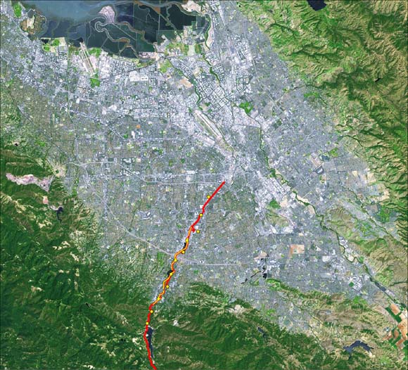
The Santa Clara Valley (SCV) is located in the southern San Francisco Bay area of California and is bounded by the Santa Cruz Mountains to the southwest, the Diablo Ranges to the northeast, and the San Francisco Bay to the north (Fig. 1). The SCV, which includes the City of San Jose, numerous smaller cities, and much of the high-technology manufacturing and research area commonly referred to as the Silicon Valley, has a population in excess of 1.7 million people (2000 U. S. Census;http://quickfacts.census.gov/qfd/states/06/06085.html The SCV is situated between major active faults of the San Andreas Fault system, including the San Andreas Fault to the southwest and the Hayward and Calaveras faults to the northeast, and other faults inferred to lie beneath the alluvium of the SCV (CWDR, 1967; Bortugno et al., 1991). The importance of the SCV as a major industrial center, its large population, and its proximity to major earthquake faults are important considerations with respect to earthquake hazards and water-resource management. The fault-bounded alluvial aquifer system beneath the valley is the source of about one-third of the water supply for the metropolitan area (Hanson et al., 2004).
To better address the earthquake hazards of the SCV, the U.S. Geological Survey (USGS) has undertaken a program to evaluate potential seismic sources, the effects of strong ground shaking, and stratigraphy associated with the regional aquifer system. As part of that program and to better understand water resources of the valley, the USGS and the Santa Clara Valley Water District (SCVWD) began joint studies to characterize the faults, stratigraphy, and structures beneath the SCV in the year 2000. Such features are important to both agencies because they directly influence the availability and management of groundwater resources in the valley, and they affect the severity and distribution of strong shaking from local and regional earthquakes sources that may affect reservoirs, pipelines, and flood-protection facilities maintained by SCVWD. As one component of these joint studies, the USGS acquired an approximately 10-km-long, high-resolution, combined seismic reflection/refraction transect from the Santa Cruz Mountains to the central SCV in December 2000 (Figs. 1 and 2a,b). The overall seismic investigation of the western Santa Clara Valley also included an ~18-km-long, lower-resolution (~50-m sensor) seismic imaging survey from the central Santa Cruz Mountains to the central part of the valley (Fig. 1). Collectively, we refer to these seismic investigations as the 2000 western Santa Clara Seismic Investigations (SCSI). Results of the high-resolution investigation, referred to as SCSI-HR, are presented in this report, and Catchings et al. (2006) present results of the low-resolution investigation (SCSI-LR) in a separate report. In this report, we present data acquisition parameters, unprocessed and processed seismic data, and interpretations of the SCSI-HR seismic transect.
Download this report as a 70-page PDF file (of2007-1039.pdf; 54.9 MB with links to another 102 MB of oversized figures).
Oversized figures are also available below as individual files.
Figure 20, ~40" x 7" (of2007-1039_fig20.pdf; 15.5 MB).
Figure 21, ~35" x 12" (of2007-1039_fig21.pdf; 17.1 MB).
Figure 22, ~38" x 8" (of2007-1039_fig22.pdf; 37.4 MB).
Figure 23, ~23" x 8" (of2007-1039_fig23.pdf; 6.7 MB).
Figure 24, ~23" x 10" (of2007-1039_fig24.pdf; 10.8 MB).
Figure 26, ~27" x 11" (of2007-1039_fig26.pdf; 14.6 MB).
For questions about this report, contact Rufus Catchings.
Suggested citation and version history
Download a current version of Adobe Reader for free
| Help | PDF help | Publications main page | Western Open-File Reports for 2007 |
| Geology | Earthquake Hazards Program |
This report is available only on the Web

![]() U.S. Department of the Interior | U.S. Geological Survey
U.S. Department of the Interior | U.S. Geological Survey
URL: https://pubs.usgs.gov/of/2007/1039/
Page Contact Information: Michael Diggles
Page Last Modified: January 9, 2008
(mfd)