Western Mineral Resources
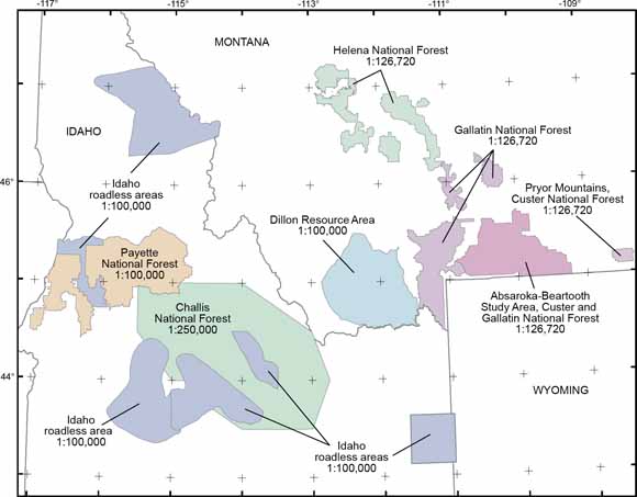
Sketch map of the study area, showing the locations of USFS National Forest and BLM Resource Area assessments conducted by the USGS in Idaho and Montana (from figure 2).
Legislation to establish the U.S. Geological Survey for "classification of the public lands, and examination of the geological structure, mineral resources, and products of the national domain" was included in the bill appropriating funds for the Federal Government for the fiscal year beginning July 1, 1879. Since that time, the USGS has studied and provided impartial information on the occurrence, quality, quantity, and availability of mineral resources (Kropschot, 2006). Mineral resource assessments are one way in which this information is communicated.
This report compiles the results of two USGS programs that assessed undiscovered mineral resource potential in Idaho and Montana. The first program assessed the mineral potential of 1° x 2° quadrangles whereas the second focused specifically on National Forests. Because USGS assessment methodology evolves, in order to meet the changing needs of the end-users and to address the quality and quantity of available information, the assessment methods for the two programs are different. However, both approaches delineate areas with potential for undiscovered mineral resources associated with a particular deposit type and estimate the degree of potential for the area.
This report compiles areas of mineral potential and their degree of potential from published mineral resource maps into consistent spatial databases. The 13 USGS mineral resource assessment areas included in this compilation are (1) the Absaroka-Beartooth study area, Custer and Gallatin National Forests (Hammarstrom and others, 1993); (2) the Dillon BLM Resource Area (Hammarstrom and others, 1999; Van Gosen and others, 1998a; Van Gosen and others, 1998b); (3) the Gallatin National Forest (Wilson and others, 2005); (4) the Helena National Forest (Tysdal and others, 1996; Green and Tysdal,
1996); (5) the National Forest roadless areas in Idaho (Johnson and Worl, 1991); (6) the Payette National Forest (Bookstrom and others, 1998); (7) the Custer National Forest in the Pryor Mountains (Van Gosen and others, 1996); (8) the Butte 1° x 2° quadrangle (Elliott and others, 1992a; Elliott and others, 1992b; Elliott and others, 1993b); (9) the Challis 1° x 2° quadrangle (Fisher and Johnson, 1995); (10) the Challis National Forest (Worl and others, 1989); (11) the Choteau 1° x 2° quadrangle (Earhart and others, 1981b); (12) the Dillon 1° x 2° quadrangle (Pearson and others, 1990; Pearson and others, 1991; Pearson and others, 1992a; Pearson and others, 1992b); and (13) the Wallace 1° x 2° quadrangle (Harrison, Cressman, and others, 1986; Harrison, Domenico, and Leach, 1986a; Harrison, Domenico, and Leach, 1986b; Harrison and others, 1986a; Harrison and others, 1986b).
The mineral resource maps developed for these assessments were published in a variety of formats: most commonly as printed material, but also as spatial database files using the ESRI coverage and shapefile format, as well as the USGS GSMAP format (Selner and Taylor, 1993). This report describes the mineral resource assessments, the methods used to convert the mineral resource map data into a digital format, and the spatial database file structures and relationships. This report does not provide all digital data needed to reproduce the printed image of the resource assessment map; base material, geologic features selected from geologic maps used to provide context, or point data derived from USGS mineral occurrence databases are not included in this compilation. Spatial data commonly used as base material in printed maps may be obtained from a variety of commercial and government sources. Larsen and others (2004) and Zientek and others (2005) published digital geologic maps that cover these study areas. Mineral occurrence data from the USGS Mineral Resources Data System (MRDS) can be obtained online from http://tin.er.usgs.gov/mrds/ [Accessed November 8, 2006].
This digital compilation is part of an ongoing effort to provide mineral resource information as databases for use in spatial analysis. In particular, this is one of several reports prepared to address USFS needs for science information as forest management plans are revised in the Northern Rocky Mountains (Zientek and Kropschot, 2005). The results of mineral resource assessments will be used in conjunction with mineral deposit (Spanski, 2001; Klein, 2004, Spanski, 2004) and mining claim information (Causey, 2005) to indicate where minerals-related activities might take place in the near future.
Download the text for this report as a 33-page PDF file (of2007-1101.pdf; 952 kB).
Readme file as an ASCII file: this is a file that describes the product and its digital components (readme.txt; 16 kB).
3-part_master_metadata.htm (72 kB)
3-part_lineonly_master_metadata.htm (40 kB)
non_3-part_master_metadata.htm (72 kB)
Spatial databases in ArcGIS export (interchange) format as a .zip file (Export.zip; 23.7 MB; opens to a 102.4 MB folder). These files MUST be processed before using in a GIS.
Spatial databases in ArcGIS coverage format as a .zip file (Spatial.zip; 23.1 MB; opens to a 95.9 MB folder). These files may be used in ArcGIS without further processing.
For questions about the content of this report, contact Mary Carlson (CACI) or Mike Zientek (USGS).
Suggested citation and version history
Download a current version of Adobe Reader for free
| Help
| PDF help
| Publications main page | Western Open-File Reports for 2007 |
| Geologic
Division | Western Mineral Resources
|
This report is also available only on the Web

![]() U.S. Department of the Interior | U.S. Geological Survey
U.S. Department of the Interior | U.S. Geological Survey
URL: https://pubs.usgs.gov/of/2007/1101/
Page Contact Information: Michael Diggles
Page Last Modified: January 9, 2008
