Open-File Report 2007–1208
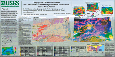 
Abstract The Cenozoic basins of interior Alaska are poorly understood, but may host undiscovered hydrocarbon resources in sufficient quantities to serve remote villages and for possible export. Purported oil seeps and the regional occurrence of potential hydrocarbon source and reservoir rocks fuel an exploration interest in the 46,000 km2 Yukon Flats basin. Whether hydrocarbon source rocks are present in the pre-Cenozoic basement beneath Yukon Flats is difficult to determine because vegetation and surficial deposits obscure the bedrock geology, only limited seismic data are available, and no deep boreholes have been drilled. Analysis of regional potential field data (aeromagnetics and gravity) is valuable, therefore, for preliminary characterization of basement lithology and structure. We present our analysis as a red-green-blue composite spectral map consisting of: (1) reduced-to-the-pole magnetics (red), (2) magnetic potential (green), and (3) basement gravity (blue). The color and texture patterns on this composite map highlight domains with common geophysical characteristics and, by inference, lithology. The observed patterns yield the primary conclusion that much of the basin is underlain by Devonian to Jurassic oceanic rocks related to the Angayucham and Tozitna terranes (JDat). These rocks are part of a lithologically diverse assemblage of brittlely deformed, generally low-grade metamorphic rocks of oceanic affinity; such rocks probably have little or no potential for hydrocarbon generation. The JDat geophysical signature extends from the Tintina fault system northward to the Brooks Range. Along the eastern edge of the basin, JDat appears to overlie moderately dense and non-magnetic Proterozoic(?) and Paleozoic continental margin rocks. The western edge of the JDat in subsurface is difficult to distinguish due to the presence of magnetic granites similar to those exposed in the Ruby geanticline. In the southern portion of the basin, geophysical patterns indicate the possibility of overthrusting of Cenozoic sediments and underlying JDat by Paleozoic and Proterozoic rocks of the Schwatka sequence. These structural hypotheses provide the basis for an overthrust play within the Cenozoic section just south of the basin. |
Version 1.0 Posted July 2007
This text-only version of the Plate is accessible as defined by Section 508.
|
Saltus, R.W., Phillips, J.D., Stanley, R.G., Till, A., Morin, R.L., 2007, Geophysical characterization of pre-Cenozoic basement for hydrocarbon assessment, Yukon Flats, Alaska: U.S. Geological Survey Open-File Report 2007-1208, 1 plate.

![]() U.S. Department of the Interior | U.S. Geological Survey
U.S. Department of the Interior | U.S. Geological Survey
URL: http://pubsdata.usgs.gov/pubs/of/2007/1208/index.html
Questions or Assistance: Contact USGS
Last modified: Wednesday, 07-Dec-2016 20:18:24 EST
