Coastal and Marine Geology Program
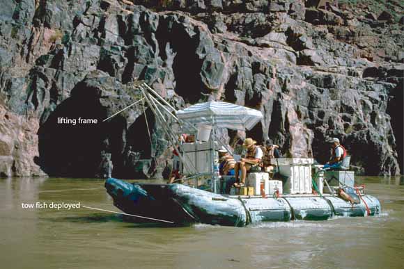
A 22-ft snout rig inflatable boat was used to collect side-scan data. White plastic waterproof boxes housed all electronics. The side-scan tow fish was raised and lowered using the lifting fame at the bow of the vessel (from figure 2)
This paper presents data collection methods and side-scan sonar data collected along the Colorado River in Grand Canyon in August and September of 2000. The purpose of the data collection effort was to image the distribution of sand between Glen Canyon Dam and river mile 87.4 before and after the 31,600 cfs flow of September 6-8. The side-scan sonar imaging focused on pools between rapids but included smaller rapids where possible.
Download this report as a 15-page PDF file (of2007-1216.pdf; 1.9 MB).
View the R3-R4 uninterpreted images (R3-R4_uninterpreted folder; 29 PDF files, 596 MB).
R3-R4_uninterpretedFor questions about the content of this report, contact Roberto Anima
Suggested citation and version history
Download a free copy of the latest version of Adobe Reader.
|
Help |
PDF help |
Publications main page |
| Western Open-File Reports for 2007 |
| Geology | Coastal and Marine Geology
|

![]() U.S. Department of the Interior | U.S. Geological Survey
U.S. Department of the Interior | U.S. Geological Survey
URL: https://pubs.usgs.gov/of/2007/1216/
Page Contact Information: Michael Diggles
Page Last Modified: January 11, 2008