Southwest Biological Science Center
In cooperation with the National Park Service
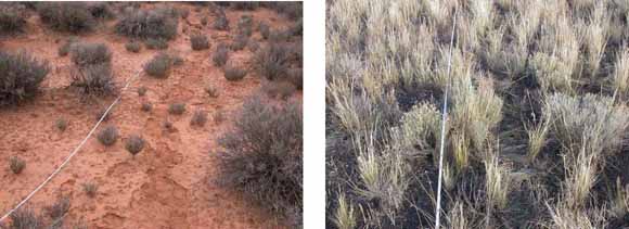
Photograph (left) of destabilized soil and trampled biological soil crusts on unsampled side of transect in Arches National Park (Semidesert Shallow Sandy Loam ecological site), and (right) trampled plants on unsampled side of transect in Wupatki National Monument (Limy Upland ecological site) (from figure 20).
To inform planning for long-term ecological monitoring, we sampled vegetation and soil-surface attributes across a range of terrestrial ecosystems (physiognomic types) in seven National Park Service units on the Colorado Plateau. Primary objectives were (1) to evaluate a suite of sampling methods according to measures of repeatability, efficiency, and impacts on plot conditions; and (2) to characterize within- and among-plot variability in monitoring measures. This work was designed to support NPS staff in selecting the combination of methods that best meets their monitoring objectives and resource constraints. We found no differences among cover-estimation techniques in terms of repeatability between observers (measurement precision). Estimates for total live understory canopy cover, cover of individual species, and cover of soil-surface features were highly repeatable between observers for 10-m2 quadrats, 1-m2 quadrats, and line-point intercept sampling methods. Estimates of shrub and tree density in 10-m2 quadrats also were repeatable between observers, although sample sizes for were small for many species. At 10 of 11 ecological sites, we found that sampling with 10-m2 quadrats was the most efficient cover-estimation technique with respect to within-plot variability in cover estimates and numbers of subsamples required to estimate plot-level cover with 20 percent precision. According to these same measures, sampling with 1-m2 quadrats was the least efficient cover-estimation technique at eight of 11 ecological sites. The line-point technique was most efficient at eight of 11 ecological sites in terms of the amount of time required to estimate total plot-level cover with 20 percent precision largely because 10-m2 quadrats were more time consuming and 1-m2 quadrats had greater within-plot variability relative to line-point sampling. However, there was no statistical difference among methods with respect to median subsampling times for 20 percent precision. There also were no differences among methods with respect to mean and median measures of among-plot variability in total live understory canopy cover. But among-plot variability was least for the line-point technique at seven of 11 ecological sites. Sampling activities had greatest impacts on plot conditions at macroplots where there was a high degree of cover by biological and physical soil crusts. Of all sampling procedures, 10-m2 quadrat sampling, line-point sampling, and gap-intercept sampling had the most impacts on soil conditions due to trampling of soil crusts by the field team.
For questions about the content of this report, contact Mark Miller
Suggested citation and version history
Download a free copy of the latest version of Adobe Reader.
|
Help |
PDF help |
Publications main page |
| Western Open-File Reports for 2007 |
| Biological Resources |
Southwest Biological Science Center
|

![]() U.S. Department of the Interior | U.S. Geological Survey
U.S. Department of the Interior | U.S. Geological Survey
URL: https://pubs.usgs.gov/of/2007/1243/
Page Contact Information: Michael Diggles
Page Last Modified: October 12, 2007