Landslide Hazards Program
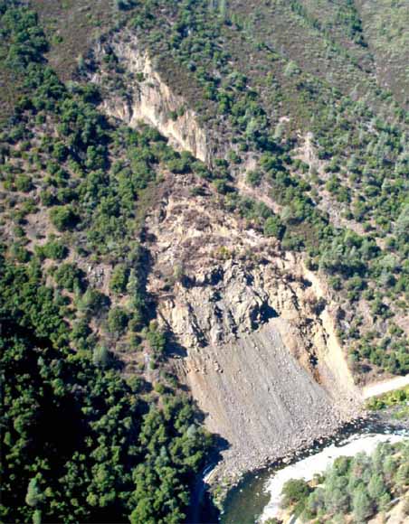
Looking northwest, of the east-facing Ferguson Rockslide, Merced River, with the talus covering Highway 140. Photograph by Mark Reid, US Geological Survey (from figure 1).
An active rockslide in Merced River Canyon was first noticed on April 29, 2006 when a few rocks rolled onto Highway 140 between mileposts 103 and 104, compromising traffic on this highway and signaling the onset of renewed activity of the Ferguson rockslide. State highway 140 is one of the main entrances to Yosemite National Park and is the primary road for large commercial trucks access into the park from the west. Continued rockslide activity during 2006 built a large talus cone that covered the highway and encroached into the Merced River below it. Observations by the US Forest Service (USFS), the California Department of Transportation (CALTRANS), and the U.S. Geological Survey (USGS) confirm that the rockslide remained active through 2006 and represents a potential threat to traffic along the rerouted highway as well as to recreational users of the Merced River in the runout path below the rockslide. Delineation of the hazards posed by the Ferguson rockslide is a necessary prerequisite to mitigating them.
Field observations of the rockslide, shown in the photo of Figure 1, have constrained the geometry and structure of the slide mass (Beck, 2006; Gallegos and DeGraff, 2006). Based on initial estimates by geologists from USFS, CALTRANS and the USGS, the rockslide, active in 2006 and 2007, has an area of approximately 40,000 square meters and a volume of approximately 800,000 cubic meters. Structural mapping suggests that the motion of the slide is translational along a planar bed, and that differential motion of the slide from the toe to the headwall has resulted in formation of large tension cracks that transect the slide across the slope (Beck, 2006). These indications of persistent movement were confirmed during 2006 and 2007 by GPS measurements made by the USGS at three points on the rockslide (Rick LaHusen, USGS, written communication). The larger of these cracks divide the slide into regions that moved at different rates in 2006, with the toe of the rockslide moving five to ten times faster than the middle portion or headwall part of the slide. Downslope of the main rockslide mass, a talus slope consist in of angular blocks ranging in size from 0.1 to greater than 10 meters (Gallegos and DeGraff, 2006), buries Highway 140. Both the main rockslide and the talus consist of angular blocks ranging in size from 0.1 to more than 10 meters and are composed of highly fractured phyllite, slate, and chert from the Phyllite and Chert of Hite Cove (Bateman and Krauskopf, 1987).
The purpose of this report is to assess the hazard posed by the Ferguson rockslide by simulating the runout and deposition of a portion of the slide if rapid failure occurs. As discussed by Gallegos and DeGraf (2006), a runout analysis is needed to delineate slide hazards. The report is restricted to calculations of potential runout and does not address the likelihood of rapid failure. Based on discussions with Allan Gallegos (USFS), two end-member initial slide volumes were chosen: (1) the toe of the slide along boundaries defined by Tim Beck (CALTRANS) in (Beck, 2006), and (2) the entire sliding rock mass, again along boundaries defined by Tim Beck. The simulated runout of these volumes during rapid failure uses granular flow mechanics developed by Iverson (1997) and the model developed by Denliner and Iverson, (2004). This model has been thoroughly tested against experimental data and provides plausible, defensible results.
Download this report as a 25-page PDF file (of2007-1275.pdf; 1.3 MB).
For questions about the content of this report, contact Roger Denlinger
Suggested citation and version history
Download a copy of the latest version of Adobe Reader for free.
|
Help |
PDF help |
Publications main page |
| Western Open-File Reports for 2007 |
| Geologic Division | Landslide Hazards Program

![]() U.S. Department of the Interior | U.S. Geological Survey
U.S. Department of the Interior | U.S. Geological Survey
URL: https://pubs.usgs.gov/of/2007/1275/
Page Contact Information: Michael Diggles
Page Last Modified: October 15, 2007