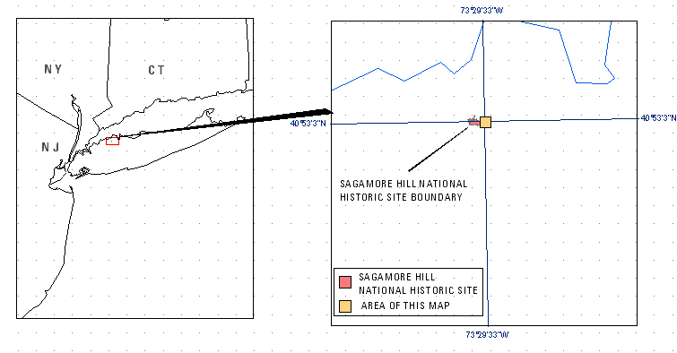
USGS-NPS-NASA EAARL Topography

LIDAR Illustration

Home

Purpose Link

PDF Maps Link

Raw Data Link

ArcMap Document Link

Metadata Link

Collaborators Lilnk

Open-File Report 2007-1394


EAARL Topography-Sagamore Hill National Historic Site

John C. Brock1, C. Wayne Wright2, Amar Nayegandhi3, Matt Patterson4, and Laurinda J. Travers5

1USGS, FISC St.Petersburg, FL, 2NASA,Wallops Flight Facility, Wallops Island, VA, 3ETI Professionals, USGS, St. Petersburg, FL 4NPS, South Florida/Caribbean Network Inventoryand Monitoring Program, Miami, FL, 5Eckerd College, USGS, St. Petersburg, FL


This Web site contains lidar-derived bare earth (BE) and first return (FR) topography maps and GIS files for the Sagamore Hill National Historic Site.

Click on one of the links below to view the corresponding map tile as a PDF file.

To expedite download times and to prevent any possible errors, right click on the desired PDF map tile and save the file to disk. If you require all of the map tiles or would like a copy of the Open-File Report in DVD format, please contact: Emily Klipp in the USGS, FISC St. Petersburg office: eklipp@usgs.gov

  • Tile 1 BE (Quad 626000e_4528000n)
  • Tile 1 FR (Quad 626000e_4528000n)


  • To view a tile as a PDF file, download a free copy of Adobe Reader:    Get Adobe Reader Link

    Accessibility FOIA Privacy Policies and Notices

    Take Pride in America home pageFirstGov LinkU.S. Department of the Interior | U.S. Geological Survey
    URL: http://pubsdata.usgs.gov/pubs/of/2007/1394/start.html
    For more information, contact: Feedback
    Maintained by Publishing Service Center
    Page Last Modified: Wednesday, 07-Dec-2016 20:37:27 EST