

U.S. Geological Survey Open-File Report 2008-1121
Modified Mercalli Intensity Maps for the 1868 Hayward Earthquake Plotted in ShakeMap Format
By John Boatwright and Howard Bundock
|
|
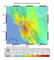
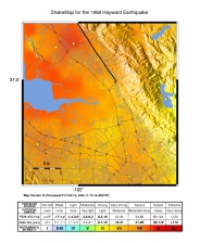
MMI ShakeMap of Central California for the 1868 Hayward earthquake by Boatwright and Bundock (2008) | JPEGs | Contours and Grids | Metadata | Postscript | Shapefiles | Station Lists |
|
|
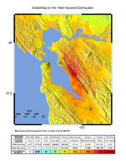
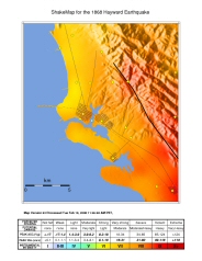
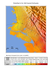
MMI ShakeMap of the San Francisco Bay Area with 1868 Coastline and Roads for the 1868 Hayward earthquake by Boatwright and Bundock (2008) | JPEGs | Contours and Grids | Metadata | Postscript | Shapefiles | Station Lists |
|
|
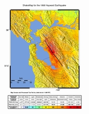
MMI ShakeMap of the San Francisco Bay Area with Current Coastline and Roads for the 1868 Hayward earthquake by Boatwright and Bundock (2008) | JPEGs | Contours and Grids | Metadata | Postscript | Shapefiles | Station Lists |
|
|
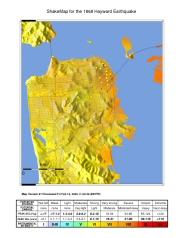
MMI ShakeMap of San Francisco with 1868 Coastline and Roads for the 1868 Hayward earthquake by Boatwright and Bundock (2008) | JPEGs | Contours and Grids | Metadata | Postscript | Shapefiles | |
|
|
MMI ShakeMap of San Francisco with Current Coastline and Roads for the 1868 Hayward earthquake by Boatwright and Bundock (2008) | JPEGs | Contours and Grids | Metadata | Postscript | Shapefiles | |
|
|
MMI ShakeMap of Oakland with 1868 Coastline and Roads for the 1868 Hayward earthquake by Boatwright and Bundock (2008) | JPEGs | Contours and Grids | Metadata | Postscript | Shapefiles | |
|
|
MMI ShakeMap of Oakland with Current Coastline and Roads for the 1868 Hayward earthquake by Boatwright and Bundock (2008) | JPEGs | Contours and Grids | Metadata | Postscript | Shapefiles | |
|
|
MMI ShakeMap of Hayward with 1868 Coastline and Roads for the 1868 Hayward earthquake by Boatwright and Bundock (2008) | JPEGs | Contours and Grids | Metadata | Postscript | Shapefiles | |
|
|
MMI ShakeMap of Hayward with Current Coastline and Roads for the 1868 Hayward earthquake by Boatwright and Bundock (2008) | JPEGs | Contours and Grids | Metadata | Postscript | Shapefiles | |
|
|
MMI ShakeMap of San Jose with 1868 Coastline and Roads for the 1868 Hayward earthquake by Boatwright and Bundock (2008) | JPEGs | Contours and Grids | Metadata | Postscript | Shapefiles | |
|
|
MMI ShakeMap of San Jose with Current Coastline and Roads for the 1868 Hayward earthquake by Boatwright and Bundock (2008) | JPEGs | Contours and Grids | Metadata | Postscript | Shapefiles | |
|
|
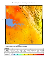
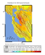
MMI ShakeMap of San Francisco Bay Area for the 1868 Hayward earthquake for Comparison with 1989 Loma Prieta earthquake | JPEGs | Contours and Grids | Metadata | Postscript | Shapefiles | |
|
|
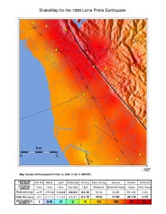
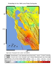
MMI ShakeMap of San Francisco Bay Area for the 1989 Loma Prieta earthquake for Comparison with 1868 Hayward earthquake | JPEGs | Contours and Grids | Metadata | Postscript | Shapefiles |
Back to - U.S. Geological Survey Open-File Report 2008-1121
Modified Mercalli Intensity Maps for the 1868 Hayward Earthquake Plotted in ShakeMap Format