
U.S. Geological Survey
Open-File Report
2008-1121
Version 1.0
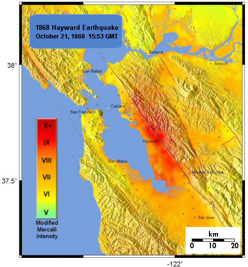
Modified Mercalli Intensity Maps for the 1868 Hayward Earthquake Plotted in ShakeMap Format
By John Boatwright and Howard Bundock
2008
This website presents Modified Mercalli Intensity maps for the Hayward earthquake of October 21, 1868.
Summary Report
MMI Intensity Maps
Spreadsheet of 1868 Intensity Sites
Resistance of Pioneer Masonry and Mexican Adobe Structures
Inferring Shaking Intensities at Cemeteries that have Suffered Multiple Damaging Earthquakes
Descriptions of Damage and Felt Reports for All Sites
References
Downloads
For questions about the content of this report, contact Jack Boatwright.
Version history
| Help
| PDF help
| Publications main page | Open-File
Reports for 2008 |
| Privacy
Statement | Disclaimer
| Accessibility |
| Geologic Division |
Earthquake Hazards Program
|
This report is available only on the Web
| Department of the Interior
| U.S. Geological Survey |
URL of this page: https://pubs.usgs.gov/of/2008/1121/
Maintained by: Michael Diggles
Date created: April 15, 2008
Date last modified: July 12, 2011
(mfd)