Western Mineral Resources
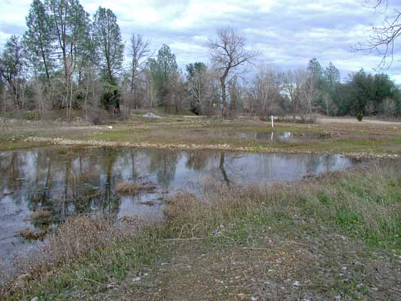
Wetlands ponds constructed on an alluvial terrace previously mined for placer gold, Old Mill area, lower Clear Creek. USGS Photograph by R.P. Ashley, January 2003.
Clear Creek, one of the major tributaries of the upper Sacramento River, drains the eastern Trinity Mountains. Alluvial plain and terrace gravels of lower Clear Creek, at the northwest edge of the Sacramento Valley, contain placer gold that has been mined since the Gold Rush by various methods including hydraulic mining and dredging. In addition, from the 1950s to the 1980s aggregate-mining operations removed gravel from the lower Clear Creek flood plain.
Since Clear Creek is an important stream for salmon production, a habitat restoration program is underway to repair damage from mining and improve conditions for spawning. This program includes moving dredge tailings to increase the area of spawning gravel and to fill gravel pits in the flood plain, raising the concern that mercury lost to these tailings in the gold recovery process may be released and become available to biota. The purposes of our study are to identify sources, transport, and dispersal of mercury in the lower Clear Creek area and identify environments in which bioavailable methylmercury is produced. Analytical data acquired include total mercury and methylmercury concentrations in sediments, tailings, and water.
Mercury concentrations in bedrock and unmined gravels in and around the mined area are low and are taken to represent background concentrations. Bulk mercury values in placer mining tailings range from near-background in coarse dry materials to more than 40 times background in sands and silts exposed to mercury in sluices. Tailings are entrained in flood-plain sediments and active stream sediments; consequently, mercury concentrations in these materials range from background to about two to three times background. Mercury in sediments and tailings is associated with fine size fractions. The source of most of this mercury is historical gold mining in the Clear Creek watershed. Although methylmercury levels are low in most of these tailings and sediments, flood-plain sediment in shallow flood-plain ponds, tailings in a dredge pond, and active stream sediment in a Clear Creek backwater have elevated levels of methylmercury.
Stream waters in the area show low mercury levels during both summer and winter base-flow conditions. During winter high flows total mercury increases by about one order of magnitude; this additional mercury is associated with suspended particulate material. Methylmercury is low in stream waters.
Ponds in various environments generally have higher total mercury levels in waters than Clear Creek under base-flow conditions and higher methylmercury levels in both sediments and waters. Ponds are probably the main source of bioavailable mercury in the lower Clear Creek area.
Several saline springs occur in the area. The saline waters are enriched in lithium, boron, and mercury, similar to connate waters that are expelled along thrust faults to the south on the west side of the Sacramento Valley. Saline springs may locally contribute some mercury to pond and drainage waters.
Download this report as a 73-page PDF file (of2008-1122.pdf; 54.4 MB). This file contains only links to figure 2 and the tables (also linked below)
Download figure 2 for this report as a 1-page, ~28" x 13" PDF file (of2008-1122_fig02.pdf; 320 kB).
Go to the Tables folder where the data are available in .xls, .doc, .pdf, .csv, and (or) .txt formats (tables folder; 20 files that total 1.6 MB).
Download shapefile based on table 1.
Read the metadata (text file).
For questions about the content of this report, contact Roger Ashley or Jim Rytuba
Suggested citation and version history
Download a free copy of the current version of Adobe Reader.
| Help
| PDF help
| Publications | Western Open-File Reports for 2008 |
| Geology Disipline | Western Mineral Resources
|
This report is availalbe only on the Web

![]() U.S. Department of the Interior | U.S. Geological Survey
U.S. Department of the Interior | U.S. Geological Survey
URL: https://pubs.usgs.gov/of/2008/1122/
Page Contact Information: Michael Diggles
Page Created: July 31, 2008
Page Last Modified: October 6, 2008