

|
|
Coastal and Marine Geology Program
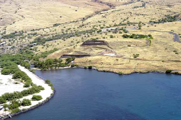
Oblique aerial photograph showing Pu‘ukoholā Heiau (upper structure) and Mailikini Heiau (lower structure) and surrounding areas at Pu‘ukoholā Heiau National Historic Site. The coastal engineering structure in the lower left is part of the Kawaihae Harbor revetment. View towards the east. Photograph courtesy of Brian Powers, Hawaiian Images Photography and Video, Kailua Kona, Hawaii.
Geologic resource inventories of lands managed by the National Park Service (NPS) are important products for the parks and are designed to provide scientific information to better manage park resources. Park-specific geologic reports are used to identify geologic features and processes that are relevant to park ecosystems, evaluate the impact of human activities on geologic features and processes, identify geologic research and monitoring needs, and enhance opportunities for education and interpretation. These geologic reports are planned to provide a brief geologic history of the park and address specific geologic issues forming a link between the park geology and the resource manager.
The Kona coast National Parks of the Island of Hawai‘i are intended to preserve the natural beauty of the Kona coast and protect significant ancient structures and artifacts of the native Hawaiians. Pu‘ukoholā Heiau National Historic Site (PUHE), Kaloko-Honokōhau National Historical Park (KAHO), and Pu‘uhonua O Hōnaunau National Historical Park (PUHO) are three Kona parks studied by the U.S. Geological Survey (USGS) Coastal and Marine Geology Team in cooperation with the National Park Service. This report is one of six related reports designed to provide geologic and benthic-habitat information for the three Kona parks. Each geology and coastal-landform report describes the regional geologic setting of the Hawaiian Islands, gives a general description of the geology of the Kona coast, and presents the geologic setting and issues for one of the parks. The related benthic-habitat mapping reports discuss the marine data and habitat classification scheme, and present results of the mapping program.
Pu‘ukoholā Heiau National Historic Site (PUHE) is the smallest (~86 acres) of three National Parks located on the leeward Kona coast of the Island of Hawai‘i. The main structure at PUHE, Pu‘ukoholā Heiau, is an important historical temple that was built during 1790-91 by King Kamehameha I (also known as Kamehameha the Great) and is often associated with the founding of the Hawaiian Kingdom (Greene, 1993). The temple was constructed to incur the favor of the king’s personal war god Kūkā‘ilimoku during the time that Kamehameha I waged several battles in an attempt to extend his control over all the Hawaiian Islands. The park is also the site of the older Mailekini Heiau, which was used by the ancestors of Kamehameha I, and an offshore, submerged temple, Hale O Kapuni Heiau, that was dedicated to the shark god. The park occupies the scenic Hill of the Whale overlooking Kawaihae Bay and Pelekane Beach.
The seaward-sloping lands of PUHE lie at the convergence of lava flows formed by both Mauna Kea and Kohala Volcanoes. The park coastline is mostly rocky, with the exception of a small beach developed at the north boundary where an intermittent stream enters the sea. The park is bounded to the north by Kawaihae Harbor, to the south by Samuel M. Spencer Beach Park, and to the west by a broad submerged reef. The adjacent reef area is discussed in detail in the accompanying report by Cochran and others (2006). They mapped from the shoreline to depths of approximately 40 m, where the shelf drops off to a sand-covered bottom. PUHE park boundaries extend only to the mean high-tide line, however, landscape impacts created by development around the park are of concern to Park management.
Download this report as a 30-page PDF file (of2008-1190.pdf; 13.1 MB).
USGS Scientific Investigations Report 2006-5254, Geologic Resource Evaluation of Pu‘ukoholā Heiau National Historic Site, Hawai‘i; Part II: Benthic Habitat Mapping by Susan A. Cochran, Ann E. Gibbs, and Joshua B. Logan
For questions about the content of this report, contact Bruce Richmond
Download a free copy of the latest version of Adobe Reader.
|
Help |
PDF help |
Publications main page |
| Western Open-File Reports for 2008 |
| Geography | Coastal and Marine Geology
|

![]() U.S. Department of the Interior | U.S. Geological Survey
U.S. Department of the Interior | U.S. Geological Survey
URL: https://pubs.usgs.gov/of/2008/1190/
Page Contact Information: Michael Diggles
Page Created: February 10, 2009
Page Last Modified: February 18, 2009