U.S. Geological Survey Open-File Report 2008-1196
Enhanced Sidescan-Sonar Imagery Offshore of Southeastern Massachusetts
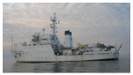
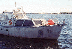
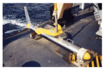
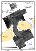
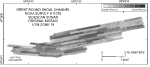
Data Acquisition The raw sidescan-sonar data used to produce the reprocessed imagery presented in this report were collected during two surveys in 2004 aboard the NOAA Ship Thomas Jefferson (fig. 2). During the Quicks Hole survey (H11076), two 29-foot launches deployed from the Thomas Jefferson were used to acquire the backscatter data over the approximately 22.9-km² survey area along 557 km of survey lines. These sidescan-sonar data were acquired with a hull-mounted Klein 5000 system operating at 455 kHz (figs. 3, 4). During the Great Round Shoal Channel survey (H11079), the data were acquired by the Thomas Jefferson with a towed Klein 5000 system (fig. 5), also operating at 455 kHz. These data, which were collected over an approximately 17.1-km² area along roughly 106 km of survey lines, were acquired only over the eastern part of this survey area due to time and water-depth limitations. The sidescan-sonar data were acquired in XTF (extended Triton data format) and recorded digitally through an ISIS data-acquisition system. For a more complete discussion of the acquisition methods, readers are encouraged to consult the original descriptive reports (National Oceanic and Atmospheric Administration, 2004a, b). Data Processing The sidescan-sonar data were processed by using CARIS SIPS (Sidescan Image Processing System) software for quality control, multiplexing and filtering, correcting for slant-range distortions, and producing continuous sidescan-sonar mosaics. Horizontal resolution of the sidescan-sonar data in both datasets is 1 m. This sidescan-sonar imagery was also enhanced to increase the dynamic range of the data, invert the grayscale, and reproject the data onto geographic coordinates (Poppe and others, 2007a, b). Unfortunately, the original mosaics contained numerous tonal artifacts caused by variable equipment settings (for example, power and gain changes), processing techniques (for example, inaccurate cross-track and line-to-line normalization or failure to overwrite the 16-bit shift factor in CARIS), and environmental conditions (for example, sea state). These artifacts obscure the true backscatter trends and give these mosaics a quilt-like patchwork appearance (figs. 6, 7). Although the original XTF sidescan-sonar data files from these NOAA surveys were obtained in order to reprocess the data and minimize the tonal artifacts, we were unable to minimize artifacts and produce mosaics successfully by using our processing tools (Xsonar and ShowImage; Danforth, 1997) to improve the resolution of backscatter trends representative of the true sea-floor geology. Therefore, to remove or minimize the appearance of these tonal artifacts, the mid-tonal-range lines that composed the majority of the mosaics were selected as a baseline. Adjacent lines that were of an unnatural and abruptly different tone were adjusted toward the tone of the baseline by tracing the perimeter of the line with the Polygon Lasso Tool and then matching tones to the adjacent lines with the shadow, mid-tone, and highlight input sliders in the Levels dialog box of Adobe Photoshop 7.0. Lines that were too light, based on the tones of adjacent lines and the bottom-sampling and photographic-verification data (Poppe and others, 2007a, b), were darkened; lines that were too dark were lightened. The Spot Healing Brush Tool was also used in several places to eliminate small artifacts within a sonar line. The result is a continuous grayscale spectrum that reflects the character of the sea floor without the artifacts that were present in the original mosaics. Lighter backscatter tones in the enhanced sidescan-sonar imagery are now predominantly caused by stronger acoustic returns and tend to reflect coarser sediments. Darker backscatter tones are now predominantly caused by weaker acoustic returns and tend to reflect finer sediments. The enhanced TIFF images were subsequently reunited with their world (.tfw) files and reconverted back to GeoTIFFs with the program GeoTiffExamine. |
|

![]() U.S. Department of the Interior |
U.S. Geological Survey
U.S. Department of the Interior |
U.S. Geological Survey
URL: http://pubsdata.usgs.gov/pubs/of/2008/1196/html/methods.html
Page Contact Information: GS Pubs Web Contact
Page Last Modified: Wednesday, 07-Dec-2016 21:37:08 EST