U.S. Geological Survey Open-File Report 2008-1196
Enhanced Sidescan-Sonar Imagery Offshore of Southeastern Massachusetts
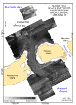
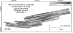
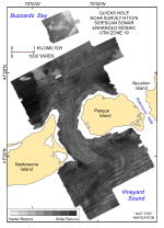
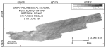
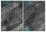
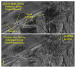
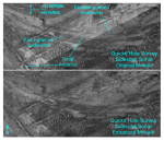
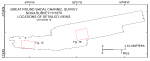
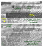
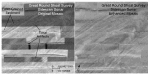
Sidescan-sonar imagery produced from data collected during NOAA hydrographic surveys has previously been published in several digital reports that described characteristics of the sea-floor and interpreted the surficial geologic processes offshore of southeastern Massachusetts (Poppe and others, 2007a, b; 2008). Unfortunately, the mosaics from two of these surveys (Quicks Hole: Poppe and others, 2007a; Great Round Shoal Channel: Poppe and others, 2007b) contain numerous tonal artifacts (figs. 6, 7). Because the adjacent sidescan-sonar lines within these two datasets are not tonally matched, interpretations are complicated, the geology and general backscatter characteristics are obscured, and the mosaics have an unnatural, quilt-like patchwork appearance. Enhancing the imagery from these surveys has corrected, or at least minimized, many of the false backscatter tonal changes, such as those related to inaccurate line-to-line normalization and environmental factors. Thus, this enhancement produces mosaics that accentuate the geology and more accurately represent the actual backscatter trends that reflect the distribution of surficial sediments (figs. 8, 9). For example, distinctive tonal patterns revealed on these sidescan-sonar mosaics include (1) alternating bands of high and low backscatter arranged in a “tiger-stripe” pattern, (2) complex patches of high and low backscatter with individual high-backscatter targets (objects), (3) areas of relatively high backscatter (light tones), and (4) areas of relatively low backscatter (dark tones). Quicks Hole Imagery “Tiger-stripe” backscatter patterns, which are produced by sand waves, result from a combination of topographic changes affecting the angle of incidence of the sidescan sonar and differences in sediment texture commonly present between crests and troughs of sand waves (Reineck and Singh, 1980). For example, sand waves across the southern part of the Quicks Hole survey are characterized by processes associated with coarse bedload transport (Poppe and others, 2007a). A comparison of detailed views of the original and enhanced sidescan-sonar mosaics from this area demonstrates how enhancement has improved resolution of the character and distribution of these bedforms (figs. 10, 11). Textural data (Poppe and others 2007a) also show that the dominant sediment grain size in the sand-wave field is medium sand (greater than or equal to 2.0 phi, but less than 1.0 phi; Wentworth, 1922; fig. 11) and that the minor textural variations in the sediment collected from different stations do not support the abrupt changes in backscatter between adjacent lines in the original imagery. The complex patches of high and low backscatter with individual high-backscatter targets reveal rocky and bouldery areas. In the Quicks Hole survey, these areas are exposures of the Buzzards Bay moraine and are concentrated along shorelines around Pasque and Nashawena Islands, on the crests of bathymetric highs, and within the passage itself (Oldale, 2001; Poppe and others, 2007a). A comparison of equivalent detailed views of the original and enhanced sidescan-sonar mosaics from the northwestern entrance to the Quicks Hole passage shows how removal of the tonal artifacts accentuates resolution of the boulder-field distributions (fig. 12). Higher backscatter tends to be produced by coarser-grained sediments, typically gravel and gravelly sand. Narrow elongate patches characterized by relatively low backscatter are commonly scattered within the areas of high backscatter at the southeastern entrance to the Quicks Hole passage. These curved patches of low backscatter trend west-northwest toward the passage, are produced by finer grained Holocene sand, and reflect the strength of and transport by oscillating tidal currents (Poppe and others, 2007a). A comparison of detailed views of the original and enhanced sidescan-sonar mosaics from this area shows how image enhancement has accentuated these features (fig. 13). Great Round Shoal Channel Imagery The presence of a “tiger-stripe” backscatter pattern indicates that sand waves also occur across the western part of the Great Round Shoal Channel survey. A comparison of detailed views of the original and enhanced sidescan-sonar mosaics from this area illustrates how enhancement has improved the continuous grayscale perspective of the imagery (figs. 14, 15). Although textural data (Poppe and others, 2007b) show that sediment-grain size within this sand-wave field ranges from coarse to medium sand, these minor textural variations in the sediment collected from different stations do not support the abrupt changes in backscatter between adjacent lines in the original imagery (fig. 15). Furthermore, the mean sediment grain size at station GRS26 is coarser (0.81 phi) than at station GRS22 (1.69 phi), yet the backscatter in the vicinity of GRS26 is of darker tone in the original mosaic (fig. 15). Narrow elongate patches characterized by relatively low backscatter are also commonly scattered within the areas of high backscatter in the eastern part of the Great Round Shoal Channel survey. These patches of low backscatter trend northeast, are produced by finer grained Holocene sand, and give the sea floor a current-swept appearance (Poppe and others, 2007b). Tonal changes of backscatter within these patches are important because they reflect subtle variations in sediment texture and sedimentary environment. A comparison of detailed views of the original and enhanced sidescan-sonar mosaics from this area shows how image enhancement has accentuated these trends and distributions (fig. 16). |
|

![]() U.S. Department of the Interior |
U.S. Geological Survey
U.S. Department of the Interior |
U.S. Geological Survey
URL: http://pubsdata.usgs.gov/pubs/of/2008/1196/html/sidescan.html
Page Contact Information: GS Pubs Web Contact
Page Last Modified: Wednesday, 07-Dec-2016 21:37:09 EST