Earthquake Hazards Program
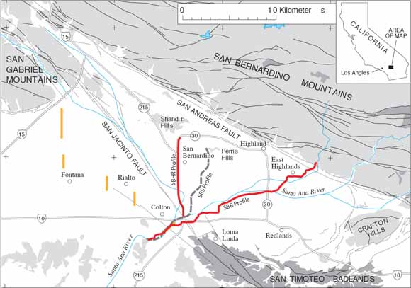
Map of the San Bernardino area showing the locations of seismic profiles relative to known geologic structures, major roadways, and various cities (from figure 1).
In this report, we present seismic data and acquisition parameters for two seismic profiles acquired in the San Bernardino, California area in May and October 2003. We refer to these seismic profiles as the San Bernardino Regional (SBR) and San Bernardino High-Resolution (SBHR) seismic profiles. We present both un-interpreted and interpreted seismic images so that the structure of the area can independently interpreted by others. We explain the rationale for our interpretations within the text of this report, and in addition, we provide a large body of supporting evidence.
The SBR seismic profile extended across the San Bernardino Basin approximately N30°E from the town of Colton to the town of Highland. The data were acquired at night when the signal-to-noise ratios were reasonably good, and for the larger shots, seismic energy propagated across the ~20-km-long array. Tomographic velocity data are available to depths of about 4 km, and low-fold reflection data are available to depths in excess of 5 km. The SBR seismic data reveal an asymmetric, fault-bound basin to about 5 km depth.
The SBHR seismic profile trended along the I-215 freeway from its intersection with the Santa Ana River to approximately State Road 30 in San Bernardino. Seismic data acquired along the I-215 freeway provide detailed images, with CDP spacing of approximately 2.5 m along an approximately 8.2-km-long profile; shot and geophone spacing was 5 m. For logistical reasons, the high-resolution (SBHR) seismic data were acquired during daylight hours on the shoulder of the I-215 freeway and within 5 to 10 m of high-traffic volumes, resulting in low signal-to-noise ratios. The limited offset at which refracted first-arrivals could be measured along the SBHR seismic profile limited our measurements of tomographic refraction velocities to relatively shallow (< 150 m) depths. The SBHR reflection data reveal a basin with complex structural details within the upper kilometer.
The two seismic profiles show internal consistency and consistency with other existing geophysical data. Collectively, the data suggest that the I-215 freeway trends along the faulted edge of a pull-apart basin, within a zone where the principal slip of the San Jacinto Fault is transferred to the San Andreas Fault. Because the I-215 freeway trends at low angles to these flower-structure faults, both primary and numerous secondary faults are apparent between the I-10 exchange and State Road-30, suggesting that much of the 8-km-long segment of the I-215 freeway could experience movement along primary or secondary faults.
Download this report as a 129-page PDF file (of2008-1197.pdf; 133 MB).
For questions about this report, contact Rufus Catchings.
Suggested citation and version history
Download a free copy of the current version of Adobe Reader.
| Help | PDF help | Publications main page | Western Open-File Reports for 2008 |
| Geology | Earthquake Hazards Program |
This report is available only on the Web

![]() U.S. Department of the Interior | U.S. Geological Survey
U.S. Department of the Interior | U.S. Geological Survey
URL: https://pubs.usgs.gov/of/2008/1197/
Page Contact Information: Michael Diggles
Page Last Modified: June 13, 2008
(mfd)