U.S. Geological Survey Open-File Report 2008-1206
Coastal Change Along the Shore of Northeastern South Carolina: The South Carolina Coastal Erosion Study
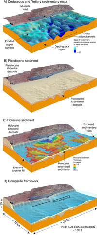
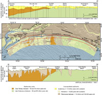
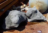
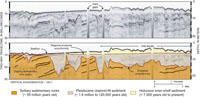
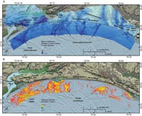
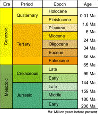
3.1 IntroductionThe Grand Strand geologic framework consists of an ancient sedimentary-rock foundation that is overlain by younger unconsolidated sediment (Figure 3.1). Unconsolidated sediments measure up to 30 m (99 ft) thick landward of the shoreline, but thin significantly in offshore areas. Modern sediment is largely absent across much of the shallow seafloor of Long Bay, and exposures of older sedimentary rock are common (Figure 3.2). The framework components have been eroded to various degrees, and their remains provide a fragmented geologic record that spans about 70 million years (Table 3.1). 3.2 Framework ComponentsCretaceous and Tertiary Sedimentary Rocks The layered succession of sedimentary rocks underlying the region was deposited between about 70 and 55 million years ago during the Cretaceous and Tertiary Periods (Table 3.1; Figure 3.1a). Fossilized remains of marine organisms indicate that the rocks were originally deposited as sandy and muddy sediment in continental-shelf settings. Over time, a combination of biochemical and geochemical processes cemented the loose particles of sediment together to form sandstones, siltstones, and mudstones (Figure 3.3). Erosion has sharply truncated the rocks since their deposition and created a broad, low-relief surface that slopes gently seaward across the region. Locally, rivers and streams eroded deep channels into the rocks during times of lower sea level (Figures 3.2 and 3.4). These paleochannels differ in size and shape (Figure 3.5a), indicating that they were formed by different types of fluvial systems, including large rivers, smaller tributaries, marsh creeks, and tidal inlets. The eroded upper surface of the rocks represents an unconformity, which is a gap in the geologic record caused by a combination of erosion and nondeposition. The unconformity represents a time span of about 70 million years in locations where Cretaceous rocks crop out on the seafloor (Figure 3.2). Pleistocene Sediment After the long hiatus represented by the unconformity, sediments began to accumulate on top of the eroded sedimentary rocks about 1.8 million years ago during the Pleistocene Epoch (Table 3.1; Figure 3.1b). Deeply-buried Pleistocene sediments consisting of sands and gravels fill the network of paleochannels incised into the underlying foundation. These channel-fill deposits are truncated by a second regionally extensive erosional unconformity which has formed in part during the ongoing rise in sea level (Figures 3.2 and 3.4). Pleistocene sediments also compose ancient shoreline deposits that form the coastal upland landward of Grand Strand beaches (Figure 1.6). These shoreline deposits consist of sediments that accumulated in ancient salt-marsh, estuarine, dune, beach, barrier-island, tidal-inlet, and nearshore-marine settings, and their preservation is irregular along the coast (Figure 3.2). South of Surfside Beach, the old shoreline deposits are relatively well preserved landward of modern barrier systems such as North, Debordieu, and Pawleys Islands. To the north however, where no protective barriers exist, they have been eroded landward of the shoreline. Storm-related erosion periodically exposes semi consolidated parcels of the shoreline deposits on the beach and upper shoreface, where they form low-relief pavements in places like Hurl Rocks State Park. Holocene Sediment The modern coastal system includes shoreline and inner-shelf sediment that is actively moved by waves and currents. These mobile, generally sandy deposits are composed of Holocene sediment that has been accumulating since about 7,000 years ago (Figure 3.1c). They lie above the regionally extensive erosional unconformity (Figures 3.2 and 3.4), which makes them easily distinguishable from older underlying rocks and channel fills. Holocene shoreline deposits are distributed unevenly in a narrow wedge along the coast (Figure 3.2). South of Murrells Inlet and north of North Myrtle Beach, relatively thick and wide accumulations form salt marshes, barrier islands, and spits that lie seaward of the Pleistocene upland. No barrier islands exist along the Myrtle Beach section of the coast, where limited amounts of Holocene sediment form thin, narrow beaches that are directly attached to the eroded mainland. The wedge of Holocene beach sediment thins seaward and forms a discontinuous veneer on the shoreface and inner shelf of Long Bay. Holocene sediments are less than 0.5 m (1.7 ft) thick or absent across most of the inner shelf (an area of about 530 km2 or 205 mi2); as a result the seafloor largely consists of broad exposures of older rocks and channel-fill deposits (Figures 3.2 and 3.5b). Inner-shelf sediments generally increase in abundance toward the southwest. The thickest accumulations (up to 6 m or 20 ft) primarily form low-relief linear ridges and shoal complexes that lie seaward of modern tidal inlets and estuaries, including Little River Inlet, Hog Inlet, Murrells Inlet, Pawleys Inlet, North Inlet, and Winyah Bay. Next Section: 3.3 Evolution of the Geologic Framework » |

 U.S. Department of the Interior |
U.S. Geological Survey
U.S. Department of the Interior |
U.S. Geological Survey
URL: https://pubsdata.usgs.gov/pubs/of/2008/1206/html/framework1.html
Page Contact Information: Publishing Service Center
Page Last Modified: Monday, 03-Jun-2019 11:36:37 EDT