Earthquake Hazards Program
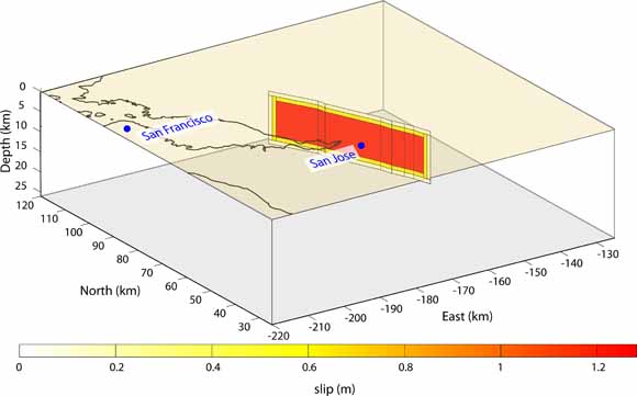
Example slip distribution for the Northern Calaveras M 6.78 scenario earthquake (from figure 1)
In the immediate aftermath of a major earthquake, the U.S. Geological Survey (USGS) will be called upon to provide information on the characteristics of the event to emergency responders and the media. One such piece of information is the expected surface displacement due to the earthquake. In conducting probabilistic hazard analyses for the San Francisco Bay Region, the Working Group on California Earthquake Probabilities (WGCEP) identified a series of scenario earthquakes involving the major faults of the region, and these were used in their 2003 report (hereafter referred to as WG03) and the recently released 2008 Uniform California Earthquake Rupture Forecast (UCERF). Here I present a collection of maps depicting the expected surface displacement resulting from those scenario earthquakes.
The USGS has conducted frequent Global Positioning System (GPS) surveys throughout northern California for nearly two decades, generating a solid baseline of interseismic measurements. Following an earthquake, temporary GPS deployments at these sites will be important to augment the spatial coverage provided by continuous GPS sites for recording postseismic deformation, as will the acquisition of Interferometric Synthetic Aperture Radar (InSAR) scenes. The information provided in this report allows one to anticipate, for a given event, where the largest displacements are likely to occur. This information is valuable both for assessing the need for further spatial densification of GPS coverage before an event and prioritizing sites to resurvey and InSAR data to acquire in the immediate aftermath of the earthquake. In addition, these maps are envisioned to be a resource for scientists in communicating with emergency responders and members of the press, particularly during the time immediately after a major earthquake before displacements recorded by continuous GPS stations are available.
Download this report as a 44-page PDF file (of2008-1375.pdf; 4.7 MB).
Download the 35 ASCII Coulomb 3 input files as a .zip archive. These enable others to generate more detailed plots or to modify source parameters (for instance to allow for greater near-surface slip) (of2008-1375_ElectronicSupplement.zip; 48 kB compressed, 360 kB expanded).
For questions about this report, contact Jessica Murray-Moraleda.
Suggested citation and version history
Download a free copy of the latest version of Adobe Reader.
| Help | Publications main page | Western Open-File Reports for 2008 |
| Geology | Earthquake Hazards Program |
This report is available only on the Web

![]() U.S. Department of the Interior | U.S. Geological Survey
U.S. Department of the Interior | U.S. Geological Survey
URL: https://pubs.usgs.gov/of/2008/1375/
Page Contact Information: Michael Diggles
Page Created: February 18, 2009
Page Last Modified: February 18, 2009
(mfd)