Open-File Report 2009–1028
INTRODUCTIONLand-use and land-cover (LULC) data provide important information for environmental management. Data pertaining to land-cover and land-management activities are a common requirement for spatial analyses, such as watershed modeling, climate change, and hazard assessment. In coastal areas, land development, storms, and shoreline modification amplify the need for frequent and detailed land-cover datasets. The northern Gulf of Mexico coastal area is no exception. The impact of severe storms, increases in urban area, dramatic changes in land cover, and loss of coastal-wetland habitat all indicate a vital need for reliable and comparable land-cover data. Four main attributes define a land-cover dataset: the date/time of data collection, the spatial resolution, the type of classification, and the source data. The source data are the foundation dataset used to generate LULC classification and are typically remotely sensed data, such as aerial photography or satellite imagery. These source data have a large influence on the final LULC data product, so much so that one can classify LULC datasets into two general groups: LULC data derived from aerial photography and LULC data derived from satellite imagery. The final LULC data can be converted from one format to another (for instance, vector LULC data can be converted into raster data for analysis purposes, and vice versa), but each subsequent dataset maintains the imprint of the source medium within its spatial accuracy and data features. The source data will also influence the spatial and temporal resolution, as well as the type of classification. The intended application of the LULC data typically defines the type of source data and methodology, with satellite imagery being selected for large landscapes (state-wide, national data products) and repeatability (environmental monitoring and change analysis). The coarse spatial scale and lack of refined land-use categories are typical drawbacks to satellite-based land-use classifications. Aerial photography is typically selected for smaller landscapes (watershed-basin scale), for greater definition of the land-use categories, and for increased spatial resolution. Disadvantages of using photography include time-consuming digitization, high costs for imagery collection, and lack of seasonal data. Recently, the availability of high-resolution satellite imagery has generated a new category of LULC data product. These new datasets have similar strengths to the aerial-photo-based LULC in that they possess the potential for refined definition of land-use categories and increased spatial resolution but also have the benefit of satellite-based classifications, such as repeatability for change analysis. LULC classification based on high-resolution satellite imagery is still in the early stages of development but merits greater attention because environmental-monitoring and landscape-modeling programs rely heavily on LULC data. This publication summarizes land-use and land-cover mapping activities for Alabama and Mississippi coastal areas within the U.S. Geological Survey (USGS) Northern Gulf of Mexico (NGOM) Ecosystem Change and Hazard Susceptibility Project boundaries. Existing LULC datasets will be described, as well as imagery data sources and ancillary data that may provide ground-truth or satellite training data for a forthcoming land-cover classification. Finally, potential areas for a high-resolution land-cover classification in the Alabama-Mississippi region will be identified. |
First posted May 10, 2010
For additional information contact: Part or all of this report is presented in Portable Document Format (PDF); the latest version of Adobe Reader or similar software is required to view it. Download the latest version of Adobe Reader, free of charge. |
Smith, K.E.L., Nayegandhi, Amar, and Brock, J.C., 2009, A review of land-cover mapping activities in coastal Alabama and Mississippi: U.S. Geological Survey Open-File Report 2009-1028, 19 p.
Introduction
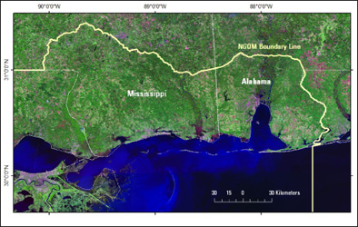
Study Area
High-Resolution Imagery Sources
Summary of Existing Data
High-Resolution LULC Data
Moderate-Resolution LULC Data
Ancillary Data
Priority Areas
Grand Bay Reserve
Gulf Islands National Seashore
City of Mobile
Summary
References Cited
Appendix A: Grand Bay National Estuarine Research Reserve 2002 Habitat Map Vegetation Class Descriptions

![]() U.S. Department of the Interior |
U.S. Geological Survey
U.S. Department of the Interior |
U.S. Geological Survey
URL: http://pubsdata.usgs.gov/pubs/of/2009/1028/index.html
Page Contact Information: USGS Publications Team
Page Last Modified: Wednesday, 07-Dec-2016 22:24:01 EST
