U.S. Geological Survey, 2009, PDF images of field description sheets from vibracores collected by the U.S. Geological Survey within Apalachicola Bay, Florida, 2007: Open-File Report 2009-1031, U.S. Geological Survey, Coastal and Marine Geology Program, Woods Hole Science Center, Woods Hole, MA.This is part of the following larger work.Online Links:
- <https://pubs.usgs.gov/of/2009/1031/data_catalog/>
- <https://pubs.usgs.gov/of/2009/1031/data_catalog/Core_Field_Descriptions/App-07_FieldLogs.zip>
Twichell, D., Pendleton, E., Poore, R., Osterman, L., and Kelso, K., 2009, Vibracore, Radiocarbon, Microfossil, and Grain-Size Data from Apalachicola Bay, Florida: Open-File Report 2009-1031, U.S. Geological Survey, Coastal and Marine Geology Program, Woods Hole Science Center, Woods Hole, MA.Online Links:
This is a Raster data set. It contains the following raster data types:
(508) 548-8700x2266 (voice)
(508) 457-2310 (FAX)
dtwichell@usgs.gov
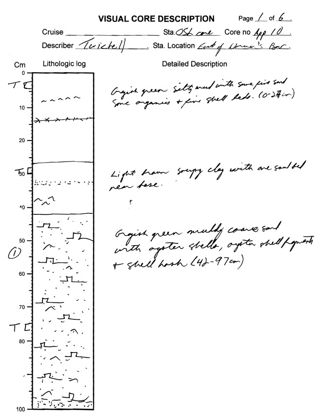
PDF images of each vibracore field description sheet for 24 vibracores collected by the U.S. Geological Survey during a 2007 cruise within Apalachicola Bay, Florida were generated in order to incorporate the raw core notes into electronic format. These field notes are the basis from which the core summaries are derived.
U.S. Geological Survey, Unpublished Material, vibracores collected by the U.S. Geological Survey within Apalachicola Bay, FL.
Person who carried out this activity:
(508) 548-8700x2266 (voice)
(508) 457-2310 (FAX)
dtwichell@usgs.gov
Person who carried out this activity:
(508) 548-8700x2266 (voice)
(508) 457-2310 (FAX)
dtwichell@usgs.gov
Twichell, D., Andrews, B., Edmiston, H., and Stevenson, W., 2007, Geophysical Mapping of Oyster Habitats in a Shallow Estuary; Apalachicola Bay, Florida: U.S. Geological Survey Open-File Report 2006-1381, U.S. Geological Survey, Woods Hole Science Center, Woods Hole, MA.Online Links:
There are no attributes associated with these PDF documents
The station location reported on the top of each core log sheet is for relative geographic purposes, and should not be used for precise core locations. The Differential Global Positioning System latitude and longitude for each core is recorded in the 'App07-CoreLocation' file included in this report, and these positions are assumed to be accurate within +/- 20 m.
All vibracores were collected from the R/V Gilbert using a Rossfelder vibracore. One vibracore was collected at each of the 23 predetermined locations, with the exception of site 18. Two cores were collected here because the first core (App07-18A) was recovered without a core catcher on the end, and several centimeters of the sample were lost. A second core was taken (App07-18B) at site 18, and both cores were processed and preserved. All 24 vibracore field descriptions were scanned to digital PDFs.
Core field descriptions were scanned and converted to PDF format in order to maintain a digital record of the data. All cores were described by the same interpreter, and standard core description techniques were used.
Are there legal restrictions on access or use of the data?
- Access_Constraints: None
- Use_Constraints:
- The Public domain data from the U.S. Government are freely redistributable with proper metadata and source attribution. Please recognize the U.S. Geological Survey as the originator of the dataset.
(508) 548-8700x2266 (voice)
(508) 457-2310 (FAX)
dtwichell@usgs.gov
Downloadable Data
Neither the U.S. Government, the Department of the Interior, nor the USGS, nor any of their employees, contractors, or subcontractors, make any warranty, express or implied, nor assume any legal liability or responsibility for the accuracy, completeness, or usefulness of any information, apparatus, product, or process disclosed, nor represent that its use would not infringe on privately owned rights. The act of distribution shall not constitute any such warranty, and no responsibility is assumed by the USGS in the use of these data or related materials. Any use of trade, product, or firm names is for descriptive purposes only and does not imply endorsement by the U.S. Government.
| Data format: | This WinZip file contains 24 PDF documents of vibracore field descriptions within Apalachicola Bay, Florida and the associated metadata. in format WinZip (version 9.0) Size: 1.036 Mbytes |
|---|---|
| Network links: |
<https://pubs.usgs.gov/of/2009/1031/data_catalog/Core_Field_Descriptions/App-07_FieldLogs.zip> |
| Media you can order: |
DVD-ROM
(Density 4.75
Gbytes)
(format UDF)
|
This zip file contains 24 data files available in Portable Document Format (.pdf). The user must have Adobe Reader or Adobe Acrobat Professional to view these files. Adobe Reader can be downloaded for free at get.adobe.com/reader
508-548-8700 x2259 (voice)
(508)-457-2310 (FAX)
ependleton@usgs.gov