U.S. Geological Survey Open-File Report 2009-1031
Vibracore, Radiocarbon, Microfossil, and Grain-Size Data from Apalachicola Bay, Florida
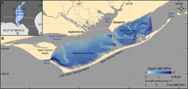
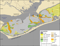
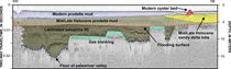
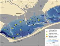
Apalachicola Bay is a large estuary in the northern Gulf of Mexico along the Florida panhandle (fig. 1). The bay is approximately 65 km long, 5.5 to 12 km wide, and has an average depth of 2 to 2.4 m (Twichell and others, 2007). This shallow bay is sheltered from the Gulf of Mexico by a string of barrier islands that are interrupted by four inlets, three natural and one artificial. Estuarine conditions are maintained in this bay by the Apalachicola River, the largest river in Florida (Leitman and others, 1983), the headwaters of which originate in western Georgia and eastern Alabama. A large delta at the mouth of this river is building into the northern part of the bay near the town of Apalachicola. The estuarine and substrate conditions of the bay are ideal for oyster growth, and consequently the bay is the largest oyster fishery in the state of Florida (Whitfield and Beaumariage, 1977). Sidescan-sonar imagery has been used to map in detail the distribution of oyster beds in the bay (Twichell and others, 2007). These data show that the present oyster beds are not uniformly distributed throughout the bay, but instead occur in clusters that are separated by a soft muddy sea floor, a substrate type that is not conducive to oyster growth (fig. 2). The mud is classified as distal fine-grained prodelta deposits associated with the Apalachicola River delta system that is advancing into the bay. High-resolution seismic profiles collected concurrently with the sidescan imagery have been used to infer the Holocene evolution of the bay (Twichell and others, 2007; Osterman and others, in press). A large paleovalley extends southwest under the bay and connects with a valley that extends across the shelf offshore of Government Cut (Donoghue, 1993; McKeown and others, 2004) (fig. 3). This valley was formed, or at least reoccupied, during the last lowstand of sea level. During the Holocene transgression, this valley was flooded and filled with deltaic and estuarine deposits. Between 4,000 and 6,000 yr before the present, sea level was within 3 to 5 m of its present elevation, the barrier islands started to form, and the bay took its present shape (Schnable and Goodell, 1968; Osterman and others, in press). The late Holocene evolution of the bay contributed to the present distribution of oyster beds in the estuary. The seismic profiles show that the oyster beds sit on shallow substrate that produce high-amplitude reflections and are absent from substrate that produced only low-amplitude reflections (fig. 4). These high-amplitude reflections appear as two lobe-shaped features that surround the oyster beds in the western and central parts of the bay, and the lobate shape suggests that the features are deltas that advanced southward into the bay. Twichell and others (2007) and Osterman and others (in press) inferred that the surfaces colonized by oysters were sandier than the surrounding bay floor, and that initially the oyster beds may have been more extensive but have since been buried by the continued input of prodelta muds. Missing from this earlier study were samples to verify the interpretation, which was based soley geophysical data. In 2007, the U.S. Geological Survey (USGS) undertook a coring program in Apalachicola Bay to test the inferences based on the seismic data. This report presents data from 24 vibracores collected during May, 2007 (fig. 5) aboard the R/V G.K. Gilbert. The report includes locations of the core sites and photographs, visual descriptions, and summary logs of the cores. Grain-size measurements, microfossil identification, and 14C ages were completed on selected intervals in several of the cores. Selected seismic profiles that were described in the report by Twichell and others (2007) are included as an aid to link the two datasets together. The research was funded by the USGS and was conducted to further our understanding of the geologic framework of the bay, to provide necessary information on the evolution of the bay for ongoing long-term monitoring and research, and to provide a basis for more informed coastal-management decisions for this estuary.
|

![]() U.S. Department of the Interior |
U.S. Geological Survey
U.S. Department of the Interior |
U.S. Geological Survey
URL: https://pubsdata.usgs.gov/pubs/of/2009/1031/html/intro.html
Page Contact Information: Contact USGS
Page Last Modified: Wednesday, 07-Dec-2016 22:15:12 EST