Open-File Report 2009-1086
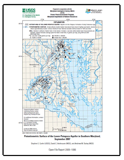
AbstractThis report presents a map showing the potentiometric surface of the lower Patapsco aquifer in the Patapsco Formation of Early Cretaceous age in Southern Maryland during September 2007. The map is based on water-level measurements in 65 wells. The highest measured water level was 111 feet above sea level near the northwestern boundary and outcrop area of the aquifer in northern Prince George’s County. From this area, the potentiometric surface declined towards well fields at Severndale and Arnold. The measured ground-water levels were 87 feet below sea level at Severndale, and 42 feet below sea level at Arnold. There was also a cone of depression covering a large area in Charles County that includes Waldorf, La Plata, Indian Head, and the Morgantown power plant. The ground-water levels measured were as low as 219 feet below sea level at Waldorf, 187 feet below sea level at La Plata, 106 feet below sea level at Indian Head, and 89 feet below sea level at the Morgantown power plant. |
For additional information contact: Part or all of this report is presented in Portable Document Format (PDF); the latest version of Adobe Reader or similar software is required to view it. Download the latest version of Adobe Reader, free of charge. |
Curtin, S.E., Andreasen, D.C., and Staley, A.W., 2009, Potentiometric surface of the Lower Patapsco aquifer in Southern Maryland, September 2007: U.S. Geological Survey Open-File Report 2009–1086, 1 map sheet.

![]() U.S. Department of the Interior |
U.S. Geological Survey
U.S. Department of the Interior |
U.S. Geological Survey
URL: https://pubsdata.usgs.gov/pubs/of/2009/1086/
Page Contact Information: Contact USGS
Page Last Modified: Wednesday, 07-Dec-2016 21:55:14 EST
