U.S. Geological Survey Open-File Report 2009-1137
Quaternary Geologic Framework of the St. Clair River between Michigan and Ontario, Canada
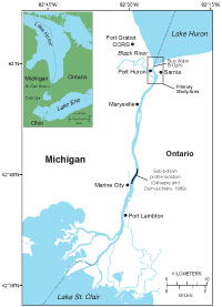
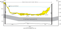
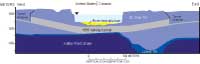
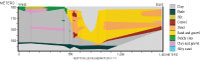
The St. Clair River is 44 km long and flows south from Lake Huron at the border between Michigan and Ontario, Canada, to Lake St. Clair. Concern about the effect of geomorphic changes in the St. Clair River on water levels in the Upper Great Lakes resulted in the need for current information on the surficial geologic framework of the river. The U.S. Geological Survey (USGS) Woods Hole Coastal and Marine Science Center (WHCMSC), in cooperation with the U.S. Army Corps of Engineers (USACE), completed a survey of the geologic framework of the St. Clair River from the riverhead, including the extreme lower reaches of Lake Huron, to the mouth of the Black River (fig. 1). Two additional areas farther south at Marysville, MI, and Port Lambton, Ontario (fig. 1) were surveyed, for comparison with the northernmost river geologic framework. This investigation was completed as a component of the International Upper Great Lakes Study (IUGLS) (International Upper Great Lakes Study, 2009) under the direction of the International Joint Commission (IJC). Purpose and ScopeThis report describes the surficial geology and stratigraphy of the northernmost St. Clair River and assesses the relation between geologic framework and morphologic changes in the St. Clair River channel. The results of this mapping will be used to determine whether the substrate has been eroded, which could result in changes in river-channel morphology and geometry. Ultimately, the IUGLS will attempt to determine whether physical changes in the St. Clair River affect water flow and, subsequently, water levels in the Upper Great Lakes. Geologic SettingMany studies and reviews have discussed the geologic evolution of the Great Lakes (Larson and Schaetzl, 2001), and Morris (2008) examined the pertinent Quaternary geology in the St. Clair River region. These studies indicate that on the eastern side of the Michigan Basin, upper Devonian Antrim Shale (Kettle Point Formation in Ontario) or Mississippian Bedford Shale underlies the St. Clair River (Hough, 1958; Randall, 1987). Glacial drift was deposited in the St. Clair River area during the advance and retreat of the Huron Lobe of the Laurentide Ice Sheet. Beginning 23,000 yr before present (b.p.), the ice sheet advanced and retreated several times, depositing till and glaciolacustrine and glaciofluvial sediment. Intermittently, throughout glacial and postglacial history, the St. Clair River channel has been a primary outlet for drainage of the Lake Huron basin. Larsen (1994) summarized the Holocene history of the Port Huron outlet. The channel has been used continuously as an outlet since the Nipissing I highstand phase of the Great Lakes between 5,000 and 4,000 yr b.p. Water levels in Lake Huron progressively declined as the St. Clair River incised glacial material between 5,000 and 2,100 yr b.p. The outlet and river elevation stabilized after 2,100 yr b.p. The modern St. Clair River extends 44 km from Lake Huron before the channel splits into multiple channels where an extensive delta has formed in Lake St. Clair. Lake St. Clair drains into Lake Erie through the Detroit River. The St. Clair River is the outlet for Lake Huron and is the primary mechanism that naturally regulates water levels of Lake Huron and Lake Michigan. Over the length of the St. Clair River, the water elevation falls approximately 1.5 m. The flow is greatest in the northernmost section of the river where the channel is constricted near the Blue Water Bridges (fig. 1). Depending on variations in discharge, average velocity (for the cross section of the river) at this location varies from 1.1 to 2.0 m/s (National Oceanic and Atmospheric Administration, 2009). Sand and gravel mining along with dredging of navigation channels modified the natural regime of the St. Clair River channel beginning in the mid 1800’s, and sections of the riverbanks have been infilled and armored (Derecki, 1985; U.S. Army Corps of Engineers, 2009). Previous WorkSingle-beam and multibeam bathymetric data are available from the National Oceanic and Atmospheric Administration (NOAA) and the USACE. Surveys that cover the entire river were conducted in 1971 and 2000 (both single-beam) and in 2007 (multibeam). In 2002, 2005, and 2006, multibeam surveys of the northernmost 4 km of the river were completed. Bennion (2009) documented the availability of and limitations associated with these data and completed an extensive spatial and statistical analysis of them that spans a 36-year period. His results indicated areas of active change in riverbed elevation. The most recent multibeam bathymetric data were collected in 2008 for the upper 7 km of the St. Clair River (Best and others, 2009). Sidescan-sonar data have been collected in the northermost St. Clair River (G.W. Kennedy, U.S. Geological Survey, written commun., 2009) for use in fish-habitat studies. Substrate types of silt, sand, gravel, cobbles, and hardpan (clay) and rubble were interpreted and mapped on the basis of variations in acoustic backscatter. Manny and Kennedy (2002) examined the St. Clair River bed in the Port Huron area using underwater video. They observed cobble and gravel beds that were free of interstitial sand and silt. Video observations in the northermost St. Clair River from 2005, 2007, and 2008 show wide areas of the riverbed armored by coarse gravel, pebbles, and cobbles (Krishnappan, 2009). Gillespie and Dumouchelle (1989) presented an interpretation of a seismic profile near Marine City, MI, about 30 km south of the head of the St. Clair River. The profile shows undifferentiated till and glaciolacustrine deposits over Bedford and Antrim Shale. Their interpretation is based on correlation with nearby well logs. Although Gillespie and Dumouchelle (1989) did not collect seismic profiles within our primary study area, they presented four geologic sections compiled from descriptions of wells in the Port Huron, MI, area. These profiles show mostly undifferentiated silty-clay till and glaciolacustrine deposits over shale in the vicinity of the St. Clair River. McGee (1990) collected seismic profiles in the St. Clair River. He did not interpret the ages of the stratigraphic units but correlated the units to lithologic data from boreholes. One of the seismic profiles is in the vicinity of the railway tunnels just south of the current study area. The profile shows the top of bedrock and a reflection off the top of the original railway tunnel (these data were collected before a second railway tunnel was constructed in 1995) within the sediment overlying bedrock. An intermediate reflection is noted within the overburden. McGee’s (1990) interpretation, based on descriptions from borings collected in 1885 and 1888 (Gilbert, 1991), indicates that the overburden is firm clay containing large boulders and lenses of sand and gravel. Diffractions within the profile are a result of these inhomogeneities within the firm clay. The intermediate reflection is referred to as the top of a sand layer in which the lower part of the tunnel was constructed. Morris (2008) provided a detailed interpretation based on the cross sections (fig. 2) from the old railway tunnel (Gilbert, 1991) and the new (completed in 1995) tunnel constructed adjacent to the old tunnel (Finch, 1996). Unlike the old tunnel cross section, the new cross section (fig. 3) shows a lower till unit over bedrock that is composed of overconsolidated sand and silt. Based on stratigraphic position and physical description, this lower till unit may be the Catfish Creek Till, a thin (1-3 m), moderately stony to very stony, very compact, sandy silt to silt till deposited over bedrock during the Nissouri Stadial (23,000-18,000 yr b.p.). The “Blue Clay” referred to in the old tunnel section and the “St. Clair Till” described in the new tunnel location by Finch (1996) are undifferentiated fine-grained tills and glaciolacustrine deposits; these tills could include the Tavistock and Rannoch Tills, deposited during the Port Bruce Stadial (15,000-14,000 yr b.p.), and the St. Joseph Till deposited during the Port Huron Stadial (13,300-13,000 yr b.p.). Morris (2008) suggested that there are interbedded fine-grained glaciolacustrine materials likely to be associated with interstadial events. Overlying the tills is a unit generally referred to as fine sand, sand, gravel and sand, and small boulders or as riverbed alluvium (Finch, 1996). The fine sand is found primarily along the flanks of the channel with the coarser material in the middle. The coarse-grained material in the northernmost section of the river was likely deposited as proglacial subaquatic fans during the latter stages of the Port Huron Stadial, when the Huron Lobe just north of where the Wyoming Moraine (Port Huron Moraine of Michigan) would cross the St. Clair River channel about 12 km south of the head of the St. Clair River. The source of the fine sand along the banks of the channel is likely reworked from beaches associated with a lower lake level in Lake Algonquin or from sand transported by longshore drift from the Lake Huron nearshore into the head of the St. Clair River. A series of boreholes related to the foundation investigations conducted prior to the construction of the second Blue Water Bridge provide a cross-river borehole transect (fig. 4). For this geologic section, Morris (2008) interpreted the same stratigraphy of undifferentiated till and glaciolacustrine units at this location as in the railway tunnel area to the south, except that here relatively thick sand and gravel deposits underlie the modern river channel and extend east of the channel. The sand and gravel overlies and appears to cut into a clay unit, which overlies shale. The sand and gravel are interpreted as proglacial subaquatic fan deposits. |

![]() U.S. Department of the Interior |
U.S. Geological Survey
U.S. Department of the Interior |
U.S. Geological Survey
URL: https://pubsdata.usgs.gov/pubs/of/2009/1137/html/introduction.html
Page Contact Information: Contact USGS
Page Last Modified: Wednesday, 07-Dec-2016 21:58:33 EST