U.S. Geological Survey Open-File Report 2009-1137
|
By David S. Foster and Jane F. Denny 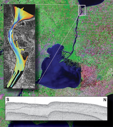
|
U.S. Department of the Interior
KEN SALAZAR, Secretary
U.S. Geological Survey
Suzette M. Kimball, Acting Director
U.S. Geological Survey, Reston, Virginia: 2009
For more information on the USGS—the Federal source for science about the Earth, its natural and living resources, natural hazards, and the environment:
World Wide Web: http://www.usgs.gov
Telephone: 1-888-ASK-USGS
Suggested citation:
Foster, David S., and Denny, Jane F., 2009, Quaternary geologic framework of the St. Clair River between Michigan and Ontario, Canada: U.S. Geological Survey Open-File Report 2009-1137, available online at https://pubs.usgs.gov/of/2009/1137/.
Any use of trade, product, or firm names is for descriptive purposes only and does not imply endorsement by the U.S. Government. This report has not been reviewed for conformity with U.S. Geological Survey stratigraphic nomenclature.
Although this report is in the public domain, permission must be secured from the individual copyright owners to reproduce any copyrighted material contained within this report.

![]() U.S. Department of the Interior |
U.S. Geological Survey
U.S. Department of the Interior |
U.S. Geological Survey
URL: https://pubsdata.usgs.gov/pubs/of/2009/1137/title_page.html
Page Contact Information: Contact USGS
Page Last Modified: Wednesday, 07-Dec-2016 21:58:10 EST
