U.S. Geological Survey, 2010, NLONDON_OUTLINE: Outline of the Combined Multibeam and LIDAR Bathymetry Data Collected During National Oceanic and Atmospheric Administration (NOAA) Surveys H11441 and H11224 (Geographic, WGS84): Open-File Report 2009-1231, U.S. Geological Survey, Coastal and Marine Geology Program, USGS Woods Hole Coastal and Marine Science Center, Woods Hole, MA.This is part of the following larger work.Online Links:
- <https://pubs.usgs.gov/of/2009/1231/data/basemaps/outlines/nlondon/nlondon_outline.zip>
- <https://pubs.usgs.gov/of/2009/1231/data/basemaps/outlines/nlondon/>
- <https://pubs.usgs.gov/of/2009/1231/html/catalog.html>
Poppe, L.J., Danforth, W.W., McMullen, K.Y., Parker, C.E., Lewit, P.G., and Doran, E.F., 2010, Integrated Multibeam and LIDAR Bathymetry Data Offshore of New London and Niantic, Connecticut: Open-File Report 2009-1231, U.S. Geological Survey, Coastal and Marine Geology Program, USGS Woods Hole Coastal and Marine Science Center, Woods Hole, MA.Online Links:
This is a Vector data set. It contains the following vector data types (SDTS terminology):
Horizontal positions are specified in geographic coordinates, that is, latitude and longitude. Latitudes are given to the nearest 0.000001. Longitudes are given to the nearest 0.000001. Latitude and longitude values are specified in Decimal degrees.
The horizontal datum used is D_WGS_1984.
The ellipsoid used is WGS_84.
The semi-major axis of the ellipsoid used is 6378137.000000.
The flattening of the ellipsoid used is 1/298.257224.
Whole numbers that are automatically generated.
Coordinates defining the features.
Whole numbers that are automatically generated
508-548-8700 x2314 (voice)
508-457-2310 (FAX)
lpoppe@usgs.gov
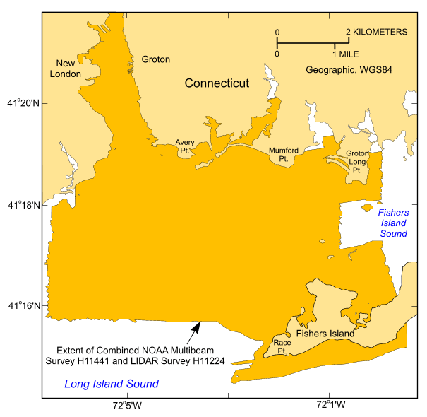
To release an outline of the combined multibeam and LIDAR bathymetry data generated during NOAA surveys H11441 and H11224 in the vicinity of New London, offshore Connecticut, in geographic, WGS84.
Christman, Emily B. , 2005, H11441: Descriptive Report H11441, National Ocean Survey, National Oceanic and Atmospheric Administration, Atlantic Hydrographic Branch, Norfolk, VA.Online Links:
Stephenson, Darren, 2004, H11224: Descriptive Report H11224, National Ocean Survey, National Oceanic and Atmospheric Administration, Atlantic Hydrographic Branch, Norfolk, VA.Online Links:
Person who carried out this activity:
508-548-8700 x2314 (voice)
508-457-2310 (FAX)
lpoppe@usgs.gov
Data sources produced in this process:
Person who carried out this activity:
508-548-8700 x2314 (voice)
508-457-2310 (FAX)
lpoppe@usgs.gov
Data sources produced in this process:
Christman, Emily B. , 2005, H11441: Descriptive report H11441, National Ocean Survey, National Oceanic and Atmospheric Administration, Atlantic Hydrographic Branch, Norfolk, VA.Online Links:
Stephenson, Darren, 2004, H11224: Descriptive Report H11224, National Ocean Survey, National Oceanic and Atmospheric Administration, Atlantic Hydrographic Branch, Norfolk, VA.Online Links:
Poppe, L.J., Ackerman, S.D., Doran, E.F., Beaver, A.J., Crocker, J.M., and Schattgen, P.T., 2006, Interpolation of reconnaissance multibeam bathymetry from north-central Long Island Sound: Open-File Report 2005-1145, U.S. Geological Survey, Coastal and Marine Geology Program, Woods Hole Coastal and Marine Science Center, Woods Hole, MA.Online Links:
Position of the launches acquiring multibeam bathymetry were monitored by an Applanix TSS POS/MV 320 Version 3 GPS aided navigation system. Real-time positioning during LIDAR acquisition was obtained by an Ashtech GG24 GPS receiver combined with Thales GeoSolutions Wide Area DGPS. Ashtech Z12 GPS receivers, provided as part of the Airborne System and Ground Systems, also logged GPS data on the aircraft and at a locally established base station to provide post processed KGPS position solutions.
This data layer shows the extent and locations of the areas surveyed during NOAA surveys H11441 and H11224.
No additional checks for consistency were performed on this data.
Are there legal restrictions on access or use of the data?
- Access_Constraints: None
- Use_Constraints:
- Public domain data are freely redistributable with proper metadata and source attribution. Please recognize the U.S. Geological Survey (USGS) as the originator of this information.
508-548-8700 x2314 (voice)
508-457-2310 (FAX)
lpoppe@usgs.gov
Downloadable Data
Neither the U.S. Government, the Department of the Interior, nor the USGS, nor the National Oceanic and Atmospheric Administration (NOAA), nor the Connecticut Department of Environmental Protection (CT DEP) nor any of their employees, contractors, or subcontractors, make any warranty, express or implied, nor assume any legal liability or responsibility for the accuracy, completeness, or usefulness of any information, apparatus, product, or process disclosed, nor represent that its use would not infringe on privately owned rights. The act of distribution shall not constitute any such warranty, and no responsibility is assumed by the USGS, NOAA, or the CT DEP in the use of these data or related materials. Any use of trade, product, or firm names is for descriptive purposes only and does not imply endorsement by the U.S. Government.
| Data format: | The shapefile (nlondon_outline.shp, nlondon_outline.shx, nlondon_outline.dbf, nlondon_outline.prj) , browse graphic, and metadata. in format SHP (version 3.3) ESRI polygon shapefile Size: 0.12 |
|---|---|
| Network links: |
<https://pubs.usgs.gov/of/2009/1231/data/basemaps/outlines/nlondon/nlondon_outline.zip> <https://pubs.usgs.gov/of/2009/1231/data/basemaps/outlines/nlondon/> <https://pubs.usgs.gov/of/2009/1231/html/catalog.html> |
| Media you can order: | CD-ROM (Density 640 Mbytes) (format ISO9660) |
These data are available in Environmental Systems Research Institute (ESRI) shapefile format. The user must have ArcGIS or ArcView 3.0 or greater software to read and process the data file. In lieu of ArcView or ArcGIS, the user may utilize another GIS application package capable of importing data. A free data viewer, ArcExplorer, capable of displaying the data is available from ESRI at www.esri.com. The user must have software capable of uncompressing archived zip files, such as WinZip or Pkware.
508-548-8700 x2314 (voice)
508-457-2310 (FAX)
lpoppe@usgs.gov