 |
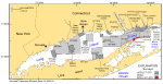
Figure 1. Index map of Long Island Sound study area, U.S. Geological Survey (USGS)/Connecticut Department of Environmental Protection (CT DEP) surveys, and National Oceanic and Atmospheric Administration (NOAA) hydrographic surveys. NOAA hydrographic surveys include: H11250--Poppe and others (2006c, 2007b); H11255--Poppe and others (2006b); H11252/H11361--Poppe and others (2007a, 2008); H11043--Poppe and others (2004); H11044--McMullen and others (2005), Poppe and others (2006a); H11045--Beaulieu and others (2005). USGS/CT DEP sidescan-sonar surveys include: Norwalk--Twichell and others (1997); Milford--Twichell and others (1998); New Haven Harbor and Central Long Island Sound (CLIS) dumping grounds--Poppe and others (2001); Roanoke Point--Poppe and others (1999b); Falkner Island--Poppe and others (1999a); Hammonasset--Poppe and others (1997); Niantic Bay--Poppe and others (1998b); New London--Lewis and others (1998), Zajac and others (2000, 2003); Fishers Island Sound--Poppe and others (1998a). |
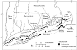 |
Figure 2. Location map of end moraines (black polygons) and submerged ridges (dashed lines) in southern New York and New England (modified from Gustavson and Boothroyd, 1987). The Ronkonkoma-Block Island-Nantucket end moraine represents the maximum advance of the Laurentide Ice Sheet about 20,000 years ago, and the Harbor Hill-Roanoke Point-Charlestown-Buzzards Bay end moraine represents a retreated ice-sheet position from about 18,000 years ago (Uchupi and others, 2001). |
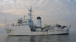 |
Figure 3. The National Oceanic and Atmospheric Administration Ship Thomas Jefferson. |
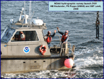 |
Figure 4. National Oceanic and Atmospheric Administration launch 3101 in Long Island Sound. |
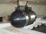 |
Figure 5. RESON SeaBat 8101 used to collect bathymetric data on National Oceanic and Atmospheric Administration launch 3102 during survey H11445. |
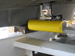 |
Figure 6. RESON SeaBat 8125 used to collect bathymetric data on National Oceanic and Atmospheric Administration launch 3101 during survey H11445. |
 |
Figure 7. Klein 5000, hull-mounted to National Oceanic and Atmospheric Administration launch 3102, collected sidescan-sonar data during survey H11445. |
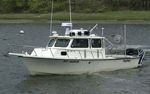 |
Figure 8. The U.S. Geological Survey R/V Rafael was used to collect bottom photography and sediment samples in the study area. |
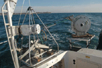 |
Figure 9. The small Seabed Observation and Sampling System (SEABOSS), a modified Van Veen grab equipped with still and video photographic systems, mounted on the aft starboard side of the R/V Rafael. Note the winch mounted on the davit (left) and the take-up reel for the video-signal and power cable (right). |
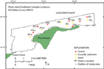 |
Figure 10. Location of stations in the study area where photography and sediment samples were collected during R/V Rafael cruise 09059. |
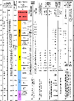 |
Figure 11. Chart showing the relationships between phi sizes, millimeter diameters, size classifications (Wentworth, 1922), and American Society for Testing and Materials and Tyler sieve sizes. Chart also shows the corresponding intermediate diameters, grains per milligram, settling velocities, and threshold velocities for traction. |
 |
Figure 12. Sediment-classification scheme from Shepard (1954), as modified by Schlee (1973). |
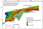 |
Figure 13. Hill-shaded multibeam bathymetry obtained during National Oceanic and Atmospheric Administration survey H11445. Warmer colors are shallower areas and cooler colors are deeper areas. Boxes show locations of figures 14, 16, 18, and 20. |
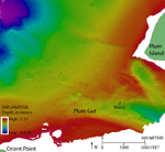 |
Figure 14. Detailed multibeam bathymetry near Plum Gut, the channel between Orient Point and Plum Island. The sea floor in the channel is hummocky, while the surrounding sea floor is relatively smooth. A tractor-trailer wreck is located in Plum Gut. Location of image shown in figure 13. |
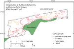 |
Figure 15. Interpretation of multibeam bathymetry and sidescan sonar from National Oceanic and Atmospheric Administration survey H11445. Delineated areas include boulders (red) and sand waves (orange). A wreck, a tractor trailer, is located southwest of Plum Island. |
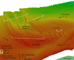 |
Figure 16. Detailed multibeam bathymetry of sand waves on the shoal north of Plum Island. The shoal is maintained by counterclockwise net sediment transport, as indicated by sand wave asymmetries and a scour mark. Boulders are present near the shore. Sand-wave profiles are shown in figure 17. Location of image shown in figure 13. |
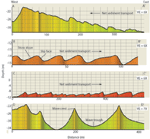 |
Figure 17. Sand-wave profiles of waves on shoal north of Plum Island. Arrows show direction of net sediment transport. Profile A-A' shows waves with asymmetries suggesting a westward net sediment transport. Profiles B-B' and C-C' show waves with asymmetries suggesting an eastward net sediment transport. Profile D-D' shows waves that are symmetrical and are probably not moving. Vertical exaggeration is 6X in profiles A-A', B-B', and C-C' and 7X in profile D-D'. Locations of profiles shown in figure 16. |
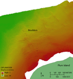 |
Figure 18. Detailed multibeam bathymetry image of boulders north of Plum Island, which are part of the Harbor Hill-Roanoke Point-Charlestown-Buzzards Bay moraine. Location of image shown in figure 13. |
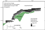 |
Figure 19. Sidescan-sonar imagery from National Oceanic and Atmospheric Administration survey H11445. Lighter tones represent high backscatter and are interpreted as coarser grained material capable of reflecting more of the sonar waves. Darker tones represent low backscatter and are interpreted as finer grained materials, such as sand. |
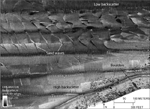 |
Figure 20. Detailed sidescan-sonar image of sand waves and boulders in the study area. Also shown are high backscatter (lighter tones and coarser grained sediment) and low backscatter (darker tones and finer grained sediment). Location of image shown in figure 13. |
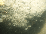 |
Figure 21. Photograph of the sea floor at station PI12 showing a boulder encrusted with sponges, anemones, and hydrozoans. Boulders and gravel on the sea floor are indicated by high backscatter in sidescan-sonar imagery. |
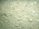 |
Figure 22. Photograph of the sea floor at station PI10 showing a gravelly environment. Gravel on the sea floor is indicated by high backscatter in sidescan-sonar imagery. |
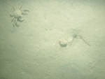 |
Figure 23. Photograph of the sea floor at station PI7 showing a sandy environment and a spider crab. Low backscatter in sidescan-sonar imagery from the study area indicates a sandy sea floor. |
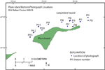 |
Figure 24. Location of bottom photographs taken on R/V Rafael cruise 09059 offshore of Plum Island, New York. |


