U.S. Geological Survey Open-File Report 2010–1005
Surficial Geology of the Sea Floor in Long Island Sound Offshore of Plum Island, New York
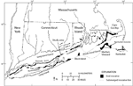
During the Late Wisconsinan, the Laurentide glacier covered all of New England and New York including Long Island. Today Long Island Sound contains deposits recording the history of glacial retreat, formation of glacial lakes, and a marine transgression. The Connecticut Valley Lobe of the glacier covered the study area, reaching its furthest extent around 20,000–22,000 years ago at a position marked by the Ronkonkoma-Block Island-Nantucket moraine system (fig. 2; Sirkin, 1980; Stone and Borns, 1986; Uchupi and others, 2001). The glacier retreated northward around 18,000 years ago to a position marked by the Harbor Hill-Roanoke Point-Charlestown-Buzzards Bay moraine line (Uchupi and others, 2001). Orient Point and Plum Island are covered with end-moraine deposits, and the adjacent sea floor forms the submerged part of this morainal ridge (Stone and Borns, 1986). Proglacial lakes formed behind the end moraines as the glacier melted and retreated northward. Glacial Lake Connecticut existed in present-day Long Island Sound from about 17,500 to 15,500 years ago (Uchupi and others, 2001). Plum Gut, the channel between Plum Island and Orient Point, is located where a fluvial channel and rising sea level cut through the Roanoke Point-Orient Point-Fishers Island moraine system (Sirkin, 1980). As sea level rose, lower parts of the moraine were submerged and higher elevations were isolated as islands, such as Plum Island. Presently, tidal currents up to 3.2 knots flow through Plum Gut (White and White, 2008) and likely help to maintain the bathymetric depressions in this channel. |

![]() U.S. Department of the Interior |
U.S. Geological Survey
U.S. Department of the Interior |
U.S. Geological Survey
URL: https://pubsdata.usgs.gov/pubs/of/2010/1005/html/setting.html
Page Contact Information: Contact USGS
Page Last Modified: Wednesday, 07-Dec-2016 22:35:46 EST