U.S. Geological Survey Open-File Report 2010–1100
Surficial Geology of the Sea Floor in Long Island Sound Offshore of Orient Point, New York
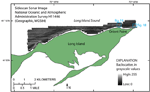
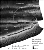
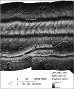
Sidescan-sonar data were collected in the shoreward 6.12 km² of the study area (fig. 17). Higher backscatter areas (lighter tones, generally representing coarser grained sediment) are located mostly near the shore and lower backscatter areas (darker tones, generally representing finer grained sediment) are more commonly located farther from the shore and in deeper areas. Patterns present in the sidescan-sonar data include high-backscatter targets with low-backscatter shadows and tiger-striped areas. Boundaries between areas are commonly gradational and may overlap. Dark stripes in the middle of sonar lines are nadir gaps and do not indicate textural or topographic changes in the sea floor. High-backscatter targets are boulders that are part of the Harbor Hill-Roanoke Point-Orient Point-Charlestown-Buzzards Bay end moraine system. Scour marks are present in the sediment near some of the boulders in the study area, as discussed in the Bathymetry section of this report. They are also visible in the sidescan-sonar imagery as lighter toned areas surrounding the boulders and extending several meters to more than 20 m on the down-current side (fig. 18). The lighter areas suggest that coarser grained sediment was left from current erosion. Tiger-striped areas are sand-wave fields, which are scattered throughout the survey area (fig. 19). This pattern results from a combination of topographic changes affecting the angle of incidence of the sidescan sonar and the differences in sediment texture commonly present between crests and troughs of sand waves. Additional details of the sand waves are discussed in the Bathymetry section of this report. |