Skip past header information
USGS - science for a changing world
NOAA Logo with link to NOAA Home Page.CT DEP Logo with link to CT DEP Home Page.  

U.S. Geological Survey Open-File Report 2010–1150

Sea-Floor Geology and Topography Offshore in Eastern Long Island Sound


Skip past contents information

Title | List of Figures | Conversion Factors | Abstract | Introduction | Methods | Bathymetry | Sediment Distribution | Bottom Photography | GIS Data Catalog | Summary | Acknowledgments | References | Contacts


Figure 14. A bathymetric image of boulders in the study area.

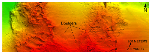
Figure 14. Detailed planar view of the rough bouldery sea floor north of Plum Island from the digital terrain model produced from bathymetric data collected during National Oceanic and Atmospheric Administration survey H11997. Boulders rest on the surface of the submerged Harbor Hill-Roanoke Point-Fishers Island end moraine. Location of view is shown in figure 12.

Skip USGS links group

Accessibility FOIA Privacy Policies and Notices

Take Pride in America logo USAGov logo U.S. Department of the Interior | U.S. Geological Survey
End of USGS links group