Skip past header information
USGS - science for a changing world
NOAA Logo with link to NOAA Home Page.CT DEP Logo with link to CT DEP Home Page.  

U.S. Geological Survey Open-File Report 2010–1150

Sea-Floor Geology and Topography Offshore in Eastern Long Island Sound


Skip past contents information

Title | List of Figures | Conversion Factors | Abstract | Introduction | Methods | Bathymetry | Sediment Distribution | Bottom Photography | GIS Data Catalog | Summary | Acknowledgments | References | Contacts


Figure 19. A diagram of sand-wave cross sections.

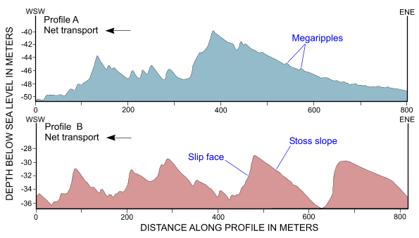
Figure 19. Cross-sectional views of transverse sand waves from the eastern part of the digital terrain model produced from bathymetric data collected during National Oceanic and Atmospheric Administration survey H11997. Sand-wave asymmetry indicates a westward net sediment transport; the presence of megaripples on stoss slopes suggests transport is active. Locations of profiles are shown in figure 12.

Skip USGS links group

Accessibility FOIA Privacy Policies and Notices

Take Pride in America logo USAGov logo U.S. Department of the Interior | U.S. Geological Survey
End of USGS links group