U.S. Geological Survey Open-File Report 2010-1170
Summary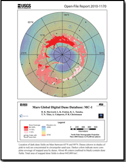
The Mars Global Digital Dune Database presents data and describes the methodology used in creating the global database of moderate- to large-size dune fields on Mars. The database is being released in a series of U.S. Geological Survey (USGS) Open-File Reports. The first release (Hayward and others, 2007) included dune fields from 65° N to 65° S (https://pubs.usgs.gov/of/2007/1158/). The current release encompasses ~ 845,000 km2 of mapped dune fields from 65° N to 90° N latitude. Dune fields between 65° S and 90° S will be released in a future USGS Open-File Report. Although we have attempted to include all dune fields, some have likely been excluded for two reasons: (1) incomplete THEMIS IR (daytime) coverage may have caused us to exclude some moderate- to large-size dune fields or (2) resolution of THEMIS IR coverage (100m/pixel) certainly caused us to exclude smaller dune fields. The smallest dune fields in the database are ~ 1 km2 in area. While the moderate to large dune fields are likely to constitute the largest compilation of sediment on the planet, smaller stores of sediment of dunes are likely to be found elsewhere via higher resolution data. Thus, it should be noted that our database excludes all small dune fields and some moderate to large dune fields as well. Therefore, the absence of mapped dune fields does not mean that such dune fields do not exist and is not intended to imply a lack of saltating sand in other areas. Where availability and quality of THEMIS visible (VIS), Mars Orbiter Camera narrow angle (MOC NA), or Mars Reconnaissance Orbiter (MRO) Context Camera (CTX) images allowed, we classified dunes and included some dune slipface measurements, which were derived from gross dune morphology and represent the prevailing wind direction at the last time of significant dune modification. It was beyond the scope of this report to look at the detail needed to discern subtle dune modification. It was also beyond the scope of this report to measure all slipfaces. We attempted to include enough slipface measurements to represent the general circulation (as implied by gross dune morphology) and to give a sense of the complex nature of aeolian activity on Mars. The absence of slipface measurements in a given direction should not be taken as evidence that winds in that direction did not occur. When a dune field was located within a crater, the azimuth from crater centroid to dune field centroid was calculated, as another possible indicator of wind direction. Output from a general circulation model (GCM) is also included. In addition to polygons locating dune fields, the database includes THEMIS visible (VIS) and Mars Orbiter Camera Narrow Angle (MOC NA) images that were used to build the database. The database is presented in a variety of formats. It is presented as an ArcReader project which can be opened using the free ArcReader software. The latest version of ArcReader can be downloaded at http://www.esri.com/software/arcgis/arcreader/download.html. The database is also presented in an ArcMap project. The ArcMap project allows fuller use of the data, but requires ESRI ArcMap® software. A fuller description of the projects can be found in the NP_Dunes_ReadMe file (NP_Dunes_ReadMe folder_ and the NP_Dunes_ReadMe_GIS file (NP_Documentation folder). For users who prefer to create their own projects, the data are available in ESRI shapefile and geodatabase formats, as well as the open Geography Markup Language (GML) format. A printable map of the dunes and craters in the database is available as a Portable Document Format (PDF) document. The map is also included as a JPEG file. (NP_Documentation folder) Documentation files are available in PDF and ASCII (.txt) files. Tables are available in both Excel and ASCII (.txt) |
For additional information: Part of this report is presented in Portable Document Format (PDF); the latest version of Adobe Reader or similar software is required to view it. Download the latest version of Adobe Reader, free of charge. |
Hayward, R.K., Fenton, L.K., Tanaka, K.L., Titus, T.N., Colaprete, A., and Christensen, P.R., 2010, Mars Global Digital Dune Database; MC-1: U.S. Geological Survey Open-File Report 2010-1170.

![]() U.S. Department of the Interior |
U.S. Geological Survey
U.S. Department of the Interior |
U.S. Geological Survey
URL: http://
pubsdata.usgs.gov
/pubs/of/2010/1170/index.html
Page Contact Information: USGS Publications Team
Page Last Modified: Wednesday, 07-Dec-2016 22:39:58 EST
