Open-File Report 2010-1330
1U.S. Geological Survey, St. Petersburg Science Center, St. Petersburg, FL 33701,
2Jacobs Technology, contracted to U.S. Geological Survey, St. Petersburg, FL 33701
Contents
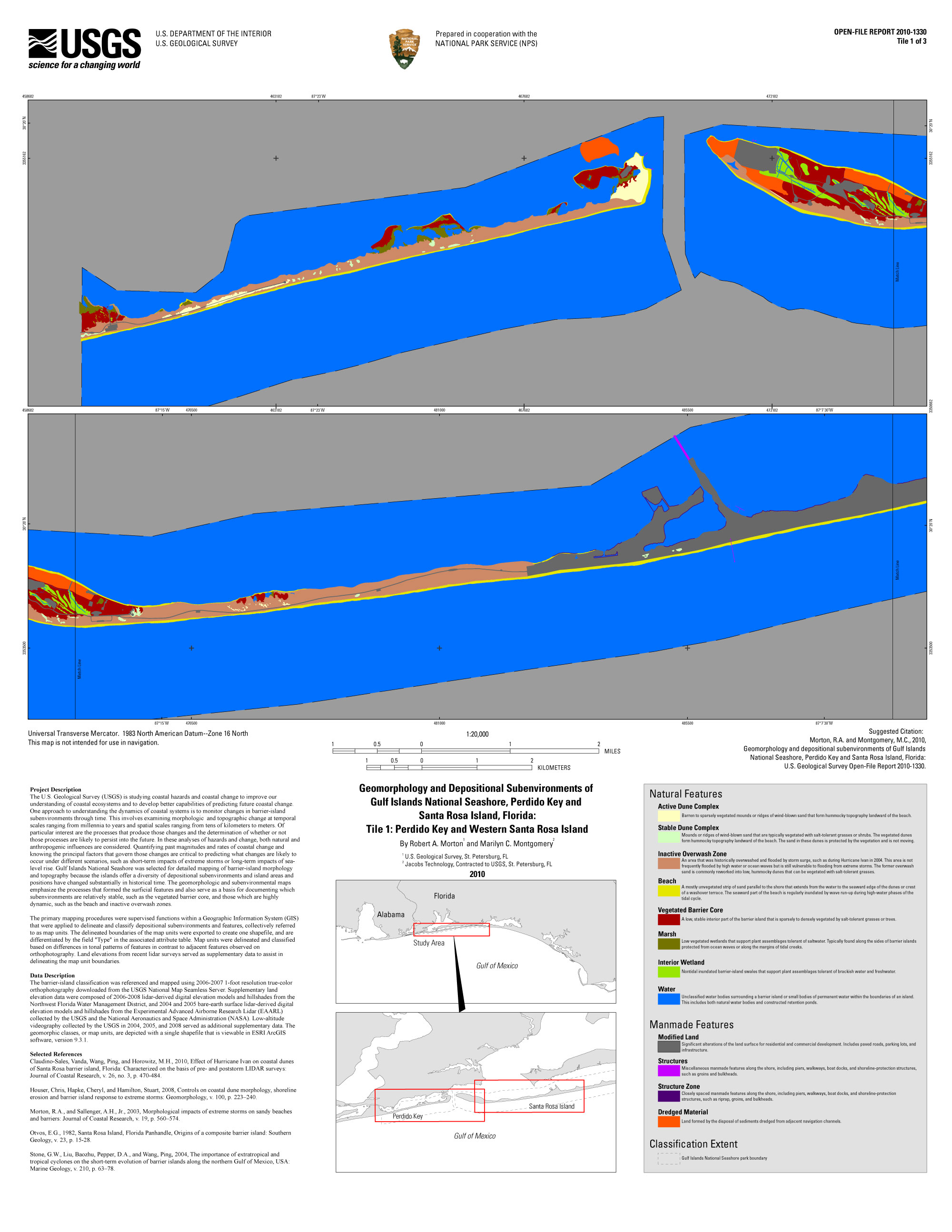
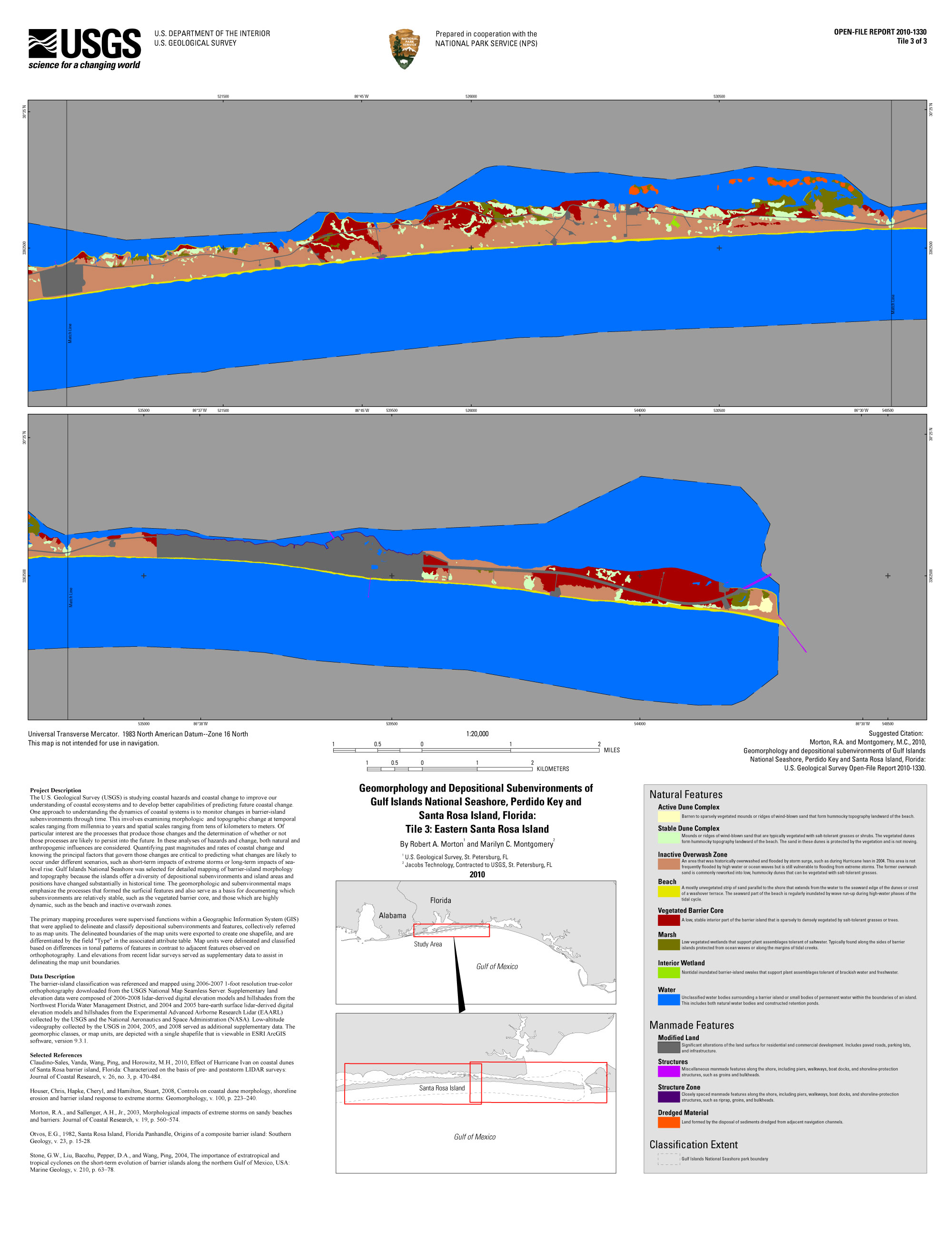
The U.S. Geological Survey (USGS) is studying coastal hazards and coastal change to improve our understanding of coastal ecosystems and to develop better capabilities of predicting future coastal change. One approach to understanding the dynamics of coastal systems is to monitor changes in barrier-island subenvironments through time. This involves examining morphologic and topographic change at temporal scales ranging from millennia to years and spatial scales ranging from tens of kilometers to meters. Of particular interest are the processes that produce those changes and the determination of whether or not those processes are likely to persist into the future. In these analyses of hazards and change, both natural and anthropogenic influences are considered. Quantifying past magnitudes and rates of coastal change and knowing the principal factors that govern those changes are critical to predicting what changes are likely to occur under different scenarios, such as short-term impacts of extreme storms or long-term impacts of sea-level rise. Gulf Islands National Seashore was selected for detailed mapping of barrier-island morphology and topography because the islands offer a diversity of depositional subenvironments and because island areas and positions have changed substantially in historical time. The geomorphologic and subenvironmental maps emphasize the processes that formed the surficial features and also serve as a basis for documenting which subenvironments are relatively stable, such as the vegetated barrier core, and those which are highly dynamic, such as the beach and inactive overwash zones.
The primary mapping procedures were supervised functions within a Geographic Information System (GIS) that were applied to delineate and classify depositional subenvironments and features, collectively referred to as map units. The delineated boundaries of the map units were exported to create one shapefile, and are differentiated by the field "Type" in the associated attribute table. Map units were delineated and classified based on differences in tonal patterns of features in contrast to adjacent features observed on orthophotography. Land elevations from recent lidar surveys served as supplementary data to assist in delineating the map unit boundaries.
The geomorphology and depositional subenvironments of Gulf Islands National Seashore
Click on the links below to download large format (34x44), print resolution map tiles or to view the map tiles on your display. You will need to have the free Adobe Acrobat® Reader installed on your computer to print the PDF map tiles.
Download print versions of the maps. (Right click on the link and select Save As... File sizes may vary)
View maps on screen.

This dataset includes one shapefile depicting each map unit classification relevant to the study area. The map unit types are differentiated by the field "Type" in the associated attribute table.
The barrier-island classification was referenced and mapped using 2006-2007 1-foot resolution true-color orthophotography downloaded from the USGS National Map Seamless Server. Supplementary land elevation data were composed of 2006-2008 lidar-derived digital elevation models and hillshades from the Northwest Florida Water Management District, and 2004 and 2005 bare-earth surface lidar-derived digital elevation models and hillshades from the Experimental Advanced Airborne Research Lidar (EAARL) collected by the USGS and the National Aeronautics and Space Administration (NASA). Low-altitude videography collected by the USGS in 2004, 2005, and 2008 served as additional supplementary data. The geomorphic classes, or map units, are depicted with a single shapefile that is viewable in ESRI ArcGIS software, version 9.3.1.
The following link will open a general metadata text file associated with the map units shapefile for Gulf Islands National Seashore. View the Extensible Markup Language (XML) file, accessible in metadata readers such as ESRI ArcCatalog, from the respective folder in the Project Data section listed above.
Claudino-Sales, Vanda, Wang, Ping, and Horowitz, M.H., 2010, Effect of Hurricane Ivan on coastal dunes of Santa Rosa barrier island, Florida: characterized on the basis of pre- and poststorm LIDAR surveys: Journal of Coastal Research, v. 26, no. 3, p. 470–484.
Houser, Chris, Hapke, Cheryl, and Hamilton, Stuart, 2008, Controls on coastal dune morphology, shoreline erosion and barrier island response to extreme storms: Geomorphology, v. 100, p. 223–240.
Morton, R.A., and Sallenger, A.H. Jr., 2003, Morphological impacts of extreme storms on sandy beaches and barriers: Journal of Coastal Research, v. 19, p. 560–574.
Otvos, E.G., 1982, Santa Rosa Island, Florida Panhandle, Origins of a composite barrier island: Southern Geology, v. 23, p. 15–28.
Stone, G.W., Liu, Baozhu., Pepper, D.A., and Wang, Ping., 2004, The importance of extratropical and tropical cyclones on the short-term evolution of barrier islands along the northern Gulf of Mexico, USA: Marine Geology, v. 210, p. 63–78.

![]() U.S. Department of the Interior |
U.S. Geological Survey
U.S. Department of the Interior |
U.S. Geological Survey
URL: http://pubsdata.usgs.gov/pubs/of/2010/1330/index.html
Page Contact Information: Contact USGS
Page Last Modified: Wednesday, 07-Dec-2016 23:01:13 EST
