U.S. Geological Survey Open-File Report 2011–1005
Surficial Geology of the Sea Floor in Central Rhode Island Sound Southeast of Point Judith, Rhode Island
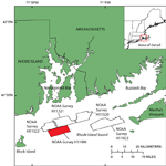
The purpose of this report is to release interpretations of bathymetric, sediment, and photographic data from an area of Rhode Island Sound, located 14 kilometers (km) east-northeast of Block Island, R.I. (fig. 1). The study area covers NOAA survey H11996, which was completed in 2008 and includes 65 square kilometers (km²) of multibeam echosounder data. The bathymetric data were originally collected to update nautical charts, but can also be combined with verification data, collected from the sea floor, in order to interpret sea-floor geology. The USGS completed a ground-truth survey of this area in July 2010, occupying 25 stations where sediment and photographic data were obtained. The bathymetric, sediment, and photographic data are used to describe sedimentary environments and bedforms on the sea floor. Interpretations of these data serve as important resources for benthic habitat studies and provide basemaps for future management projects in Rhode Island Sound. |