U.S. Geological Survey Open-File Report 2011–1005
Surficial Geology of the Sea Floor in Central Rhode Island Sound Southeast of Point Judith, Rhode Island
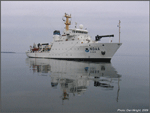
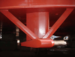
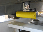
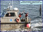
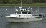
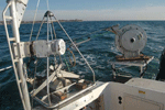
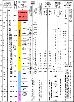
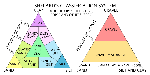
Multibeam echosounder (MBES) data were collected during NOAA survey H11996 onboard the NOAA Ship Thomas Jefferson in September and October of 2008 (fig. 3). A RESON 7125 MBES, with a frequency of 400 kHz, collected bathymetric data on the Thomas Jefferson (fig. 4). A RESON 8125 MBES (fig. 5), with a frequency of 455 kHz, collected bathymetric data on launch 3101, an 8.5-meter (m) aluminum launch deployed from the Thomas Jefferson (fig. 6). Ship positioning was determined by differential global positioning system (DGPS) with corrections from U.S. Coast Guard beacons in Moriches, N.Y., and Acushnet, Mass. MBES data were acquired in extended Triton data format (XTF) and recorded digitally through an ISIS data acquisition system. The data were processed with CARIS Hydrographic Image Processing System (HIPS) software to perform a quality assessment and to incorporate sound velocity and tidal corrections. Sound velocity corrections were derived from SEACAT conductivity-temperature-depth (CTD) profiles. Typically, a CTD cast was conducted once every 3 to 4 hours during MBES acquisition. Water depths are relative to mean lower low water level and were corrected using observed water levels from gages at Newport, R.I., and Menemsha Harbor, Mass. The vertical resolution of the MBES data is approximately 0.5 percent of the water depth. The data were gridded to 2-m resolution and saved as a CARIS HIPS database. Vertically exaggerated (5x), hill-shaded (illuminated from 0° north at an angle of 45°) imagery was created using CARIS HIPS software. Further details on MBES data processing and survey information can be found in the H11996 Descriptive Report (National Oceanic and Atmospheric Administration, 2008). Bathymetric data are not to be used for navigation. A ground-truth survey was completed by the USGS as part of cruise 2010-033-FA on the research vessel (RV) Rafael in July 2010 (fig. 7). In this study area, 25 stations were occupied in order to collect sediment samples and still and video photography using a mini SEABed Observation and Sampling System (SEABOSS), a modified Van Veen grab sampler with attached still and video cameras (fig. 8). One sediment sample from 22 of the 25 stations was obtained from the top 2 centimeters (cm) of the sea floor. Three of the stations did not produce a retrievable sample using the Van Veen sampler because they were too rocky, so these samples were described visually using video and photographic data. Sediment samples were analyzed for grain size at the USGS Woods Hole Coastal and Marine Science Center Sediment Laboratory, Woods Hole, Mass. Sediment descriptions are based on Wentworth's (1922) nomenclature (fig. 9) and Shepard's (1954) size classifications (fig. 10). Grain-size analysis followed the methods detailed in Poppe and others (2005). The fine fractions (diameters less than 0.0625 millimeters (mm)) of samples were analyzed with a Coulter Counter; coarse fractions (diameters greater than or equal to 0.0625 mm) were analyzed with sieves. Sample weights were corrected for salt content. Gravel-sized shells were excluded from the analysis, as they generally form in situ and are not considered to be representative of the sedimentary environment. Sediment data are available in the GIS Data Catalog section of this report. Photographic data include three to seven still photographs and several minutes of video obtained while drifting over the sea floor at each station. The photographs and video are used to observe the sea-floor environment and flora and fauna populations. Low-resolution versions of the still photographs are available to browse in the Bottom Photography section of this report; location information and full-resolution versions of the photographs are available in the GIS Data Catalog section. To view files in PDF format, download a free copy of Adobe Reader.
|