U.S. Geological Survey Open-File Report 2011-1040
Continuous Resistivity Profiling Data From Great South Bay, Long Island, New York
This report contains Geographic Information System (GIS) data in vector format. The vector data are available in Esri shapefile format. Shapefiles generally include .shp, .shx, and .dbf files at a minimum. All the data files include the .prj files, which contain the dataset projection information. For the sake of brevity, only the filename prefix has been included in the column 'Filename' listed below; extensions have been excluded. Clicking on the image in the 'View' column of GIS-compatible data will display a thumbnail image of the dataset. The files necessary to load each dataset into a compatible GIS have been compressed into a single zip file, along with Federal Geographic Data Committee (FGDC)-compliant metadata in text, FAQ, HTML and XML formats. A second XML metadata format generated and viewable by ArcCatalog is also included in the compressed zip file. In addition, the FGDC-compliant text, FAQ, and HTML versions of the metadata for each dataset have links provided below. The data files can be downloaded directly from the tables below. In addition to the GIS data, this report also contains CRP data available in both raw and processed formats. Each line of data acquisition comprises multiple files as described in the Methods section of this report. For this reason, these data are organized by day of collection and are available as compressed zip files for each day of data collection. These download files also contain the FGDC-compliant metadata in text, FAQ, HTML and XML formats. The CRP tracklines can be hyperlinked to associated images within ArcGIS. Within the CRP tracklines shapefile, two text attributes, "hotlink" and "hlink2", can be utilized to hyperlink to the JPEG images of the resistivity profiles. The "hotlink" attribute points to the MATLAB JPEG image, while the "hlink2" attribute points to the long version of the EarthImager 2D JPEG image. The metadata for the trackline file (resgpslns_gsbay) gives further instruction on using the hyperlink feature. The handwritten data acquisition logs maintained during the survey were scanned and converted into the Portable Document Format (PDF). This file along with the FGDC-compliant metadata is available in a compressed zip file available from the table. To download the data from the table below, right mouse click on the link in the 'Download' column. Select 'Save Target As...' to save a compressed zip file to the local hard drive. The download file size is indicated under the file name. Microsoft Windows Millennium Edition and later supports extracting zip files natively without additional third party software. Simply double-click on the file to begin the extraction wizard. In cases where a utility program to uncompress files is needed and not currently installed on the local system, 7-zip (http://www.7-zip.org/) provides an open source utility. These files were compressed with WinZip version 9.0.
|
Basemap (data/basemap/)
| Filename | Data Description | View | Metadata | Download link and file size |
|---|---|---|---|---|
| clipnoaashore | Polyline shapefile from the National Oceanic and Atmospheric Administration of the shoreline in the Long Island, New York area (Geographic coordinate system, North American Datum of 1983 (NAD83)). | 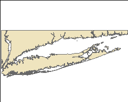 |
clipnoaashore.zip 1.2 MB |
navigation (data/navigation/)
| Filename | Data Description | View | Metadata | Download link and file size |
|---|---|---|---|---|
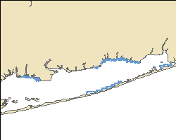
| resgpspnts_gsbay | Point shapefile of all the navigation fixes acquired with the CRP data in Great South Bay in 2008. Only the processed acquisition lines are represented. (Geographic coordinate system, World Geodetic System of 1984 (WGS84)). | 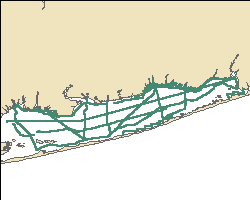 |
resgpspnts_gsbay.zip 0.68 MB |
|
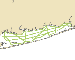
| resgpslns_gsbay | Polyline shapefile showing the tracklines of processed CRP profiles in Great South Bay in 2008 (Geographic coordinate system, WGS84). | 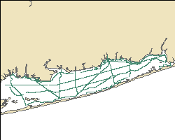 |
resgpslns_gsbay.zip 0.21 MB |
CRP data (data/resistivity/)
| Raw CRP data (data/resistivity/raw_resis/): The zip file contains the raw resistivity data collected by the AGI SuperSting system. This includes the STG and GPS files used directly in processing. The CMD and CRS files are configuration files generated at the time of data acquisition. The subfolder within the zip file indicates date of data collection. |
| Processed CRP data (data/resistivity/proc_resis/): The zip file includes the linearized STG file and accompanying DEP file, EarthImager processed files that used the measured water resistivity value when possible, and the MATLAB-generated profile images. The subfolder within the zip file indicates date of data collection. Uncompressing the file in the data/resistivity/proc_resis/ folder will maintain the appropriate data structure necessary for the hyperlinked images to work. |
| RES2DINV format CRP data (data/resistivity/res2dinv_format/): The zip file includes the RES2DINV format files based on the linearized STG and DEP files of the processed CRP data. The subfolder within the zip file indicates date of data collection. |
See the metadata for more details on the individual file types and how they were generated.
| Filename | Data Description | Metadata | Download link and file size |
|---|---|---|---|
| may19_raw | Raw CRP data from May 19, 2008 in Great South Bay. | may19_raw.zip 0.24 MB |
|
| may20_raw | Raw CRP data from May 20, 2008 in Great South Bay. | may20_raw.zip 0.89 MB |
|
| may21_raw | Raw CRP data from May 21, 2008 in Great South Bay. | may21_raw.zip 0.73 MB |
|
| may22_raw | Raw CRP data from May 22, 2008 in Great South Bay. | may22_raw.zip 0.66 MB |
|
| sept22_raw | Raw CRP data from Sept. 22, 2008 in Great South Bay. | sept22_raw.zip 0.19 MB |
|
| sept23_raw | Raw CRP data from Sept. 23, 2008 in Great South Bay. | sept23_raw.zip 0.53 MB |
|
| sept24_raw | Raw CRP data from Sept. 24, 2008 in Great South Bay. | sept24_raw.zip 0.49 MB |
|
| sept25_raw | Raw CRP data from Sept. 25, 2008 in Great South Bay. | sept25_raw.zip 0.24 MB |
|
| may19_proc | Processed CRP data from May 19, 2008 in Great South Bay. | ||
| may20_proc | Processed CRP data from May 20, 2008 in Great South Bay. | may20_proc.zip 28.5 MB |
|
| may21_proc | Processed CRP data from May 21, 2008 in Great South Bay. | may21_proc.zip 22.3 MB |
|
| may22_proc | Processed CRP data from May 22, 2008 in Great South Bay. | may22_proc.zip 18.0 MB |
|
| sept22_proc | Processed CRP data from Sept. 22, 2008 in Great South Bay. | sept22_proc.zip 6.0 MB |
|
| sept23_proc | Processed CRP data from Sept. 23, 2008 in Great South Bay. | sept23_proc.zip 19.2 MB |
|
| sept24_proc | Processed CRP data from Sept. 24, 2008 in Great South Bay. | sept24_proc.zip 16.7 MB |
|
| sept25_proc | Processed CRP data from Sept. 25, 2008 in Great South Bay. | sept25_proc.zip 7.9 MB |
|
allgsb_resbsed_may08 |
Point shapefile of all the processed resistivity data from Great South Bay collected in May 2008 with data points in the water column removed (Geographic coordinate system, WGS84). | allgsb_resbsed_may08.zip 46.1 MB |
|
allgsb_resbsed_sept08 |
Point shapefile of all the processed resistivity data fromGreat South Bay collected in September 2008 with data points in the water column removed (Geographic coordinate system, WGS84). | allgsb_resbsed_sept08.zip 14.7 MB |
|
| may19_res2dinv | The RES2DINV formatted CRP data from May 19, 2008 in Great South Bay. | may19_res2dinv.zip 0.12 MB |
|
| may20_res2dinv | The RES2DINV formatted CRP data from May 20, 2008 in Great South Bay. | may20_res2dinv.zip 0.53 MB |
|
| may21_res2dinv | The RES2DINV formatted CRP data from May 21, 2008 in Great South Bay. | may21_res2dinv.zip 0.49 MB |
|
| may22_res2dinv | The RES2DINV formatted CRP data from May 22, 2008 in Great South Bay. | may22_res2dinv.zip 0.32 MB |
|
| sept22_res2dinv | The RES2DINV formatted CRP data from Sept. 22, 2008 in Great South Bay. | sept22_res2dinv.zip 0.09 MB |
|
| sept23_res2dinv | The RES2DINV formatted CRP data from Sept. 23, 2008 in Great South Bay. | sept23_res2dinv.zip 0.22 MB |
|
| sept24_res2dinv | The RES2DINV formatted CRP data from Sept. 24, 2008 in Great South Bay. | sept24_res2dinv.zip 0.21 MB |
|
| sept25_res2dinv | The RES2DINV formatted CRP data from Sept. 25, 2008 in Great South Bay. | sept25_res2dinv.zip 0.10 MB |
PDF logs (data/survey_log/)
| Filename | Description | Metadata | Download link and file size |
|---|---|---|---|
| gsb_2008_all | The PDF data acquisition log. | gsb2008_all.zip 4.23 MB |

![]() U.S. Department of the Interior |
U.S. Geological Survey
U.S. Department of the Interior |
U.S. Geological Survey
URL: http://pubsdata.usgs.gov/pubs/of/2011/1040/html/catalog.html
Page Contact Information: GS Pubs Web Contact
Page Last Modified: Thursday, 08-Dec-2016 00:30:08 EST