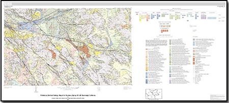
 Introduction Introduction
The Newberry Springs 30’ x 60’ quadrangle is located in the central Mojave Desert of southern California. It is split approximately into northern and southern halves by I-40, with the city of Barstow at its western edge and the town of Ludlow near its eastern edge. The map area spans lat 34°30 to 35° N. to long -116° to -117° W. and covers over 1,000 km². We integrate the results of surficial geologic mapping conducted during 2002–2005 with compilations of previous surficial mapping and bedrock geologic mapping. Quaternary units are subdivided in detail on the map to distinguish variations in age, process of formation, pedogenesis, lithology, and spatial interdependency, whereas pre-Quaternary bedrock units are grouped into generalized assemblages that emphasize their attributes as hillslope-forming materials and sources of parent material for the Quaternary units.
The spatial information in this publication is presented in two forms: a spatial database and a geologic map. The geologic map is a view (the display of an extracted subset of the database at a given time) of the spatial database; it highlights key aspects of the database and necessarily does not show all of the data contained therein. The database contains detailed information about Quaternary geologic unit composition, authorship, and notes regarding geologic units, faults, contacts, and local vegetation. The amount of information contained in the database is too large to show on a single map, so a restricted subset of the information was chosen to summarize the overall nature of the geology. Refer to the database for additional information.
Accompanying the spatial data are the map documentation and spatial metadata. The map documentation (this document) describes the geologic setting and history of the Newberry Springs map sheet, summarizes the age and physical character of each map unit, and describes principal faults and folds. The Federal Geographic Data Committee (FGDC) compliant metadata provides detailed information about the digital files and file structure of the spatial data.
|
-
This report is available only on the Web.
Part of this report is presented in Portable Document Format (PDF); the latest version of Adobe Reader or similar software is required to view it. Download the latest version of Adobe Reader, free of charge. |

