 Abstract Abstract
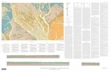
The Elizabethtown 30' × 60' quadrangle is located in southeastern North Carolina between Fayetteville and Wilmington. Most of the area is flat to gently rolling, although steep slopes occur locally along some of the larger streams. Total relief in the area is slightly over 210 feet (ft), with elevations ranging from slightly less than 10 ft above sea level along the Black River (east of Rowan in the southeastern corner of the map) to slightly over 220 ft in the northwestern corner northeast of Hope Mills. The principal streams in the area are the Cape Fear, Black, South, and Lumber Rivers, which on average flow from northwest to southeast across the map area. The principal north-south roads are Interstate Route 95, Interstate Route 40, U.S. Route 117, U.S. Route 301, U.S. Route 421, and U.S. Route 701, and the principal east-west roads are N.C. State Route 241 and N.C. State Route 41. This part of North Carolina is primarily rural and agricultural. The largest communities in and adjacent to the area are Elizabethtown, Hope Mills, Clinton, Warsaw, and Lumberton. The map lies entirely within the Atlantic Coastal Plain physiographic province. Outstanding features of this area are the large number of sand-rimmed Carolina bays, five of which contain enough water to constitute natural lakes: Bay Tree Lake, Salter Lake, Little Singletary Lake, Singletary Lake, and White Lake. These are associated with widespread windblown sand deposits on which are grown abundant crops of blueberries. The extent and distribution of these deposits have been estimated based on a combination of augerhole, outcrop, and light-detection and ranging (LIDAR) data.
The geology of the Elizabethtown 30' × 60' quadrangle was originally mapped on 32 7.5-minute quadrangles at 1:24,000 scale and then compiled on this 1:100,000-scale base. The base-map topographic contours on this compilation are shown in meters; the cross sections, structure contours, and well and corehole basement elevations have been carried over unconverted from the 1:24,000-scale maps and are shown in feet.
|
First posted July 26, 2011
Part or all of this report is presented in Portable Document Format (PDF); the latest version of Adobe Reader or similar software is required to view it. Download the latest version of Adobe Reader, free of charge. |

