U.S. Geological Survey, 2012, H11999OUTLINE.SHP: Outline of the Multibeam-Bathymetric Data Collected During National Oceanic and Atmospheric Administration (NOAA) Survey H11999 (Geographic, WGS84): Open-File Report 2011-1149, U.S. Geological Survey, Coastal and Marine Geology Program, Woods Hole Coastal and Marine Science Center, Woods Hole, MA.This is part of the following larger work.Online Links:
- <https://pubs.usgs.gov/of/2011/1149/data/basemaps/outline/h11999outline.zip>
- <https://pubs.usgs.gov/of/2011/1149/data/basemaps/outline/>
- <https://pubs.usgs.gov/of/2011/1149/html/catalog.html>
McMullen, K.Y., Poppe, L.J., Danforth, W.W., Blackwood, D.S., Schaer, J.D., Glomb, K.A., and Doran, E.F., 2012, Sea-Floor Geology of Long Island Sound North of Duck Pond Point, New York: Open-File Report 2011-1149, U.S. Geological Survey, Coastal and Marine Geology Program, Woods Hole Coastal and Marine Science Center, Woods Hole, MA.Online Links:
This is a Vector data set. It contains the following vector data types (SDTS terminology):
Horizontal positions are specified in geographic coordinates, that is, latitude and longitude. Latitudes are given to the nearest 0.000001. Longitudes are given to the nearest 0.000001. Latitude and longitude values are specified in Decimal degrees.
The horizontal datum used is D_WGS_1984.
The ellipsoid used is WGS_1984.
The semi-major axis of the ellipsoid used is 6378137.000000.
The flattening of the ellipsoid used is 1/298.257224.
Sequential unique whole numbers that are automatically generated.
Coordinates defining the features.
| Value | Definition |
|---|---|
| 105.540558877 | Area of polygon (study area) in square kilometers |
508-548-8700 x2277 (voice)
508-457-2310 (FAX)
kmcmullen@usgs.gov
To release an outline of the multibeam-bathymetric data generated during NOAA survey H11999 north of Duck Pond Point, New York, in geographic.
Person who carried out this activity:
508-548-8700 x2277 (voice)
508-457-2310 (FAX)
kmcmullen@usgs.gov
Data sources produced in this process:
Person who carried out this activity:
508-548-8700 x2277 (voice)
508-457-2310 (FAX)
kmcmullen@usgs.gov
Data sources produced in this process:
Person who carried out this activity:
508-548-8700 x2277 (voice)
508-547-2310 (FAX)
kmcmullen@usgs.gov
Data sources produced in this process:
Schattgen, P. Tod , 2008, H11999: Descriptive Report H11999, National Ocean Survey, National Oceanic and Atmospheric Administration, Atlantic Hydrographic Branch, Norfolk, VA.Online Links:
Poppe, L.J., McMullen, K.Y., Ackerman, S.D., Blackwood, D.S., Irwin, B.J., Schaer, J.D., Lewit, P.G., and Doran, E.F., 2010, Sea-Floor Geology and Character Offshore of Rocky Point, New York: Open-File Report 2010-1007, U.S. Geological Survey, Coastal and Marine Geology Program, Woods Hole Coastal and Marine Science Center, Woods Hole, MA.Online Links:
Poppe, L.J., DiGiacomo-Cohen, M.L., Doran, E.F., Smith, S.M., Stewart, H.F., and Forfinski, N.A., 2007, Geologic interpretation and multibeam bathymetry of the sea floor in the vicinity of the Race, eastern Long Island Sound: Open-File Report 2007-1012, U.S. Geological Survey, Coastal and Marine Geology Program, Woods Hole Coastal and Marine Science Center, Woods Hole, MA.Online Links:
Poppe, L.J., Denny, J.F., Williams, S.J., Moser, M.S., Forfinski, N.A., Stewart, H.F., and Doran, E.F., 2007, The geology of Six Mile Reef, eastern Long Island Sound: Open-File Report 2007-1191, U.S. Geological Survey, Coastal and Marine Geology Program, Woods Hole Coastal and Marine Science Center, Woods Hole, MA.Online Links:
McMullen, K.Y., Poppe, L.J., Danforth, W.W., Blackwood, D.S., Schaer, J.D., Ostapenko, A.J., Glomb, K.A., and Doran, E.F., 2010, Surficial Geology of the Sea Floor in Long Island Sound Offshore of Plum Island, New York: Open-File Report 2010-1005, U.S. Geological Survey, Coastal and Marine Geology Program, Woods Hole Coastal and Marine Science Center, Woods Hole, MA.Online Links:
McMullen, K.Y., Poppe, L.J., Danforth, W.W., Blackwood, D.S., Schaer, J.D., Guberski, M.R., Wood, D.A., and Doran, E.F., 2011, Surficial Geology of the Sea Floor in Long Island Sound Offshore of Orient Point, New York: Open-File Report 2010-1100, U.S. Geological Survey, Coastal and Marine Geology Program, Woods Hole Coastal and Marine Science Center, Woods Hole, MA.Online Links:
Horizontal positional accuracy is based on Differential GPS.
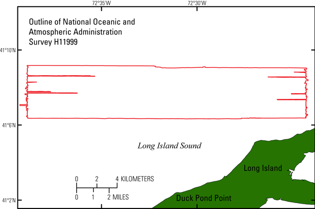
This data layer shows the extent and locations of the areas surveyed during NOAA cruise H11999
No additional checks for consistency were performed on this data.
Are there legal restrictions on access or use of the data?
- Access_Constraints: None
- Use_Constraints:
- Public domain data are freely redistributable with proper metadata and source attribution. Please recognize the U.S. Geological Survey (USGS) as the originator of this information.
508-548-8700 x2314 (voice)
508-457-2310 (FAX)
lpoppe@usgs.gov
Downloadable Data
Neither the U.S. Government, the Department of the Interior, nor the USGS, nor the National Oceanic and Atmospheric Administration (NOAA), nor any of their employees, contractors, or subcontractors, make any warranty, express or implied, nor assume any legal liability or responsibility for the accuracy, completeness, or usefulness of any information, apparatus, product, or process disclosed, nor represent that its use would not infringe on privately owned rights. The act of distribution shall not constitute any such warranty, and no responsibility is assumed by the USGS or NOAA in the use of these data or related materials. Any use of trade, product, or firm names is for descriptive purposes only and does not imply endorsement by the U.S. Government.
| Data format: | The shapefile (h11999outline.shp, h11999outline.shx, h11999outline.dbf, h11999outline.prj), browse graphic, and metadata. in format SHP (version 3.3) ESRI polygon shapefile Size: 36 KB |
|---|---|
| Network links: |
<https://pubs.usgs.gov/of/2011/1149/data/basemaps/outline/h11999outline.zip> <https://pubs.usgs.gov/of/2011/1149/data/basemaps/outline/> <https://pubs.usgs.gov/of/2011/1149/html/catalog.html> |
| Media you can order: |
DVD-ROM
(Density 4.75
Gbytes)
(format UDF)
|
These data are available in Environmental Systems Research Institute (ESRI) shapefile format. The user must have ArcGIS or ArcView 3.0 or greater software to read and process the data file. In lieu of ArcView or ArcGIS, the user may utilize another GIS application package capable of importing data. A free data viewer, ArcExplorer, capable of displaying the data is available from ESRI at www.esri.com. The user must have software capable of uncompressing archived zip files, such as Winzip or Pkware.
508-548-8700 x2277 (voice)
508-457-2310 (FAX)
kmcmullen@usgs.gov