 |
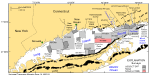
Figure 1. Index map of the Long Island Sound study area (H11999), U.S. Geological Survey (USGS)/Connecticut Department of Environmental Protection (CTDEP) surveys, and National Oceanic and Atmospheric Administration (NOAA) hydrographic surveys. NOAA hydrographic surveys include H11250—Poppe and others (2006c, 2007b); H11255—Poppe and others (2006b); H11252/H11361—Poppe and others (2007a, 2008); H11043—Poppe and others (2004a); H11044—McMullen and others (2005), Poppe and others (2006a); H11045—Beaulieu and others (2005);
H11441/H11442/H11224/H11225—Poppe and others (2010a); H11251—Poppe and others (2010b); H11445—McMullen and others (2010); H11446—McMullen and others (2011); and H11997—Poppe and others (2011b). USGS/CTDEP sidescan-sonar surveys include Norwalk—Twichell and others (1997); Milford—Twichell and others (1998); New Haven Harbor and Central Long Island Sound (CLIS) Dumping Grounds—Poppe and others (2001); Roanoke Point—Poppe and others (1999b); Falkner Island—Poppe and others (1999a); Hammonasset—Poppe and others (1997); Niantic Bay—Poppe and others (1998b); New London—Lewis and others (1998), Zajac and others (2000, 2003); Fishers Island Sound—Poppe and others (1998a). End moraines are represented as solid black polygons and are labeled in detail in figure 2. |
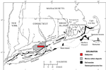 |
Figure 2. Map showing the location of end moraines, submerged moraine lines in southern New York and New England (modified from Gustavson and Boothroyd, 1987), and the extent of marine deltaic deposits from the Connecticut River (Lewis and DiGiacomo-Cohen, 2000). The Ronkonkoma-Block Island-Nantucket end moraine represents the maximum advance of the Laurentide Ice Sheet about 20,000 years ago, and the Harbor Hill-Roanoke Point-Charleston-Buzzards Bay end moraine represents a retreated ice-sheet position from about 18,000 years ago (Uchupi and others, 2001). |
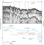 |
Figure 3. Seismic-reflection profile from line 38 of U.S. Geological Survey cruise 82-3 aboard the Woods Hole Oceanographic Institute research vessel Asterias, with interpretation (Lewis and Needell, 1987). The line crosses the eastern part of the study area and shows sand waves and a scour depression on the sea floor. The scour depression has eroded into underlying post-glacial marine sediments, which are probably mostly deltaic. This unit is underlain by a marine unconformity and glaciolacustrine sediments. In the southwestern part of the line segment, undifferentiated glacial drift (probably the flank of the Harbor Hill-Roanoke Point-Orient Point moraine segment) crops out. Location of seismic profile shown in figure 16. |
 |
Figure 4. Photograph showing the National Oceanic and Atmospheric Administration Ship Thomas Jefferson. |
 |
Figure 5. Photograph showing the National Oceanic and Atmospheric Administration launch 3102. |
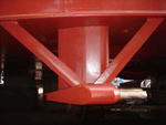 |
Figure 6. Photograph showing a RESON SeaBat 7125 used to collect bathymetric data on National Oceanic and Atmospheric Administration Ship Thomas Jefferson during survey H11999. |
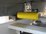 |
Figure 7. Photograph showing a RESON SeaBat 8125 used to collect bathymetric data on National Oceanic and Atmospheric Administration launch 3101 during survey H11999. |
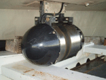 |
Figure 8. Photograph showing a RESON SeaBat 8101 used to collect bathymetric data on National Oceanic and Atmospheric Administration launch 3102 during survey H11999. |
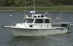 |
Figure 9. Photograph showing the U.S. Geological Survey (USGS) research vessel Rafael used to collect bottom photographs and sediment samples on USGS cruise 2010-010-FA. |
 |
Figure 10. Photograph showing the U.S. Environmental Protection Agency ocean survey vessel Bold used to collect bottom photographs and sediment samples on U.S. Geological Survey cruise 2010-015-FA. |
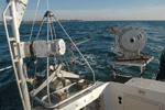 |
Figure 11. Photograph showing the small SEABed Observation and Sampling System (SEABOSS), a modified Van Veen grab sampler equipped with still and video photographic systems, mounted on the aft starboard side of the U.S. Geological Survey (USGS) research vessel Rafael. The system uses a winch, mounted on a davit (left), and a take-up reel for the video-signal and power cable (right). The small SEABOSS was used on USGS cruise 2010-010-FA; a larger version of this device, the mid-sized SEABOSS was used on USGS cruise 2010-015-FA. |
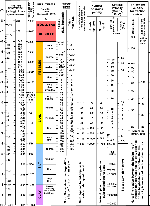 |
Figure 12. Chart showing the relations among phi sizes, millimeter diameters, size classifications (Wentworth, 1922), and American Society for Testing and Materials and Tyler sieve sizes. Chart also shows the corresponding intermediate diameters, grains per milligram, settling velocities, and threshold velocities for traction. cm/sec, centimeter per second; m, meter; mm millimeter; µm, micrometer; ", inch. |
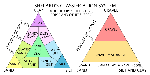 |
Figure 13. Charts showing a sediment-classification scheme from Shepard (1954), as modified by Schlee (1973) and Poppe and others (2004b). |
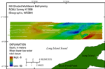 |
Figure 14. Hill-shaded multibeam bathymetry and map showing the study area for National Oceanic and Atmospheric Administration survey H11999. Warmer colors (reds) are shallower areas; cooler colors (blues) are deeper areas. WGS84, World Geodetic System 1984. |
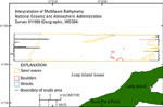 |
Figure 15. Map showing interpretation of sea-floor features in the multibeam bathymetry from National Oceanic and Atmospheric Administration survey H11999. WGS84, World Geodetic System 1984. |
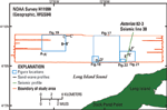 |
Figure 16. Map showing the location of figures and sand-wave and seismic profiles in the study area. NOAA, National Oceanic and Atmospheric Administration; WGS84, World Geodetic System 1984. |
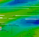 |
Figure 17. Detailed multibeam bathymetry image showing two elongate depressions and sand-wave fields in the eastern part of the study area. The sand-wave fields end abruptly in these depressions. Some sand waves have well-aligned crests that form rows perpendicular to the crest orientations. Location of image shown in figure 16. |
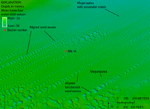 |
Figure 18. Detailed multibeam bathymetry image showing lines of sand waves that are mostly barchanoid sand waves in the southwest, which grade into sinusoidal-crested megaripples in the northeast. Location of image shown in figure 16. |
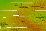 |
Figure 19. Detailed multibeam bathymetry image showing sand waves and megaripples in the western part of the study area, including arced, bifurcated, and sinusoidal morphologies. Location of image shown in figure 16. |
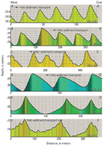 |
Figure 20. Charts showing profiles of sand waves in the study area. A-A' through D-D' show sand waves with asymmetries that indicate net sediment transport to the west. E-E' shows relatively symmetrical sand waves that suggest no dominant sediment transport direction. F-F' shows asymmetrical sand waves indicative of eastward net sediment transport. VE, vertical exaggeration. Location of profiles shown in figure 16. |
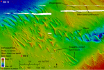 |
Figure 21. Detailed multibeam bathymetry image showing straight-crested and bifurcated sand waves in the southern part of the study area. Moats often form at the ends of the straight-crested sand waves. Megaripples are also present in this area. Location of image shown in figure 16. |
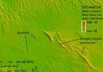 |
Figure 22. Detailed multibeam bathymetry image showing an area of boulders in the southern part of the study area. Sand waves are also visible. Location of image shown in figure 16. |
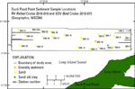 |
Figure 23. Map showing location of sediment samples collected during U.S. Geological Survey cruises 2010-010, aboard research vessel (RV) Rafael, and 2010-015, aboard U.S. Environmental Protection Agency ocean survey vessel (OSV) Bold, north of Duck Pond Point, New York. Most samples are sand, one is gravelly sediment and another is sand silt clay. WGS84, World Geodetic System 1984. |
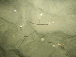 |
Figure 24. Photograph showing the sea floor at station 999-13 with rippled sand. Shell debris and fine-grained sediment are concentrated in the ripple troughs. The field of view of each image is approximately 50 centimeters. Location of photograph shown in figure 27. |
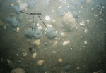 |
Figure 25. Photograph of the sea floor at station 999-6 showing mud clasts scattered on the sea floor. Sand and shells are also present. The field of view of each image is approximately 50 centimeters. Location of photograph shown in figure 27. |
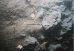 |
Figure 26. Photograph of the sea floor at station 999-6 showing an outcrop of gray cohesive mud on the wall of a scour depression. The fine-grained texture and the position of this deposit above the marine unconformity suggest that it records distal deposition on the marine delta (Lewis and DiGiacomo-Cohen, 2000). The field of view of each image is approximately 50 centimeters. Location of photograph shown in figure 27. |
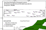 |
Figure 27. Map showing location of bottom photographs taken during U.S. Geological Survey research vessel (RV) Rafael cruise 2010-010 and U.S. Environmental Protection Agency ocean survey vessel (OSV) Bold cruise 2010-015 north of Duck Pond Point, New York. WGS84, World Geodetic System 1984. |


