Skip past header information
USGS - science for a changing world
NOAA Logo with link to NOAA Home Page.Massachusetts CZM Logo with link to MA CZM Home Page.  

U.S. Geological Survey Open-File Report 2011–1222

Sea-Floor Geology and Sedimentary Processes in the Vicinity of Cross Rip Channel, Nantucket Sound, Offshore Southeastern Massachusetts


Bathymetry

Skip past contents information
Click on figures for larger images
Thumbnail image of figure 3 and link to larger figure. Image of Uniboom seismic-reflection profile.
Figure 3. Segment of Uniboom seismic-reflection profile collected across the northwestern part of the study area.
Thumbnail image of figure 4 and link to larger figure. Image of Uniboom seismic reflection profile.
Figure 4. Segment of Uniboom seismic-reflection profile collected across the eastern extension of Cross Rip Shoal.
Thumbnail image of figure 18 and link to larger figure. A map showing the bathymetry of the study area.
Figure 18. Digital terrain model of the sea floor produced from multibeam bathymetry collected during National Oceanic and Atmospheric Administration survey H12007 in central Nantucket Sound, offshore southeastern Masscahusetts.
Thumbnail image of figure 19 and link to larger figure. A map showing locations of figures.
Figure 19. Locations of detailed planar views of the digital terrain model (yellow polygons), Uniboom seismic-reflection profiles shown in figures 3 and 4 (red lines), and bathymetric profiles of bedform morphology (blue lines) shown in figures 26, 27, and 29.
Thumbnail image of figure 20 and link to larger figure. An image showing the sea floor in the axis of Cross Rip Channel.
Figure 20. Detailed planar view of the bathymetric data collected during National Oceanic and Atmospheric Administration survey H12007 showing the sea floor along the axis of Cross Rip Channel.
Thumbnail image of figure 21 and link to larger figure. An image of bathymetric data showing boulders.
Figure 21. Detailed planar view of the bathymetric data collected during National Oceanic and Atmospheric Administration survey H12007 showing boulders on the sea floor along within Cross Rip Channel.
Thumbnail image of figure 22 and link to larger figure. A map showing the interpretation of the bathymetry of the study area.
Figure 22. Interpretation the bathymetric data collected during National Oceanic and Atmospheric Administration survey H12007 as verified by sampling and bottom photography during U.S. Geological Survey cruise 2011-006-FA.
Thumbnail image of figure 23 and link to larger figure. An image of bathymetric data showing the southern flank of Horseshoe Shoal.
Figure 23. Detailed planar view of the bathymetric data collected during National Oceanic and Atmospheric Administration survey H12007 showing southern flank of Horseshoe Shoal and the location of station CR13.
Thumbnail image of figure 24 and link to larger figure. An image of bathymetric data showing megaripples and sand waves.
Figure 24. Detailed planar view of the bathymetric data collected during National Oceanic and Atmospheric Administration survey H12007 extending across the eastern part of Cross Rip Shoal and the locations of stations CR9 and CR10.
Thumbnail image of figure 25 and link to larger figure. An image of bathymetric data showing sand waves on Halfmoon Shoal.
Figure 25. Detailed planar view of the bathymetric data collected during National Oceanic and Atmospheric Administration survey H12007 showing the southwestern part of Halfmoon Shoal and the location of station CR16.
Thumbnail image of figure 26 and link to larger figure. An image of cross-sectional views of sand waves in the study area.
Figure 26. Cross sectional views of sand waves produced from the bathymetric data collected during National Oceanic and Atmospheric Administration survey H12007 showing bedform asymmetry along the flanks of Horseshoe Shoal and Cross Rip Shoal.
Thumbnail image of figure 27 and link to larger figure. Cross sections of sand waves in the study area.
Figure 27. Cross sectional views of sand waves produced from the bathymetric data collected during National Oceanic and Atmospheric Administration survey H12007 from the crest and across the western flanks of the extension of Cross Rip Shoal and Halfmoon Shoal.
Thumbnail image of figure 28 and link to larger figure. Image of bathymetric data showing megaripples in the southeastern part of the study area.
Figure 28. Detailed planar view of the bathymetric data collected during National Oceanic and Atmospheric Administration survey H12007 showing the southeastern part of the study area and the location of station CR20.
Thumbnail image of figure 29 and link to larger figure. Cross sectional view of megaripples in the study area.
Figure 29. Cross sectional views of megaripples from the digital terrain model produced from bathymetric data collected during National Oceanic and Atmospheric Administration survey H12007 from the southeastern part of the study area.

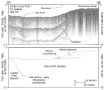
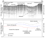
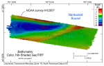
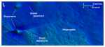
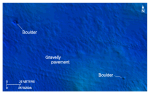
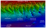
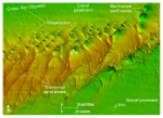
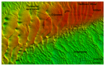
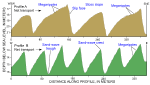
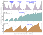
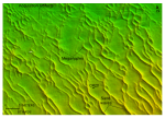
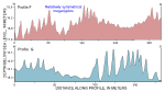
Surveyed depths within the study area range from less than 5 m to more than 26 m (fig. 18). Depths are shallowest on Horseshoe, Cross Rip, and Halfmoon Shoals; depths are greatest along the axis of Cross Rip Channel thalweg. Another prominent feature is the narrow (as little as 160 m wide), elongate bathymetric high that extends northeastward across the study area from Cross Rip Shoal. This elongate bathymetric high connects Cross Rip Shoal with Halfmoon Shoal and separates Cross Rip Channel from the relatively flatter southeast section of the study area.

Sea-floor features visible in the DTM can be geologically interpreted, and the associated on-going sedimentary processes can be identified, because they are morphologically distinct. For example, flat, relatively featureless patches scattered along Cross Rip Channel are interpreted to be gravel pavements that armor the sea floor and limit further erosion (figs. 19, 20). Several small, individual, rounded bathymetric highs are also present in the western part of the channel (fig. 21). These features, up to 5 m in width, are interpreted to be boulders. Seismic profiles show that the Holocene section in this area is thin or absent and that these pavements and boulders are exposures of the winnowed Pleistocene surface (fig. 3). Similarly, seismic profiles from the southwestern part of the study area show that the flat, relatively featureless areas in the southwestern part of the study area are also areas where the Holocene section is thin or absent (fig. 4).

Smaller scale scour depressions within the study area are commonly associated with obstacles on the sea floor, providing evidence of ongoing erosion by the strong, oscillating tidal currents. For example, swirling currents develop around obstacles and the resulting turbulence causes increased flow velocity sufficient to scour the sea floor downstream from obstructions and to produce coarse-sediment-floored, sharp-pointed depressions called obstacle marks, also known as comet marks (Werner and Newton, 1975). A good example of these bedforms is present around the shipwreck in the western part of Cross Rip Channel (fig. 20). Asymmetry of the scour around this wreck indicates that the flood tide is stronger than the ebb tide and that net transport is predominantly toward the east (Reineck and Singh, 1980).

Elsewhere, most of the study area's benthic bathymetric complexity consists of the alternating narrow elongate bathymetric highs and lows revealing the crests and troughs of adjacent sand waves and megaripples (fig. 22). These bedforms, which together cover more than 70 percent of the study area's sea floor, occur in transverse and barchanoid morphologies. Transverse morphologies are on the crests and upper flanks of Horseshoe, Cross Rip, and Halfmoon Shoals where the sediment supply is relatively more abundant (figs. 23, 24, 25). Barchanoid forms are more common on the lower flanks of these shoals within Cross Rip Channel where the sediment supply is more limited. Megaripples are common on the stoss slopes of the sand waves and bottom photography shows that current ripples are common on the megaripples. Together these bedforms are evidence that transport is active and ongoing (Allen, 1968). Bathymetric profiles across the sand waves on the shoals and on the eastern part of the elongate bathymetric high extending from Cross Rip Shoal to Halfmoon Shoal show that these bedforms are asymmetrical, and that the asymmetry indicates eastward net sediment transport (figs. 26, 27; Ludwick, 1972; Dalrymple and others, 1978; Allen, 1980; Reineck and Singh, 1980). One exception is the western end of the elongate bathymetric high, where the bedforms are more commonly symmetrical.

Megaripples are more common than sand waves in the southeastern part of the study area (fig. 28). Bedform crests there tend to be more sinuous and commonly bifurcate and rejoin. Bathymetric profiles across these megaripples show that they are predominantly symmetrical, suggesting that there is less net sediment transport in this area (fig. 29).

Anthropogenic artifacts visible on the DTM include four shipwrecks, the largest of which exceeds 30 m (figs. 20, 23, 25). Artifacts produced by equipment issues and oceanographic conditions prevalent during multibeam acquisition are made more conspicuous by the sun illumination and 5x vertical exaggeration of the imagery (figs. 23, 25).

Skip USGS links group

Accessibility FOIA Privacy Policies and Notices

Take Pride in America logo USAGov logo U.S. Department of the Interior | U.S. Geological Survey
End of USGS links group