U.S. Geological Survey Open-File Report 2011–1222
Sea-Floor Geology and Sedimentary Processes in the Vicinity of Cross Rip Channel, Nantucket Sound, Offshore Southeastern Massachusetts
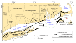
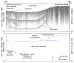
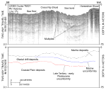
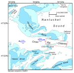
Nantucket Sound is a roughly 48-km long by 40-km wide semi-enclosed body of water offshore of southeastern Massachusetts. It is bordered by Cape Cod on the north, Nantucket on the southeast, and Martha's Vineyard on the west. Between Cape Cod and Martha's Vineyard it is connected to the Vineyard Sound, and it has openings to the Atlantic Ocean to the east and southwest. Nantucket Sound also contains important ecological, commercial, and recreational resources and is a recognized habitat for many state and federally protected species, including roseate terns, piping plovers, leatherback turtles, loggerhead turtles, Kemp's Ridley turtles, and grey seals (Center for Coastal Studies, 2003). The surficial geology and topography of Nantucket Sound are products of glacial processes during the Pleistocene Epoch and a storm- and tidally dominated marine regime during the Holocene sea-level rise. At least two glaciations, the Illinoian (350-125 ka) and the late Wisconsinan, crossed southeastern New England, eroding coastal plain deposits and the underlying bedrock (Oldale, 2001). The late Wisconsinan Laurentide ice sheet reached its maximum extent and southernmost position about 20 to 24 ka, as marked by terminal moraines on Martha's Vineyard and Nantucket and the southern limit of abundant gravel on the adjacent sea floor (Schlee and Pratt, 1970; Uchupi and others, 1996; Oldale, 2001; fig. 2). This lobate ice front was formed by the Buzzards Bay lobe that deposited the moraine along the western part of Martha's Vineyard and the Cape Cod Bay lobe that deposited the moraines across eastern Martha's Vineyard and Nantucket (Oldale and Barlow, 1986; Oldale, 2001). A warming climate after the glacial maxima caused widespread retreat of the ice sheet, but a cold episode shortly prior to 18 ka caused a readvance (Oldale, 2001; Boothroyd, 2001). The Buzzards Bay lobe readvanced to a position along the Elizabeth Islands, creating the Buzzards Bay moraine, and the Cape Cod Bay lobe to a position along the northern edge of Cape Cod, creating the Sandwich moraine (Oldale and O'Hara, 1984). During this time the main part of Cape Cod was deposited as the Barnstable outwash plain, a proglacial lake occupied much of present day Nantucket Sound, and sediments were transported into this lake by meltwater streams flowing southward across the Barnstable outwash plain. Just after 18 ka, the climate warmed again and northward retreat of the ice fronts resumed (Uchupi and others, 1996). The Holocene rise in sea level has conspicuously altered the geology and morphology of Nantucket Sound. Waves and currents reworked the glacial drift and produced a transgressive unconformity as the shoreline migrated across the Sound (O'Hara and Oldale, 1987; figs. 3, 4). Today, strong tidal- and storm-driven currents continue to shape the modern sea floor. The ebb tide flows west across the study area at about 1 knot, but the flood tide is stronger, flowing east at about 1.5 knots (White and White, 2010). Where the glacial drift is exposed, it is winnowed by these currents, producing lag deposits of coarse sand and gravel. The finer grained sand winnowed from the drift now blankets much of the surrounding sea floor and, in places, has been deposited in thick accumulations that form shoals, which continue to be shaped and maintained by the tidal regime. Three of these shoals (Cross Rip Shoal, Horseshoe Shoal, and Halfmoon Shoal) border a linear depression referred to as Cross Rip Channel (fig. 5). |