Skip Links

USGS - science for a changing world
NOAA Logo

Open-File Report 2012–1004

Sea-Floor Geology in Central Rhode Island Sound South of Sakonnet Point, Rhode Island

By K.Y. McMullen, L.J. Poppe, S.D. Ackerman, C.R.Worley, M.A. Nadeau, and M.V. Van Hoy

Thumbnail of and link to Title Page (10 KB)Abstract

The U.S. Geological Survey (USGS) and the National Oceanic and Atmospheric Administration (NOAA) are working together to study the sea floor along the northeastern coast of the United States. NOAA collected multibeam-echosounder data during hydrographic survey H11995 in a 63-square-kilometer area in central Rhode Island Sound, south of Sakonnet Point, Rhode Island. The USGS collected sediment samples, bottom video, and still photographs from 27 stations in this study area to verify an interpretation of the bathymetric data. Collected data are used to map areas of scour depressions and erosional outliers, megaripples, boulders, and relatively undisturbed modern marine sediments. In general, much of the eastern part of the study area, a submerged segment of the Harbor Hill-Roanoke Point-Charlestown-Buzzards Bay moraine, is bouldery. Bottom photography shows boulders are generally encrusted with hydrozoans, algae, and anemone. Scour depressions, presumably formed by long-period storm waves, and erosional outliers of Holocene sediments dominate the western part of the study area and several large areas in the east. The scour depressions tend to have coarser grained sediment than intervening erosional outliers. The coarseness likely creates turbulence in the water over these areas, which prevents fine-grained sediment deposition. Several small areas of megaripples are visible in the bathymetry data in the west. Other sandy areas are typically rippled, with burrows, worm tubes, and starfish present.

First posted August 7, 2012

For additional information contact:
Director
U.S. Geological Survey
Woods Hole Coastal and Marine Science Center
384 Woods Hole Road
Quissett Campus
Woods Hole, MA 02543
(508) 548–8700

Part or all of this report is presented in Portable Document Format (PDF); the latest version of Adobe Reader or similar software is required to view it. Download the latest version of Adobe Reader, free of charge.


Suggested citation:

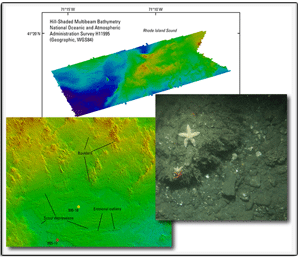
McMullen, K.Y., Poppe, L.J., Ackerman, S.D., Worley, C.R., Nadeau, M.A., and Van Hoy, M.V., 2012, Sea-floor geology in central Rhode Island Sound south of Sakonnet Point, Rhode Island: U.S. Geological Survey Open-File Report 2012–1004, DVD-ROM. (Also available at http://pubs.usgs.gov/of/2012/1004/.)


Accessibility FOIA Privacy Policies and Notices

Take Pride in America logo USA.gov logo U.S. Department of the Interior | U.S. Geological Survey
URL: http://pubsdata.usgs.gov/pubs/of/2012/1004/index.html
Page Contact Information: GS Pubs Web Contact
Page Last Modified: Saturday, 12-Jan-2013 15:23:43 EST