Poppe, Larry, 2012, 2011_006_BISBOTPHOTOS.SHP: Locations of Sea-Floor Photographs Acquired During U.S. Geological Survey (USGS) Cruise 2011-006-FA in Block Island Sound (Geographic, WGS84): Open-File Report 2012-1005, U.S. Geological Survey, Coastal and Marine Geology Program, Woods Hole Coastal and Marine Science Center, Woods Hole, MA.This is part of the following larger work.Online Links:
- <http://pubs.usgs.gov/of/2012/1005/data/botphotos/2011_006_bisbotphotos.zip>
- <http://pubs.usgs.gov/of/2012/1005/data/botphotos/2011_006_bisbotphotos.txt>
- <http://pubs.usgs.gov/of/2012/1005/data/botphotos/2011_006_bisbotphotos.xls>
- <http://pubs.usgs.gov/of/2012/1005/html/catalog.html>
Poppe, L.J., Danforth, W.W, McMullen, K.Y., Blankenship, M.A., Glomb, K.A., Wright, D.B., and Smith, S.M., 2012, Sea-Floor Character and Sedimentary Processes of Block Island Sound, Offshore Rhode Island: Open-File Report 2012-1005, U.S. Geological Survey, Coastal and Marine Geology Program, Woods Hole Coastal and Marine Science Center, Woods Hole, MA.Online Links:
This is a Vector data set. It contains the following vector data types (SDTS terminology):
Horizontal positions are specified in geographic coordinates, that is, latitude and longitude. Latitudes are given to the nearest 0.000001. Longitudes are given to the nearest 0.000001. Latitude and longitude values are specified in Decimal degrees.
The horizontal datum used is D_WGS_1984.
The ellipsoid used is WGS_1984.
The semi-major axis of the ellipsoid used is 6378137.000000.
The flattening of the ellipsoid used is 1/298.257224.
Sequential unique whole numbers that are automatically generated.
Coordinates defining the features.
Characters and numerics identifying sampling sites
Characters and numerics identifying photos
Character String: Months, days, and year as m/dd/yyyy
| Range of values | |
|---|---|
| Minimum: | 41.121957 |
| Maximum: | 41.316065 |
| Units: | Decimal degrees |
| Resolution: | 0.000001 |
| Range of values | |
|---|---|
| Minimum: | -71.850760 |
| Maximum: | -71.388135 |
| Units: | Decimal degrees |
| Resolution: | 0.000001 |
| Value | Definition |
|---|---|
| SMALL SEABOSS GRAB | USGS Small Seabed Observation and Sampling System (SEABOSS) |
| Value | Definition |
|---|---|
| 2011-006-FA | Ship and field activity serial number assigned by Woods Hole Coastal and Marine Science Center data archives |
| Value | Definition |
|---|---|
| BLOCK ISLAND SOUND | Project name assigned by Woods Hole Science Center data archives |
| Value | Definition |
|---|---|
| LPOPPE | Larry Poppe |
(508) 548-8700 x2314 (voice)
(508) 457-2310 (FAX)
lpoppe@usgs.gov
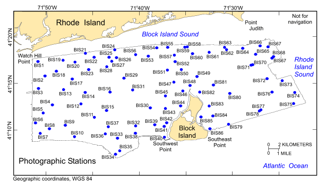
The purpose of this dataset is to release the locations and identifiers of 406 bottom photographs collected at 86 stations on bathymetric data of the sea floor in Block Island Sound, offshore southwestern Rhode Island. The photos were collected with a modified Van Veen grab sampler modified to carry still and video camera systems (small SEABOSS) during USGS survey 2011-006-FA, conducted June 2011.
Person who carried out this activity:
(508) 548-8700 x2314 (voice)
(508) 457-2310 (FAX)
lpoppe@usgs.gov
Data sources produced in this process:
Person who carried out this activity:
508-548-8700 x2314 (voice)
508-457-2310 (FAX)
lpoppe@usgs.gov
Data sources produced in this process:
Blackwood, D., and Parolski, K., 2001, Seabed Observation and Sampling System: Sea Technology v. 42, no. 2, p. 39-43.
Poppe, L.J., Ackerman, S.D., Foster, D.S., Blackwood, D.S., Butman, B., Moser, M.S., and Stewart, H.F., 2007, Sea-floor character and surface processes in the vicinity of Quicks Hole, Elizabeth Islands, Massachusetts: Open-File Report 2006-1357, U.S. Geological Survey, Coastal and Marine Geology Program, Woods Hole Coastal and Marine Science Center, Woods Hole, MA.Online Links:
Poppe, L.J., Ackerman, S.D., Foster, D.S., Blackwood, D.S., Williams, S.J., Moser, M.S., Stewart, H.F., and Glomb, K.A., 2007, Sea-floor character and sedimentary processes of Great Round Shoal Channel, offshore Massachusetts: Open-File Report 2007-1138, U.S. Geological Survey, Coastal and Marine Geology Program, Woods Hole Coastal and Marine Science Center, Woods Hole, MA.Online Links:
Poppe, L.J., McMullen, K.Y., Foster, D.S., Blackwood, D.S., Williams, S.J., Ackerman, S.D., Barnum, S.R., and Brennan, R.T., 2008, Sea-floor character and sedimentary processes in the vicinity of Woods Hole, Massachusetts: Open-File Report 2008-1004, U.S. Geological Survey, Coastal and Marine Geology Program, Woods Hole Coastal and Marine Science Center, Woods Hole, MA.Online Links:
Poppe, L.J., McMullen, K.Y., Ackerman, S.D., Blackwood, D.S., Irwin, B.J., Schaer, J.D., and Forrest, M.R., 2011, Sea-floor geology and character of eastern Rhode Island Sound west of Gay Head, Massachusetts: Open-File Report 2011-1004, U.S. Geological Survey, Coastal and Marine Geology Program, Woods Hole Coastal and Marine Science Center, Woods Hole, MA.Online Links:
Poppe, L.J., McMullen, K.Y., Foster, D.S., Blackwood, D.S., Williams, S.J., Ackerman, S.D., Moser, M.S., and Glomb, K.A., 2010, Geological interpretation of the sea floor offshore of Edgartown, Massachusetts: Open-File Report 2009-1001, U.S. Geological Survey, Coastal and Marine Geology Program, Woods Hole Coastal and Marine Science Center, Woods Hole, MA.Online Links:
McMullen, K.Y., Poppe, L.J., Ackerman, S.D., Blackwood, D.S., Schaer, J.D., Nadeau, M.A., and Wood, D.A., 2011, Surficial geology of the sea floor in central Rhode Island Sound southeast of Point Judith, Rhode Island: Open-File Report 2011-1005, U.S. Geological Survey, Coastal and Marine Geology Program, Woods Hole Coastal and Marine Science Center, Woods Hole, MA.Online Links:
McMullen, K.Y., Poppe, L.J., Ackerman, S.D., Worley, C.R., Nadeau, M.A., and Van Hoy, M.V., 2012, Sea-floor geology in central Rhode Island Sound south of Sakonnet Point, Rhode Island: Open-File Report 2012-1004, U.S. Geological Survey, Coastal and Marine Geology Program, Woods Hole Coastal and Marine Science Center, Woods Hole, MA.Online Links:
All attributes were checked in a consistent manner
Navigation was by differential GPS. Although GPS gave the ship's position rather than that of the SEABOSS, water depths were generally shallow and scope of the cable minimal. Therefore, SEABOSS offset from the antenna was assumed to be less than 5 m.
Locations of all 406 acceptable still photographs of the sea floor collected in Block Island Sound during R/V RAFAEL cruise 2011-006-FA were included in this dataset. Other photographs collected in Rhode Island Sound and Nantucket Sound during this cruise are not included. Unacceptable photographs not included were test shots on deck, water column pre-trips, and images where the bottom was totally obscured by turbidity.
No additional checks for topological consistency were performed on this data.
Are there legal restrictions on access or use of the data?
- Access_Constraints: None
- Use_Constraints:
- Public domain data from the U.S. government are freely redistributable with proper metadata and source attribution. Please recognize the U.S. Geological Survey (USGS) as the source of this information.
(508) 548-8700 x2314 (voice)
(508) 457-2310 (FAX)
lpoppe@usgs.gov
Downloadable Data
Neither the U.S. Government, the Department of the Interior, nor the USGS, nor the National Oceanic and Atmospheric Administration (NOAA), nor any of their employees, contractors, or subcontractors, make any warranty, express or implied, nor assume any legal liability or responsibility for the accuracy, completeness, or usefulness of any information, apparatus, product, or process disclosed, nor represent that its use would not infringe on privately owned rights. The act of distribution shall not constitute any such warranty, and no responsibility is assumed by the USGS or NOAA in the use of these data or related materials. Any use of trade, product, or firm names is for descriptive purposes only and does not imply endorsement by the U.S. Government.
| Data format: | A zip file containing the geospatial data, metadata describing the data set, and a browse graphic showing the data layer coverage and extent. in format SHP (version ArcView 3.3) ESRI point shapefile Size: 113 kb |
|---|---|
| Network links: | <http://pubs.usgs.gov/of/2012/1005/data/botphotos/2011_006_bisbotphotos.zip> <http://pubs.usgs.gov/of/2012/1005/html/catalog.html> |
| Media you can order: | DVD-ROM (Density 4.75 Gbytes) (format UDF) |
These data are available in Environmental Systems Research Institute (ESRI) shapefile format. The user must have ArcGIS or ArcView 3.0 or greater software to read and process the data file. In lieu of ArcView or ArcGIS, the user may utilize another GIS application package capable of importing data. A free data viewer, ArcExplorer, capable of displaying the data is available from ESRI at www.esri.com. The user must have software capable of uncompressing archived zip files, such as Winzip or Pkware.
508-548-8700 x2314 (voice)
508-457-2310 (FAX)
lpoppe@usgs.gov
Downloadable Data
Neither the U.S. Government, the Department of the Interior, nor the USGS, nor the National Oceanic and Atmospheric Administration (NOAA), nor any of their employees, contractors, or subcontractors, make any warranty, express or implied, nor assume any legal liability or responsibility for the accuracy, completeness, or usefulness of any information, apparatus, product, or process disclosed, nor represent that its use would not infringe on privately owned rights. The act of distribution shall not constitute any such warranty, and no responsibility is assumed by the USGS or NOAA in the use of these data or related materials. Any use of trade, product, or firm names is for descriptive purposes only and does not imply endorsement by the U.S. Government.
| Data format: | First record contains field headings. Data fields are comma separated. in format ASCII (version text) text file Size: 113 kb |
|---|---|
| Network links: | <http://pubs.usgs.gov/of/2012/1005/data/botphotos/2011_006_bisbotphotos.txt> <http://pubs.usgs.gov/of/2012/1005/html/catalog.html> |
| Media you can order: | DVD-ROM (Density 4.75 Gbytes) (format UDF) |
These data are available as a generic ASCII formatted text file. The user must have a software program capable of reading the comma-delimited data file.
508-548-8700 x2314 (voice)
508-457-2310 (FAX)
lpoppe@usgs.gov
Downloadable Data
Neither the U.S. Government, the Department of the Interior, nor the USGS, nor the National Oceanic and Atmospheric Administration (NOAA), nor any of their employees, contractors, or subcontractors, make any warranty, express or implied, nor assume any legal liability or responsibility for the accuracy, completeness, or usefulness of any information, apparatus, product, or process disclosed, nor represent that its use would not infringe on privately owned rights. The act of distribution shall not constitute any such warranty, and no responsibility is assumed by the USGS or NOAA in the use of these data or related materials. Any use of trade, product, or firm names is for descriptive purposes only and does not imply endorsement by the U.S. Government.
| Data format: | First record contains field headings. in format XLS Excel file Size: 113 kb |
|---|---|
| Network links: | <http://pubs.usgs.gov/of/2012/1005/data/botphotos/2011_006_bisbotphotos.xls> <http://pubs.usgs.gov/of/2012/1005/html/catalog.html> |
| Media you can order: | DVD-ROM (Density 4.75 Gbytes) (format UDF) |
These data are available as an Excel formatted (.xls) file. The user must have a software program capable of reading Excel files.
(508) 548-8700 x2314 (voice)
(508) 457-2310 (FAX)
lpoppe@usgs.gov