U.S. Geological Survey Open-File Report 2012–1005
Sea-Floor Character and Sedimentary Processes of Block Island Sound, Offshore Rhode Island
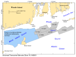
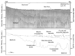
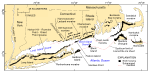
Block Island Sound is a semi-enclosed coastal body of water that is bordered on the south by Block Island and the Atlantic Ocean, and on the north by the southwestern coast of Rhode Island between Point Judith and Watch Hill Point (fig. 1). It is bordered on the east by Rhode Island Sound and on the west by Fishers Island, Long Island Sound, Gardiners Island, and Montauk Point. Based on onshore outcrops and wells drilled on Fishers Island and Long Island (Fuller, 1914; Suter and others, 1949; Skehan, 2008), earlier workers have suggested that plutonic, metamorphic, and igneous rocks of pre-Mesozoic age probably underlie Block Island Sound (McMaster and others, 1968; McMaster and others, 1980; Needell and Lewis, 1984). In places, the bedrock is unconformably overlain by coastal plain and continental shelf deposits of Cretaceous and middle to early Tertiary age (fig. 3; Needell and others, 1983a; Needell and others, 1983b; Needell and Lewis, 1984). Subsequent fluvial erosion during the late Tertiary and early Pleistocene extensively eroded the bedrock and overlying sediments, carving valleys that coalesce and drain southward across central Block Island Sound (McMastar and Ashraf, 1973; Needell and others, 1983a; Needell and Lewis, 1984). The inner continental shelf offshore of Rhode Island was glaciated at least twice, first during the Illinoian (120 to 200 kyBP), drift from which is exposed on Block Island (Skehan, 2008), and finally during the late Wisconsinan. Two glacial advances across the region during the late Wisconsinan are recorded by the Ronkonkoma-Nantucket terminal end moraine and the Harbor Hill-Roanoke Point-Charlestown-Buzzards Bay recessional end moraine, and their submerged sections are evidenced by bands of gravelly sediment and low ridges (fig. 4; McMaster, 1960; McMaster and others, 1968; Schlee and Pratt, 1970; Sirkin, 1976). The Ronkonkoma-Nantucket moraine, which marks the maximum extent of the Laurentide Ice Sheet at around 20-24 kyBP (Uchupi and others, 1996; Balco and others, 2002), dislocated and thrust faulted the coastal plain deposits. The Gay Head cliffs on western Martha's Vineyard provide an exposed example of the disturbed coastal plain deposits. The Harbor Hill-Roanoke Point-Charlestown-Point Judith-Buzzards Bay-Sandwich moraine line, which partially underlies the northeastern part of the study area, records a readvance at about 18 kyBP during the overall retreat of the Laurentide Ice Sheet (fig. 4; Larson, 1982; Oldale and O'Hara, 1984; Boothroyd, 2001; Balco and others, 2002). Where exposed on the sea floor, the moraines offshore of Rhode Island are commonly capped by a lag deposit of gravel and boulders resulting from winnowing of the till by marine processes (Knebel and others, 1982; Poppe and others, 2011). Freshwater proglacial lakes formed between the moraines and the melting ice as the ice sheet made its retreat, depositing thick accumulations of fine-grained glaciolacustrine strata in the area presently occupied by Block Island Sound (fig. 3; Bertoni and others, 1977; Needell and Lewis, 1984; Needell and Lewis, 1985; Uchupi and others, 2001; Poppe and others, 2006). As spillway in the terminal moraine eroded, the glacial lakes in Block Island and Rhode Island Sounds drained and inner shelf was subaerially exposed. Streams drained the landscape, cutting valleys into the unconsolidated glaciolacustrine deposits. As sea level rose, the valleys and lowlands were partly filled by fluvial sediments and covered by estuarine and marsh deposits (Needell and others, 1983a). The sea floor was reworked and smoothed by the transgressing sea; beach, barrier, and Holocene marine sediments were variably deposited. Modern conditions continue to rework and redistribute the surface sediments in Block Island Sound. Where constricted, such as near the entrances to Long Island Sound, adjacent to Watch Hill Point, and in the passages between Montauk Point and Block Island and between Point Judith and Block Island, tidal currents are strong and can exceed 5.2, 2.3, 2.6, and 2.5 kt, respectively (White and White, 2009). Elsewhere, tidal currents in Block Island Sound are much weaker, averaging less than 1 kt. Although strong storms frequently impact the coast of southern New England, the submerged segment of the terminal moraine between Montauk Point and Block Island provides some protection from wave-driven currents. |

![]() U.S. Department of the Interior |
U.S. Geological Survey
U.S. Department of the Interior |
U.S. Geological Survey
URL: http://pubsdata.usgs.gov/pubs/of/2012/1005/html/setting.html
Page Contact Information: GS Pubs Web Contact
Page Last Modified: Tuesday, 22-Jul-2014 11:48:10 EDT