H12013_PHOTOGRAPHS: SEABOSS Images from U.S. Geological Survey (USGS) Cruises 2009-059-FA and 2010-010-FA in JPEG Format

Metadata also available as [Outline] - [Parseable text]

Frequently-anticipated questions:


What does this data set describe?

Title:
H12013_PHOTOGRAPHS: SEABOSS Images from U.S. Geological Survey (USGS) Cruises 2009-059-FA and 2010-010-FA in JPEG Format
Abstract:
The U.S. Geological Survey (USGS), in cooperation with the National Oceanic and Atmospheric Administration (NOAA) and the Connecticut Department of Energy and Environmental Protection (CT DEEP), is producing detailed geologic maps of the coastal sea floor. Bathymetry and sidescan-sonar imagery, originally collected by NOAA for charting purposes, provide a fundamental framework for research and management activities in Long Island Sound, shows the composition and terrain of the seabed, and provides information on sediment transport and benthic habitat. During April-May 2009 NOAA completed hydrographic survey H12013 offshore of the entrance to the Connecticut River, and during November 2009 and April 2010 bottom photographs and surficial sediment data were acquired as part of two ground-truth reconnaissance surveys of this area. Two interpretive data layers were derived from the multibeam echo-sounder and the ground-truth data used to verify them. For more information on the ground-truth surveys see: <http://woodshole.er.usgs.gov/operations/ia/public_ds_info.php?fa=2009-059-FA> and <http://woodshole.er.usgs.gov/operations/ia/public_ds_info.php?fa=2010-010-FA>
  1. How should this data set be cited?

    Poppe, L.J., 2013, H12013_PHOTOGRAPHS: SEABOSS Images from U.S. Geological Survey (USGS) Cruises 2009-059-FA and 2010-010-FA in JPEG Format: Open-File Report 2012-1103, U.S. Geological Survey, Coastal and Marine Geology Program, Woods Hole Coastal and Marine Science Center, Woods Hole, MA.

    Online Links:

    This is part of the following larger work.

    Poppe, L.J., McMullen, K.Y., Ackerman, S.D., Guberski, M.R., and Wood, D.A., 2013, Sea-floor character and geology off the entrance to the Connecticut River, northeastern Long Island Sound: Open-File Report 2012-1103, U.S. Geological Survey, Coastal and Marine Geology Program, Woods Hole Coastal and Marine Science Center, Woods Hole, MA.

    Online Links:

    Other_Citation_Details: 1 DVD-ROM

  2. What geographic area does the data set cover?

    West_Bounding_Coordinate: -72.337818
    East_Bounding_Coordinate: -72.243759
    North_Bounding_Coordinate: 41.286838
    South_Bounding_Coordinate: 41.242607

  3. What does it look like?

    <http://pubs.usgs.gov/of/2012/1103/data/botphotos/h12013_photographs.gif> (GIF)
    Thumbnail image showing location and extent of bottom photo locations off the entrance to the Connecticut River in eastern Long Island Sound

  4. Does the data set describe conditions during a particular time period?

    Beginning_Date: 09-Nov-2009
    Ending_Date: 17-Apr-2010
    Currentness_Reference:
    ground condition; there were actually three days of photographic data collection: 20091109, 20091111, and 20100417

  5. What is the general form of this data set?

    Geospatial_Data_Presentation_Form: raster digital data

  6. How does the data set represent geographic features?

    1. How are geographic features stored in the data set?

      This is a Raster data set.

    2. What coordinate system is used to represent geographic features?

  7. How does the data set describe geographic features?


    Entity_and_Attribute_Overview:
    Fifty-nine mid-res and high-res SEABOSS bottom photographs from cruises 2009-059-FA 2010-015-FA in JPEG format.


Who produced the data set?

  1. Who are the originators of the data set? (may include formal authors, digital compilers, and editors)

  2. Who also contributed to the data set?

  3. To whom should users address questions about the data?

    Larry Poppe
    U.S. Geological Survey
    Geologist
    384 Woods Hole Road
    Woods Hole, MA 02543-1598
    USA

    (508) 548-8700 x2314 (voice)
    (508) 457-2310 (FAX)
    lpoppe@usgs.gov


Why was the data set created?

The purpose of this dataset is to release the mid-resolution and full-resolution JPEG images of photographs of the sea floor acquired off the entrance to the Connecticut River in eastern Long Island Sound, with a SEABOSS system during USGS surveys 2009-059-FA and 2010-010-FA conducted aboard the RV Rafael during November 2009 and April 2010. These photographs can be used to provide information on surface geology, sedimentary processes, and habitats.


How was the data set created?

  1. From what previous works were the data drawn?

    (source 1 of 1)
    Source_Contribution:
    The Mini SEABOSS was designed specifically for the USGS Woods Hole Science Center's 26-foot research vessel Rafael. This system is equipped with two video cameras, a digital still camera, and a van Veen grab sampler. This system, weighing approximately 200 lbs, can be used to depths up to 40 meters. The grab itself is raised and lowered with a 3/16-inch Aramid fiber winch-line with a breaking strength of 5,600 pounds. The davit is secured when the Mini SEABOSS is in the water. The electrical cable is on a spring-wound take-up reel with electrical slip rings that is mounted aft of the sampler. This arrangement protects the 0.38-in. multi-conductor cable and keeps the Mini SEABOSS correctly oriented with the boat. This multi-conductor cable enables communication between the ship's lab and the Mini SEABOSS system. The digital camera, a Minolta Dimage 7Hi, is mounted in a machined Delrin housing with a flat port and is set for 2560 x 1920 pixel images at the "fine" setting for compression. This allows the camera to be used for over 200 images with a 1 GB Compact Flash card without downloading. The system also has a 50 Watt/second flash unit powered by 8 AA batteries. Two battery-powered lasers are set 15 cm apart for scale measurements. The red laser dots can usually be seen in the photo depending on the bottom type and the distance to the sea floor. A third battery powered laser is positioned at an angle so that when it intersects the other lasers, the Mini SEABOSS is at the optimum height off the bottom for a still photograph. The camera is set to a manual focus and set to a default focus distance once the camera is powered up. The default focus distance is slightly less than the optimum height above the seafloor to account for optical distortion under water. For more information on the SEABOSS system please see the cross references.

  2. How were the data generated, processed, and modified?

    Date: 2009 (process 1 of 3)
    The USGS Mini SEABOSS system was deployed to capture still photos and bottom imagery off the entrance to the Connecticut River in Long Island Sound as part of USGS RV Rafael cruises 2009-059-FA and 2010-010-FA.This system was used to obtain 2 to 5 still photographs at each station as the vessel drifted over the seabed for 2 to 5 minutes. Two lasers were set to provide scale; the third laser on the system was set to an angle such that the optimum photograph height was 50 cm. The default focus on the camera was set to 50 cm. The imaged area is most often within 0.4 to 0.7 meter from left to right. Other camera settings on the Mini SEABOSS are as follows: aperture is set at f/8; shutter speed is 1/250 second; digital Effects settings are Color +1, Contrast +1, and Filter +1 (Warming). The camera time is set to GMT. A total of 59 images of the sea floor were acquired. Although the images themselves have no georeferencing information, the time in the EXIF header of each image is related to the navigation available in an ESRI formatted shapefile: h12013_botphotos.shp. This data can be downloaded from the following locations: <http://pubs.usgs.gov/of/2012/1103/data/botphotos/h12013_botphotos.zip>; <http://pubs.usgs.gov/of/2012/1103/html/catalog.html>

    Person who carried out this activity:

    Dann Blackwood
    U.S. Geological Survey
    Photographer
    384 Woods Hole Road
    Woods Hole, MA 02543-1598
    USA

    (508) 548-8700 x2227 (voice)
    (508) 457-2310 (FAX)
    dblackwood@usgs.gov

    Date: 2009 (process 2 of 3)
    The digital images were recorded on a flash card within the camera and transferred from the camera at the end of the day. This transfer was accomplished by removing the card from the camera and using a card reader connected to a Mac OSX system.

    Person who carried out this activity:

    Dann Blackwood
    U.S. Geological Survey
    Photographer
    384 Woods Hole Road
    Woods Hole, MA 02543

    508-548-8700 x2227 (voice)
    508-457-2310 (FAX)
    dblackwood@usgs.gov

    Date: 2010 (process 3 of 3)
    The full-resolution JPEG images (2560x1920 pixels) were downsampled using Photoshop CS to create JPEG images with 600 x 450 pixels. The filenames indicate the resolution. For instance, the full-resolution JPEG image - ol7_3fr.jpg - was downsampled to produce mid-resolution JPEG image ol7_3mr.jpg.

    Person who carried out this activity:

    Larry Poppe
    U.S. Geological Survey
    Photographer
    384 Woods Hole Road
    Woods Hole, MA 02543

    508-548-8700 x2314 (voice)
    508-457-2310 (FAX)
    lpoppe@usgs.gov

  3. What similar or related data should the user be aware of?

    Blackwood, D.S., and Parolski, K.F., 2001, Seabed observation and sampling system: Sea Technology February 2001, v. 44, no. 2, Sea Technology.

    Valentine, P.C., Blackwood, D.S., and Parolski, K.F., 2002, Seabed observation and sampling system: Fact Sheet 136-01, U.S. Geological Survey, Coastal and Marine Geology Program, Woods Hole Science Center, Woods Hole, MA.

    Online Links:


How reliable are the data; what problems remain in the data set?

  1. How well have the observations been checked?

  2. How accurate are the geographic locations?

  3. How accurate are the heights or depths?

  4. Where are the gaps in the data? What is missing?

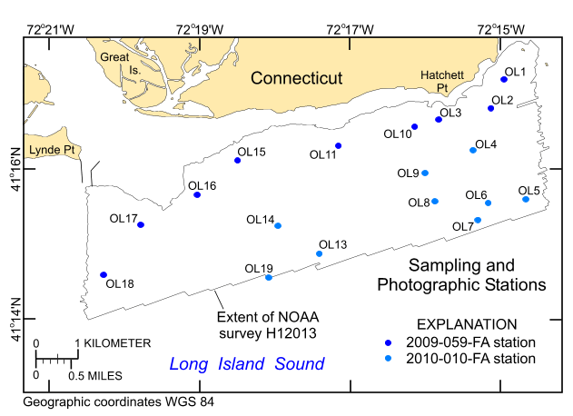
    All images of the sea floor collected within the study area off the entrance to the Connecticut River in eastern Long Island Sound, on cruises 2009-059-FA and 2010-015-FA with the Mini SEABOSS system are included. Total station numbers range from OL1 to OL19, but no photographs were acquired at stations OL12 (skipped due to weather) and OL14 (high turbidity prevented visibility). Not all of the photos collected on the cruises were collected within the study area.

  5. How consistent are the relationships among the observations, including topology?


How can someone get a copy of the data set?

Are there legal restrictions on access or use of the data?

Access_Constraints: None
Use_Constraints:
Public domain data from the U.S. government are freely redistributable with proper metadata and source attribution. Please recognize the U.S. Geological Survey (USGS) as the source of this information.

  1. Who distributes the data set? (Distributor 1 of 1)

    Larry Poppe
    U.S. Geological Survey
    Geologist
    384 Woods Hole Road
    Woods Hole, MA 02543-1598
    USA

    (508) 548-8700 x2314 (voice)
    (508) 457-2310 (FAX)
    lpoppe@usgs.gov

  2. What's the catalog number I need to order this data set?

    Downloadable Data

  3. What legal disclaimers am I supposed to read?

    Neither the U.S. Government, the Department of the Interior, nor the USGS, nor the National Oceanic and Atmospheric Administration (NOAA), nor the Connecticut Department of Energy and Environmental Protection (CT DEEP) nor any of their employees, contractors, or subcontractors, make any warranty, express or implied, nor assume any legal liability or responsibility for the accuracy, completeness, or usefulness of any information, apparatus, product, or process disclosed, nor represent that its use would not infringe on privately owned rights. The act of distribution shall not constitute any such warranty, and no responsibility is assumed by the USGS, NOAA, or the CT DEEP in the use of these data or related materials. Any use of trade, product, or firm names is for descriptive purposes only and does not imply endorsement by the U.S. Government.

  4. How can I download or order the data?

  5. What hardware or software do I need in order to use the data set?

    These data are available as JPEG images. To utilize these data, the user must have an image viewer capable of opening JPEG images. The full-resolution images are 2560x1920 pixels; the medium resolution images are 600x450 pixels. Although a WinZip file of the full-resolution images is provided, it is large and individuals may want to download the images individually.


Who wrote the metadata?

Dates:
Last modified: 14-Aug-2012
Metadata author:
Larry Poppe
U.S. Geological Survey
Geologist
384 Woods Hole Road
Woods Hole, MA 02543-1598
USA

(508) 548-8700 x2314 (voice)
(508) 457-2310 (FAX)
lpoppe@usgs.gov

Metadata standard:
FGDC Content Standards for Digital Geospatial Metadata (FGDC-STD-001-1998)
Metadata extensions used:


Generated by mp version 2.9.6 on Tue Aug 14 08:47:52 2012