U.S. Geological Survey Open-File Report 2012–1103
Sea-Floor Character and Geology Off the Entrance to the Connecticut River, Northeastern Long Island Sound
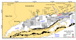
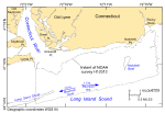
Long Island Sound, a major estuary along the east coast of the United States, is an industrial and recreational resource for the more than 8 million people that live within its watershed (fig. 1; Knebel and others, 2000). The sound is 182 km long and as much as 32 km wide. It is bordered on the north by the rocky shoreline of Connecticut, on the east by The Race and Block Island Sound, and on the south by the eroding sandy bluffs of Long Island. The study area, which covers approximately 29.1 km² of sea floor off the entrance to the Connecticut River, is bordered on the west by Long Sand Shoal and on the northwest and north by the towns of Old Saybrook and Old Lyme, Connecticut, respectively (fig. 2). The surface geology of the sound is a result of glacial and eustatic processes (Schafer and Hartshorn, 1965; Flint and Gebert, 1976; Stone and Borns, 1986; Lewis and Needell, 1987; Needell and others, 1987; Lewis and Stone, 1991; Lewis and DiGiacomo-Cohen, 2000; Stone and others, 2005). The late Wisconsinan Laurentide Ice Sheet scoured the surface, deposited drift, and produced a recessional moraine across northern Long Island and a succession of minor recessional moraines in Connecticut (Goldsmith, 1982). Glacial Lake Connecticut, which occupied most of the Long Island Sound basin, was forming by 19 thousand years before present (kyBP) when meltwater was impounded in the expanding basin between the recessional moraine on Long Island and the retreating ice. Deltaic and varved sediments deposited in this lake variously overlie the glacial drift throughout much of the basin. Erosion of a spillway at its eastern end drained glacial Lake Connecticut by 15.5 kyBP and subaerially exposed the lakebed until the marine transgression that began about 15 kyBP (Lewis and DiGiacomo-Cohen, 2000). The glaciolacustrine deposits of glacial Lake Connecticut and the underlying glacial drift are truncated by a regional unconformity. This unconformity is a composite product of the subaerial exposure and the marine transgression (Needell and others, 1987; Lewis and Stone, 1991). Marine conditions were well established in the sound by 13.5 kyBP, and glacial Lake Hitchcock in central New England was beginning to drain down the Connecticut River valley (Lewis and DiGiacomo-Cohen, 2000). The Hitchcock lake-bottom sediment, transported south by the Connecticut River between 13.5 and 9.5 kyBP (inferred to be about 11.5 billion m³), buried the marine unconformity and built a large marine delta (Stone and others, 2005). From about 13.5 kyBP, the glaciolacustrine and marine deltaic deposits in the eastern sound have been eroded, selectively sorted, and transported westward (Knebel and Poppe, 2000; Poppe and others, 2000; Lewis and DiGiacomo-Cohen, 2000). Circulation within Long Island Sound is tidally dominated and is stronger in constricted areas where large volumes of water must pass through relatively narrow openings and weaker in broad, deeper basins (Koppelman and others, 1976; Signell and others, 2000). However, wind-driven and wave-produced currents are relatively important in shallow, nearshore areas, especially during aperiodic storms when strong winds blow the length of the sound. Minor nontidal estuarine circulation affects residual bottom currents throughout the year (Gordon and Philbeam, 1975; Signell and others, 2000). Together, these currents have extensively reworked the glacial and postglacial deposits in the eastern sound and continue to influence the sedimentary processes and surficial sediment distributions in the study area (Lewis and Stone, 1991; Lewis and DiGiacomo-Cohen, 2000). Tidal currents alone can locally exceed 1.2 m/s just east of Long Sand Shoal (White and White, 2012), and tidal currents at 1 m above the sea floor have been modeled at 30 cm/s in the central study area and at 40 cm/s in the deeper waters along its southern edge (Signell and others, 2000). The flood tide in the vicinity of the study area, which flows westward, is stronger than the ebb tide. The study area lies off the mouth of the Connecticut River, which is the largest river in New England, exceeding 650 km in length and draining about 29,137 km² (Bacon, 1906; Hard, 1947). Mean freshwater discharge from this river is about 483 m³/s, but maximum discharge during the spring snow melt and after storms is about 7,985 m³/s. The river also carries large concentrations of sediment, especially during peak flows (fig. 3). This sediment builds and maintains shoals and affects turbidity throughout much of the eastern sound, including the study area. |