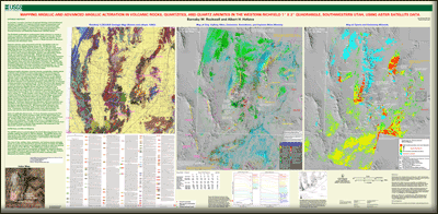
 Abstract Abstract
The Richfield quadrangle in southwestern Utah is known to contain a variety of porphyry Mo, skarn, polymetallic replacement and vein, alunite, and kaolin resources associated with 27–32 Ma calc-alkaline or 12–23 Ma bimodal volcano-plutonic centers in Neoproterozoic to Mesozoic carbonate and siliciclastic rocks. Four scenes of visible to shortwave-infrared image data acquired by the Advanced Spaceborne Thermal Emission and Reflection Radiometer (ASTER) sensor were analyzed to generate maps of exposed clay, sulfate, mica, and carbonate minerals, and ASTER thermal infrared data were analyzed to identify quartz and carbonate minerals.
Argillic and advanced argillic alteration minerals including
alunite, pyrophyllite, dickite, and kaolinite were identified in both
undocumented (U) and known (K) areas, including in the southern
Paradise Mtns. (U); in calc-alkaline volcanic rocks in the Wah Wah Mtns. between Broken Ridge and the NG area (U/K); at Wah Wah Summit in a small zone adjacent to 33.1 Ma diorite and marble (U); in fractures cutting quartzites surrounding the 20–22 Ma Pine Grove Mo deposit (U); in volcanic rocks in the Shauntie Hills (U/K); in quartzites in the west-central San Francisco Mtns. (U); in volcanic rocks in the Black Mtns. (K); and in mainly 12–13 Ma rhyolitic rocks along a 20 km E-W belt that includes the Bible Spring fault zone west of Broken Ridge, with several small centers in the Escalante Desert to the south (U/K). Argillized Navajo Sandstone with kaolinite and (or) dickite ± alunite was mapped adjacent to calc-alkaline intrusions in the Star Range (U). Intense quartz-sericite alteration (K) with local kaolinite was identified in andesite adjacent to calc-alkaline intrusions in the Beaver Lake Mountains. Mo-bearing phyllic alteration was identified in 22.2 Ma rhyolite plugs at the center of the NG alunite area. Limestones, dolomites, and marbles were differentiated, and quartz and sericite were identified in most unaltered quartzites.
Halos of argillically-altered rock ≈12 km in diameter surround the Pine Grove deposit, the central rhyolites at NG, and the North Peaks just south of the Bible Spring fault zone. A southward shift from 22–23 Ma alunite at NG in the northeast to the 12–13 Ma alunite near Broken Ridge in the southwest mirrors a shift in the locus of bimodal magmatism and is similar to the southward shift of activity from the Antelope Range to Alunite Ridge (porphyry Mo potential) in the Marysvale volcanic field farther east.
The poster provided in this report compares mineral maps generated from analysis of combined visible-near infrared (VNIR) and shortwave-infrared (SWIR) data and thermal infrared (TIR) ASTER data to a previously published regional geologic map. Such comparisons are used to identify and differentiate rock-forming and hydrothermal alteration-related minerals, which aids in lithologic mapping and alteration characterization over an 11,245 square kilometer area.
|
First posted July 19, 2012
Part or all of this report is presented in Portable Document Format (PDF); the latest version of Adobe Reader or similar software is required to view it. Download the latest version of Adobe Reader, free of charge. |

