Open-File Report 2012–1190
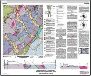 IntroductionThe Stanardsville 7.5-minute quadrangle is located about 30 kilometers north of Charlottesville, Virginia, in the eastern foothills of the Blue Ridge and within the Blue Ridge physiographic province. The quadrangle contains a small part of the eastern margin of Shenandoah National Park along Saddleback Mountain just north of Swift Run Gap and stretches of Swift Run and the South, Conway, and Rapidan Rivers. The broad valleys occupied by these southeast-draining streams alternate with ridges as much as 1,700 feet high to produce a varied topography, with the 3,000- to 4,000-foot-high Blue Ridge defining the western horizon. The bedrock geology of the quadrangle was mapped at a scale of 1:24,000 as part of the Geology of Shenandoah National Park Project (which was conducted from 1995 to 2008) of the U.S. Geological Survey National Cooperative Geologic Mapping Program. The results of the mapping were incorporated in the Geologic Map of the Shenandoah National Park Region, Virginia (USGS Open-File Report 2009-1153). |
First posted October 17, 2012
For additional information contact: Part or all of this report is presented in Portable Document Format (PDF); the latest version of Adobe Reader or similar software is required to view it. Download the latest version of Adobe Reader, free of charge. |
Burton, W.C., Bailey, C.M., and Crider, E.A., 2012, Preliminary geologic map of the Stanardsville 7.5' quadrangle, Greene and Madison Counties, Virginia: U.S. Geological Survey Open-File Report 2012–1190, one sheet, scale 1:24,000, available only at http://pubs.usgs.gov/of/2012/1190.
Introduction
Bedrock Lithologies
Surficial Deposits
Structure and Metamorphism
References Cited

![]() U.S. Department of the Interior |
U.S. Geological Survey
U.S. Department of the Interior |
U.S. Geological Survey
URL: http://pubsdata.usgs.gov/pubs/of/2012/1190/index.html
Page Contact Information: GS Pubs Web Contact
Page Last Modified: Saturday, 12-Jan-2013 15:31:19 EST
