Open-File Report 2012–1205
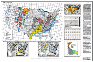
AbstractThis map sheet with accompanying Geographic Information System (GIS) project is an update of the existing U.S. Geological Survey (USGS) Conterminous U.S. Coal Fields map. This update was compiled using data primarily from the USGS National Coal Resource Assessment (NCRA) and information from other published maps. The five regions examined by NCRA (Eastern, Gulf Coast, Interior, Rocky Mountain, and Northern Great Plains) constituted 93 percent of U.S. coal production at the time of the assessments. The map sheet shows aerial extent, rank, province, name (region and field), and age information, which are also attributes of the GIS project. Due to changing technological and economic constraints for coal usage, along with the potential for geologic carbon dioxide sequestration, this map sheet and the GIS component of this report do not differentiate between potentially minable coal and uneconomic coal. Additional figures on the map sheet show coal formations, current production by State, coal rank definitions, and charts showing historical trends of coal production. 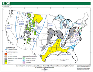
Simplified Presentation Format (2021)“Coal Fields of the Conterminous United States—National Coal Resource Assessment Updated Version in Simplified Presentation Format” is a smaller-scale, Powerpoint-friendly version of Open-File Report 2012–1205. It consists of a simplified version of the map, with no supporting text discussion or figures. On the map, State names and county boundaries have been omitted and the graticule simplified. None of the data on the map has been revised from the original, only made more visually appealing at a smaller scale by omitting the outline of the National Coal Resource Assessment area and omitting labels for individual coal fields, less-significant coal regions, and Triassic basins. |
First posted April 2, 2013
For additional information contact: Part or all of this report is presented in Portable Document Format (PDF); the latest version of Adobe Reader or similar software is required to view it. Download the latest version of Adobe Reader, free of charge. |
East, J.A., 2013, Coal fields of the conterminous United States—National Coal Resource Assessment updated version: U.S. Geological Survey Open-File Report 2012–1205, one sheet, scale 1:5,000,000, available at http://pubs.usgs.gov/of/2012/1205/.
Introduction
Discussion
References Cited

![]() U.S. Department of the Interior |
U.S. Geological Survey
U.S. Department of the Interior |
U.S. Geological Survey
URL: http://pubsdata.usgs.gov/pubs/of/2012/1205/index.html
Page Contact Information: GS Pubs Web Contact
Page Last Modified: Wednesday, 15-Dec-2021 16:37:45 EST
