 |
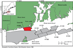
Figure 1. Map showing the location of National Oceanic and Atmospheric Administration (NOAA) survey H12023 (red-shaded polygon) offshore of Rhode Island in Block Island Sound. Also shown are other NOAA surveys (gray-shaded polygons) that have been interpreted in this series in Rhode Island and Block Island sounds including H11320 (McMullen and others, 2007), H11321 (McMullen and others, 2008), H11322 (McMullen and others, 2009), H11922 (Poppe and others, 2011), H11995 (McMullen and others, 2012), H11996 (McMullen and others, 2011), and Block Island Sound survey, a combination of surveys H12009, H12010, H12011, H12015, H12033, H12137, and H12139 (Poppe and others, 2012). |
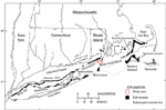 |
Figure 2. Map of end moraines (black polygons) and submerged ridges (dashed lines) in southern New York and New England (modified from Gustavson and Boothroyd, 1987) with the study area (red-outline polygon). The Ronkonkoma-Block Island-Nantucket terminal moraine represents the maximum advance of the Laurentide Ice Sheet about 20,000 to 24,000 years ago, whereas the Harbor Hill-Roanoke Point-Charlestown-Buzzards Bay end moraine represents a retreated ice-sheet position from about 18,000 years ago (Uchupi and others, 2001). |
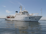 |
Figure 3. Starboard-side view of National Oceanic and Atmospheric Administration ship Thomas Jefferson, which was used to collect bathymetric data in the study area. |
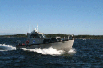 |
Figure 4. National Oceanic and Atmospheric Administration launch 3102, one of two aluminum survey launches used to collect bathymetric and sidescan-sonar data in the study area. |
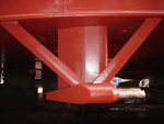 |
Figure 5. A RESON SeaBat 7125 multibeam echosounder, which is hull-mounted to National Oceanic and Atmospheric Administration ship Thomas Jefferson and was used to collect bathymetric data. A SeaBat 7125 was also mounted on launch 3102. |
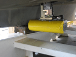 |
Figure 6. A RESON SeaBat 8125 multibeam echosounder, which is hull-mounted to National Oceanic and Atmospheric Administration launch 3101 and was used to collect bathymetric data. |
 |
Figure 7. A Klein 5000 hull-mounted on National Oceanic and Atmospheric Administration launch 3101 used to collect sidescan-sonar data. |
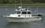 |
Figure 8. Port-side view of the U.S. Geological Survey research vessel Rafael, which was used to collect sediment and photographic data. |
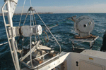 |
Figure 9. The small Seabed Observation and Sampling System (SEABOSS), a modified Van Veen grab sampler with attached still and video cameras, on the aft starboard side of the U.S. Geological Survey research vessel Rafael. The system uses a winch, mounted on a davit (left), and a take-up reel for the video-signal and power cable (right). |
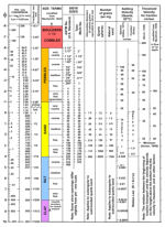 |
Figure 10. Chart showing the relations among phi sizes, millimeter diameters, size classifications (Wentworth, 1922), and American Society for Testing and Materials and Tyler sieve sizes. Chart also shows the corresponding intermediate diameters, grains per milligram, settling velocities, and threshold velocities for traction. cm/sec, centimeter per second; m, meter; mg, milligram; mm, millimeter; µm, micrometer; no., number; °C, degrees Celsius; ", inch. |
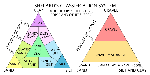 |
Figure 11. Sediment-classification scheme from Shepard (1954), as modified by Schlee (1973) and Poppe and others (2004). %, percent; <, less than. |
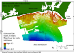 |
Figure 12. Hill-shaded multibeam-bathymetric image of National Oceanic and Atmospheric Administration (NOAA) survey H12023 in northern Block Island Sound. Warm colors (reds) represent shallow areas and cool colors (blues) represent deep areas. Boxes mark locations of figures 14, 15, 17, and 18. |
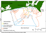 |
Figure 13. Map showing interpretation of the sea floor in National Oceanic and Atmospheric Administration (NOAA) survey H12023 including bedforms, scour depressions and erosional outliers, and boulders. Areas that are not outlined represent predominately undisturbed modern marine sediments. Interpretations are based on multibeam-echosounder, sidescan-sonar, sedimentary, and bottom-photographic data. |
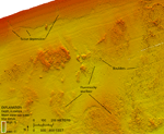 |
Figure 14. Detailed multibeam-bathymetric image of boulders and scour depressions along the northern edge of the study area. Boulders are often found in hummocky areas. Scour depressions near the coast tend to have northward reaching fingers; however, the main bodies of the depressions widen offshore, opening into large scoured areas that parallel the coast. Location shown in figure 12. |
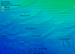 |
Figure 15. Detailed multibeam-bathymetric image of scour depressions and erosional outliers (positive local relief) in the southern part of the study area. In these deep areas, large depressions and outliers tend to trend east-west, but the small, deep depressions trend north-south. Also visible are a few boulders within a scour depression. Location shown in figure 12. |
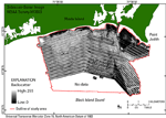 |
Figure 16. Image of sidescan-sonar data from National Oceanic and Atmospheric Administration (NOAA) survey H12023. Dark-shades are low backscatter and generally represent finer grained sediments and acoustic shadows; light-shades are high backscatter and generally represent coarser grained sediment and high acoustic reflectivity. Note that sidescan-sonar data were not collected in the entire survey area; stripes oriented along survey tracklines are artifacts of the data acquisition and processing and were not tonally matched. |
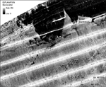 |
Figure 17. Detailed sidescan-sonar image of boulders and scour depressions along the northern edge of the study area. Boulders are visible as white targets with black shadows. Scour depressions are represented by light tones and are coarser grained than the surrounding finer grained sea floor, which is represented by dark tones. Stripes oriented along survey tracklines are artifacts of the data acquisition and processing. Location shown in figure 12. |
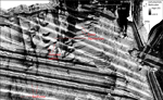 |
Figure 18. Detailed sidescan-sonar image of scour depressions and erosional outliers to the west of the Point Judith Harbor entrance. Currents related to the protective jetty extending from the harbor may influence the unusual east-west orientations of these sea-floor features relative to others in the study area, which predominately trend north-south. Broad, low-relief bedforms with coarser troughs and finer crests are in the lower left. Stripes oriented along survey tracklines are artifacts of the data acquisition and processing. Location shown in figure 12. |
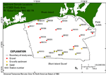 |
Figure 19. Map showing the locations of sediment samples taken during U.S. Geological Survey cruise 2012-002-FA on the research vessel (RV) Rafael. Warmer colors (red and orange) represent coarser sediment and cooler colors (yellow) represent finer sediment. |
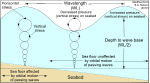 |
Figure 20. Illustration showing the maximum depth that is affected by orbital wave motion, called the wave base, as it is related to wavelength. Vertical stresses affect the sea floor above and below the wave base due to the loading and unloading of pressure by passing waves. |
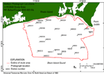 |
Figure 21. Map showing the locations of photographs of the sea floor taken during U.S. Geological Survey cruise 2012-002-FA on the research vessel (RV) Rafael. |
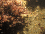 |
Figure 22. Photograph of gravel and boulders on the sea floor at U.S. Geological Survey sampling station NBIS14. Boulders are commonly overgrown with sessile fauna and flora. |
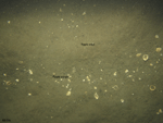 |
Figure 23. Photograph of rippled sand on the sea floor at U.S. Geological Survey sampling station NBIS9. Shells and coarser sediment can be seen collecting in the ripple troughs. |


