U.S. Geological Survey Open-File Report 2013–1003
Sea-Floor Geology in Northeastern Block Island Sound, Rhode Island
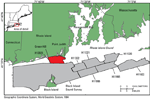
Multibeam-echosounder (MBES) and sidescan-sonar data, originally collected by the National Oceanic and Atmospheric Administration (NOAA) during hydrographic surveys, can be used to interpret sea-floor geology when combined with sediment samples and bottom photography. During 2009 and 2011, NOAA collected MBES and sidescan-sonar data as part of survey H12023, which covered 52 square kilometers (km²) adjacent to the shore of Rhode Island, from Green Hill to Point Judith, R.I., in northeastern Block Island Sound (fig. 1). The U.S. Geological Survey (USGS) subsequently collected sea-floor sediment samples, still photographs, and sea floor (bottom) video at 26 stations within this survey area. The purpose of this report is (1) to interpret the sea-floor features and sedimentary environments in this area and (2) to make available the MBES, sidescan-sonar, sediment, and photographic data collected in the study area. This information can be used as a base map for future studies in areas such as benthic ecology and resource management. |

![]() U.S. Department of the Interior |
U.S. Geological Survey
U.S. Department of the Interior |
U.S. Geological Survey
URL: http://pubsdata.usgs.gov/pubs/of/2013/1003/html/intro.html
Page Contact Information: GS Pubs Web Contact
Page Last Modified: Wednesday, 21-Aug-2013 16:08:13 EDT